File:Fort Washington, Fort Washington Park, Maryland, official map and guide LOC 94681513.tif
Jump to navigation
Jump to search

Size of this JPG preview of this TIF file: 800 × 286 pixels. Other resolutions: 320 × 114 pixels | 640 × 229 pixels | 1,024 × 366 pixels | 1,280 × 457 pixels | 2,560 × 915 pixels | 9,986 × 3,568 pixels.
Original file (9,986 × 3,568 pixels, file size: 101.94 MB, MIME type: image/tiff)
Captions
Captions
Add a one-line explanation of what this file represents
Summary[edit]
| Description |
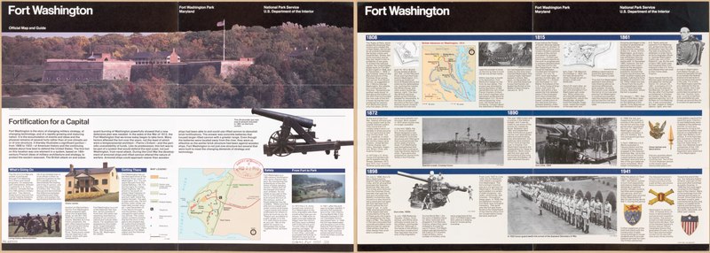
English: Covers entire park. "*GPO: 1993--342-398/80053." Panel title. Title at top on verso: Fort Washington, Fort Washington Park, Maryland. Includes text and col. ill. Text, 2 maps of fort vicinity, map of "British advance on Washington, 1814," and ill. (some col.) on verso. Available also through the Library of Congress Web site as a raster image. |
||
| Title | Fort Washington, Fort Washington Park, Maryland, official map and guide | ||
| Shelf ID | G3842.F67 1993 .U5 | ||
| Date | |||
| Source | https://www.loc.gov/item/94681513/ | ||
| Author | United States. National Park Service | ||
| Permission (Reusing this file) |
|
||
| Other versions |
|
||
| Location | United States · Fort Washington Park · Maryland · Fort Washington Park. | ||
| Part of | American Memory · General Maps · Catalog · Geography And Map Division | ||
| Subject | United States · Maps · Maryland · Fort Washington Park (Md.) · Fort Washington Park |

Licensing[edit]
| This image or media file contains material based on a work of a National Park Service employee, created as part of that person's official duties. As a work of the U.S. federal government, such work is in the public domain in the United States. See the NPS website and NPS copyright policy for more information. |
File history
Click on a date/time to view the file as it appeared at that time.
| Date/Time | Thumbnail | Dimensions | User | Comment | |
|---|---|---|---|---|---|
| current | 23:10, 20 May 2018 | 9,986 × 3,568 (101.94 MB) | Fæ (talk | contribs) | LOC Maps https://www.loc.gov/item/94681513/ #12541 |
You cannot overwrite this file.
File usage on Commons
The following page uses this file: