File:Florida EPA level IV ecoregions map.pdf
Jump to navigation
Jump to search

Size of this JPG preview of this PDF file: 776 × 600 pixels. Other resolutions: 311 × 240 pixels | 621 × 480 pixels | 994 × 768 pixels | 1,280 × 989 pixels | 1,650 × 1,275 pixels.
Original file (1,650 × 1,275 pixels, file size: 818 KB, MIME type: application/pdf)
Captions
Captions
Add a one-line explanation of what this file represents
Summary[edit]
| Description |
English: Map of Level IV ecoregions in the U.S. state of Florida, as defined by the United States Environmental Protection Agency.
|
|||||
| Date | ||||||
| Source | https://www.epa.gov/eco-research/ecoregion-download-files-state-region-4 (file is at ftp://newftp.epa.gov/EPADataCommons/ORD/Ecoregions/fl/fl_eco_pg.pdf) | |||||
| Author | Glenn E. Griffith, James M. Omernik, and Suzanne M. Pierson |
File history
Click on a date/time to view the file as it appeared at that time.
| Date/Time | Thumbnail | Dimensions | User | Comment | |
|---|---|---|---|---|---|
| current | 23:16, 16 February 2019 | 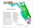 | 1,650 × 1,275 (818 KB) | TimK MSI (talk | contribs) | {{Information |description ={{en|1=Map of Level IV ecoregions in the U.S. state of Florida, as defined by the United States Environmental Protection Agency. {{PD-USGov-EPA}}}} |date =2003 |source =https://www.epa.gov/eco-research/ecoregion-download-files-state-region-4 (file is at ftp://newftp.epa.gov/EPADataCommons/ORD/Ecoregions/fl/fl_eco_pg.pdf) |author =Glenn E. Griffith, James M. Omernik, and Suzanne M. Pierson }} Category:Maps of Florida [[Category:Maps of... |
You cannot overwrite this file.
File usage on Commons
The following page uses this file:
- File:Fl eco pg.pdf (file redirect)