File:DETAIL OF SOUTHEAST SIDE OF FOURTH STREET VIADUCT SHOWING ORNAMENTAL LIGHTING AND STAIRS AT MISSION STREET OVERCROSSING. LOOKING NORTHEAST. - Fourth Street Viaduct, Spanning Los Angeles HAER CA-280-7.tif
Jump to navigation
Jump to search

Size of this JPG preview of this TIF file: 742 × 600 pixels. Other resolutions: 297 × 240 pixels | 594 × 480 pixels | 950 × 768 pixels | 1,267 × 1,024 pixels | 2,534 × 2,048 pixels | 5,319 × 4,299 pixels.
Original file (5,319 × 4,299 pixels, file size: 21.81 MB, MIME type: image/tiff)
Captions
Captions
Add a one-line explanation of what this file represents
Summary[edit]
| DETAIL OF SOUTHEAST SIDE OF FOURTH STREET VIADUCT SHOWING ORNAMENTAL LIGHTING AND STAIRS AT MISSION STREET OVERCROSSING. LOOKING NORTHEAST. - Fourth Street Viaduct, Spanning Los Angeles River, Los Angeles, Los Angeles County, CA | ||||
|---|---|---|---|---|
| Photographer |
Grogan, Brian Related names:
|
|||
| Title |
DETAIL OF SOUTHEAST SIDE OF FOURTH STREET VIADUCT SHOWING ORNAMENTAL LIGHTING AND STAIRS AT MISSION STREET OVERCROSSING. LOOKING NORTHEAST. - Fourth Street Viaduct, Spanning Los Angeles River, Los Angeles, Los Angeles County, CA |
|||
| Depicted place | California; Los Angeles County; Los Angeles | |||
| Date | 2001 | |||
| Dimensions | 4 x 5 in. | |||
| Current location |
Library of Congress Prints and Photographs Division Washington, D.C. 20540 USA http://hdl.loc.gov/loc.pnp/pp.print |
|||
| Accession number |
HAER CA-280-7 |
|||
| Credit line |
|
|||
| Notes |
|
|||
| Source | https://www.loc.gov/pictures/item/ca2905.photos.193929p | |||
| Permission (Reusing this file) |
|
|||

| Object location | | View this and other nearby images on: OpenStreetMap |
|---|
File history
Click on a date/time to view the file as it appeared at that time.
| Date/Time | Thumbnail | Dimensions | User | Comment | |
|---|---|---|---|---|---|
| current | 23:33, 5 July 2014 | 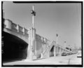 | 5,319 × 4,299 (21.81 MB) | Fæ (talk | contribs) | GWToolset: Creating mediafile for Fæ. HABS 05 July 2014 (501:600) |
You cannot overwrite this file.
File usage on Commons
The following page uses this file: