File:Chronoplus transport map.svg
Jump to navigation
Jump to search

Size of this PNG preview of this SVG file: 455 × 599 pixels. Other resolutions: 182 × 240 pixels | 364 × 480 pixels | 583 × 768 pixels | 777 × 1,024 pixels | 1,555 × 2,048 pixels | 744 × 980 pixels.
Original file (SVG file, nominally 744 × 980 pixels, file size: 518 KB)
Captions
Captions
Add a one-line explanation of what this file represents
Summary[edit]
| Description |
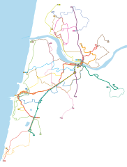
Français : Carte du réseau de transport en commun Chronoplus (Agglomération Côte Basque-Adour). |
| Date | |
| Source | Plan officiel du réseau Chronoplus (2013-2014 V2) |
| Author | Carte : Syndicat des Transports de l'Agglomération Côte basque-Adour, vectorisation : Flappiefh |
Licensing[edit]
This work is based on a work in the public domain. It has been digitally enhanced and/or modified. This derivative work has been (or is hereby) released into the public domain by its author, Flappiefh. This applies worldwide.
In some countries this may not be legally possible; if so: |
File history
Click on a date/time to view the file as it appeared at that time.
| Date/Time | Thumbnail | Dimensions | User | Comment | |
|---|---|---|---|---|---|
| current | 17:28, 11 August 2013 | | 744 × 980 (518 KB) | Flappiefh (talk | contribs) | User created page with UploadWizard |
You cannot overwrite this file.
File usage on Commons
The following page uses this file:
File usage on other wikis
The following other wikis use this file:
- Usage on fr.wikipedia.org
- Usage on www.wikidata.org