File:Chesapeake Bay watershed, percent change in farming of prime farmland 1982-1992 LOC 95684471.tif
Jump to navigation
Jump to search

Size of this JPG preview of this TIF file: 467 × 600 pixels. Other resolutions: 187 × 240 pixels | 374 × 480 pixels | 598 × 768 pixels | 797 × 1,024 pixels | 1,594 × 2,048 pixels | 2,606 × 3,348 pixels.
Original file (2,606 × 3,348 pixels, file size: 24.96 MB, MIME type: image/tiff)
Captions
Captions
Add a one-line explanation of what this file represents
Summary[edit]
| Description |
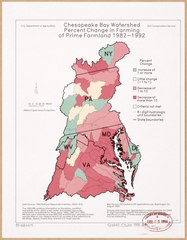
English: Shows increase/decrease of prime farmland by 10% increments within hydrologic units (regions). Also covers Susquehanna River watershed. Includes notes. "6-49." Available also through the Library of Congress Web site as a raster image. |
||
| Title | Chesapeake Bay watershed, percent change in farming of prime farmland 1982-1992 | ||
| Shelf ID | G3842.C5J15 1992 .U5 | ||
| Date | d1992 | ||
| Source | https://www.loc.gov/item/95684471/ | ||
| Author | United States. Soil Conservation Service | ||
| Permission (Reusing this file) |
|
||
| Other versions |
|
||
| Location | Chesapeake Bay Watershed · Susquehanna River Watershed | ||
| Part of | American Memory · Catalog · Geography And Map Division · Additional Conservation And Environment Cartographic Items | ||
| Subject | Chesapeake Bay Watershed · Pennsylvania · Agriculture · Delaware · Virginia · Susquehanna River Watershed · United States · Maps · District Of Columbia · West Virginia · Land Use, Rural · Maryland · New York (State) · Economic Aspects |


Licensing[edit]
| This work is from the Library of Congress. According to the library, there are no known copyright restrictions on the use of this work. |  |
File history
Click on a date/time to view the file as it appeared at that time.
| Date/Time | Thumbnail | Dimensions | User | Comment | |
|---|---|---|---|---|---|
| current | 01:39, 7 November 2018 |  | 2,606 × 3,348 (24.96 MB) | Fæ (talk | contribs) | LOC Maps https://www.loc.gov/item/95684471/ #1003 |
You cannot overwrite this file.
File usage on Commons
The following page uses this file: