File:Caribbean maritime boundaries map.svg
Jump to navigation
Jump to search

Size of this PNG preview of this SVG file: 800 × 499 pixels. Other resolutions: 320 × 200 pixels | 640 × 399 pixels | 1,024 × 639 pixels | 1,280 × 798 pixels | 2,560 × 1,597 pixels | 3,561 × 2,221 pixels.
Original file (SVG file, nominally 3,561 × 2,221 pixels, file size: 2.78 MB)
Captions
Captions
Add a one-line explanation of what this file represents
Summary[edit]
| Description |
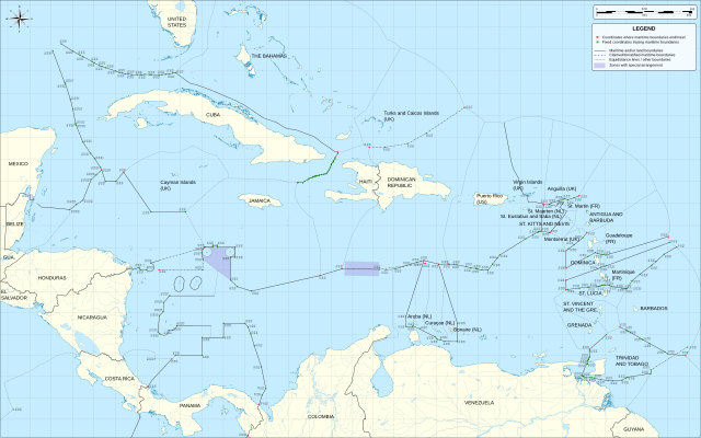
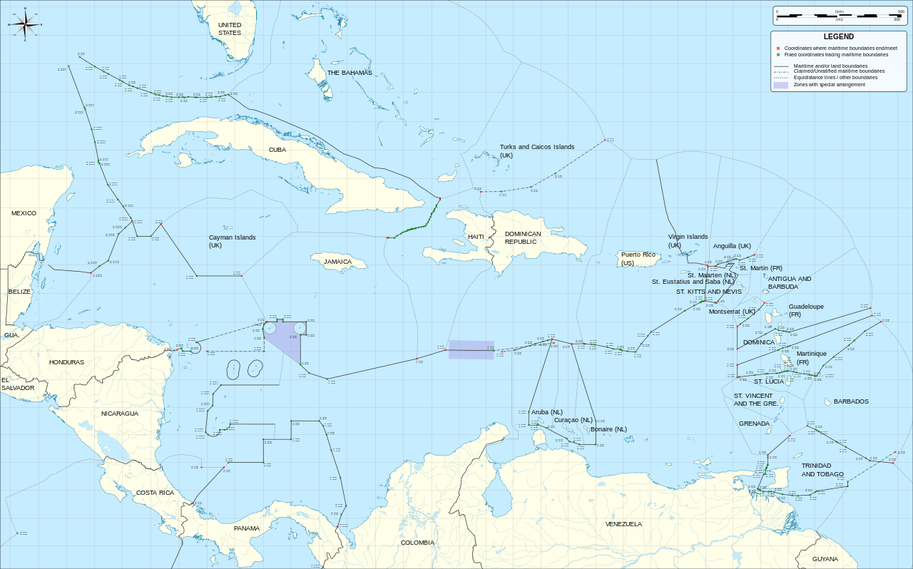
English: Map of maritime boundaries in the Caribbean Sea and Gulf of Mexico |
| Date | |
| Source | Mapa del Mar Caribe (límites marinos).svg |
| Author | Milenioscuro, translated by Thayts |
| Other versions |
|
| SVG development |
.svg)
Licensing[edit]
This file is licensed under the Creative Commons Attribution-Share Alike 3.0 Unported license.
- You are free:
- to share – to copy, distribute and transmit the work
- to remix – to adapt the work
- Under the following conditions:
- attribution – You must give appropriate credit, provide a link to the license, and indicate if changes were made. You may do so in any reasonable manner, but not in any way that suggests the licensor endorses you or your use.
- share alike – If you remix, transform, or build upon the material, you must distribute your contributions under the same or compatible license as the original.
| Annotations | This image is annotated: View the annotations at Commons |
File history
Click on a date/time to view the file as it appeared at that time.
| Date/Time | Thumbnail | Dimensions | User | Comment | |
|---|---|---|---|---|---|
| current | 17:15, 28 April 2014 | | 3,561 × 2,221 (2.78 MB) | Thayts (talk | contribs) | Fix windrose labels |
| 16:01, 26 April 2014 |  | 3,561 × 2,221 (2.78 MB) | Thayts (talk | contribs) | User created page with UploadWizard |
You cannot overwrite this file.
File usage on Commons
The following page uses this file:
.svg)
File usage on other wikis
The following other wikis use this file:
- Usage on af.wikipedia.org
- Usage on ar.wikipedia.org
- Usage on cs.wikipedia.org
- Usage on en.wikipedia.org
- Usage on fr.wikipedia.org
- Usage on gcr.wikipedia.org
- Usage on hr.wikipedia.org
- Usage on hu.wikipedia.org
- Usage on so.wikipedia.org
- Usage on sr.wikipedia.org
- Usage on te.wikipedia.org
- Usage on uk.wikipedia.org
- Географія Куби
- Географія Тринідаду і Тобаго
- Географія Ямайки
- Географія Гаїті
- Географія Монтсеррату
- Географія Кюрасао
- Географія Аруби
- Географія Островів Теркс і Кайкос
- Географія Сен-Бартельмі
- Географія Пуерто-Рико
- Географія Ангільї
- Географія Антигуа і Барбуди
- Географія Багамських Островів
- Географія Барбадосу
- Географія Кайманових Островів
- Географія Домініки
- Географія Домініканської Республіки
- Географія Гренади
- Географія Сент-Кіттс і Невісу
- Географія Сент-Люсії
- Географія Сент-Вінсент і Гренадин
- Географія Американських Віргінських Островів
Metadata
Categories:
- 2014 maps of the Caribbean
- English-language SVG maps
- SVG maps of the Caribbean
- Political maps of the Caribbean
- SVG maps of Central America
- Maps of the Gulf of Mexico
- Maps of maritime borders
- SVG maps of Antigua and Barbuda
- SVG maps of Barbados
- SVG maps of Belize
- SVG maps of Colombia
- SVG maps of Costa Rica
- SVG maps of Cuba
- SVG maps of Dominica
- SVG maps of the Dominican Republic
- SVG political maps of France
- SVG maps of Guadeloupe
- SVG maps of Martinique
- SVG maps of Saint-Barthélemy
- SVG maps of Saint-Martin (France)
- SVG maps of Grenada
- SVG maps of Guatemala
- SVG maps of Haiti
- SVG maps of Honduras
- SVG maps of Jamaica
- SVG maps of Mexico
- SVG maps of the Netherlands
- SVG maps of Aruba
- SVG maps of Curaçao
- SVG maps of Sint Maarten
- SVG maps of Nicaragua
- SVG maps of Panama
- SVG maps of Puerto Rico
- SVG maps of Saint Kitts and Nevis
- SVG maps of Saint Lucia
- SVG maps of Saint Vincent and the Grenadines
- SVG maps of Trinidad and Tobago
- SVG maps of the United States
- SVG maps of Venezuela
- Maps of borders of Barbados
- Maps of borders of Belize
- SVG maps of borders of Colombia
- Maps of borders of Costa Rica
- Maps of borders of the Dominican Republic
- Maps of borders of France
- Maps of Guadeloupe
- Maps of Martinique
- Maps of Saint-Barthélemy
- Maps of Saint-Martin (France)
- Maps of borders of Guatemala
- Maps of borders of Guyana
- Maps of borders of Haiti
- Maps of borders of Honduras
- Maps of borders of Jamaica
- Maps of borders of Mexico
- Maps of the Kingdom of the Netherlands
- Maps of borders of the Netherlands
- Maps of Aruba
- Maps of Bonaire
- Maps of Curaçao
- Maps of Saba
- Maps of Sint Eustatius
- Maps of Sint Maarten
- Maps of borders of Nicaragua
- Maps of borders of Panama
- Maps of borders of Trinidad and Tobago
- Maps of borders of the United States
- Maps of borders of the United Kingdom
- Maps of borders of Venezuela
- Exclusive economic zones
- Exclusive economic zone of Colombia
- Exclusive economic zone of France
- Exclusive economic zone of Mexico
- Exclusive economic zone of the Netherlands
- Exclusive economic zone of the United Kingdom
- Exclusive economic zone of the United States
- Exclusive economic zone of Venezuela