File:CPI Geographic Sample as of 2018 Revision (pdf).pdf
Jump to navigation
Jump to search

Size of this JPG preview of this PDF file: 800 × 600 pixels. Other resolutions: 320 × 240 pixels | 640 × 480 pixels | 1,024 × 768 pixels | 1,280 × 960 pixels | 2,560 × 1,920 pixels | 6,000 × 4,500 pixels.
Original file (6,000 × 4,500 pixels, file size: 1.41 MB, MIME type: application/pdf)
Captions
Captions
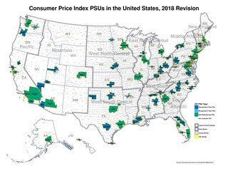
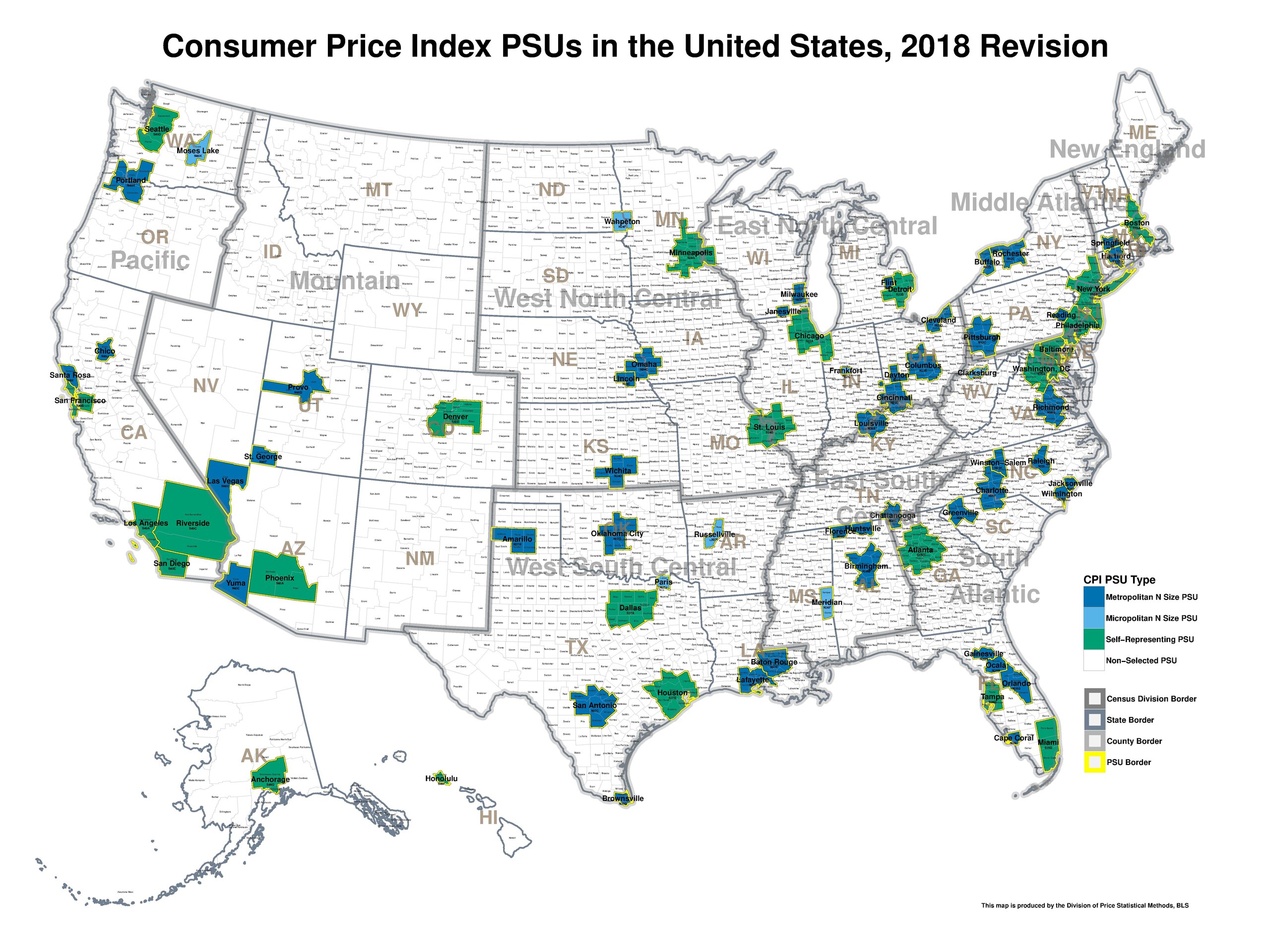
Map of areas sampled for use in the United States Consumer Price Index.
Summary[edit]
| Description |
English: Map of areas sampled for use in the United States Consumer Price Index. Areas in green are large metropolitan areas (or Anchorage, Alaska and Honolulu, Hawaii), whose price changes represent only price changes in those areas. Areas in light or dark blue represent areas whose price changes represent themselves as well as other urban areas (not pictured); in other words, the price changes in those other urban areas are not measured, but are imputed (assumed) to equal the price changes measured in a dark blue or light blue area that is deemed to be similar. The image does not show the concordance between the non-priced areas and the corresponding priced area from where the imputation is sourced. |
| Date | |
| Source | https://www.bls.gov/cpi/additional-resources/geographic-revision-map.pdf |
| Author | United States Bureau of Labor Statistics |
Licensing[edit]
This work is in the public domain in the United States because it is a work prepared by an officer or employee of the United States Government as part of that person’s official duties under the terms of Title 17, Chapter 1, Section 105 of the US Code.
Note: This only applies to original works of the Federal Government and not to the work of any individual U.S. state, territory, commonwealth, county, municipality, or any other subdivision. This template also does not apply to postage stamp designs published by the United States Postal Service since 1978. (See § 313.6(C)(1) of Compendium of U.S. Copyright Office Practices). It also does not apply to certain US coins; see The US Mint Terms of Use.
|
 | |
| This file has been identified as being free of known restrictions under copyright law, including all related and neighboring rights. | ||
File history
Click on a date/time to view the file as it appeared at that time.
| Date/Time | Thumbnail | Dimensions | User | Comment | |
|---|---|---|---|---|---|
| current | 02:25, 13 July 2023 |  | 6,000 × 4,500 (1.41 MB) | QueensanditsCrazy (talk | contribs) | Uploaded a work by United States Bureau of Labor Statistics from https://www.bls.gov/cpi/additional-resources/geographic-revision-map.pdf with UploadWizard |
You cannot overwrite this file.
File usage on Commons
There are no pages that use this file.