File:Bosnie et Sandjak 1904.svg
Jump to navigation
Jump to search

Size of this PNG preview of this SVG file: 657 × 600 pixels. Other resolutions: 263 × 240 pixels | 526 × 480 pixels | 841 × 768 pixels | 1,122 × 1,024 pixels | 2,243 × 2,048 pixels | 2,000 × 1,826 pixels.
Original file (SVG file, nominally 2,000 × 1,826 pixels, file size: 139 KB)
Captions
Captions
Add a one-line explanation of what this file represents
Summary[edit]
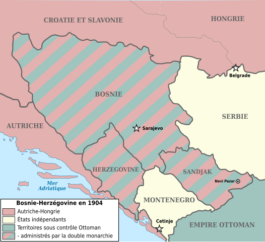
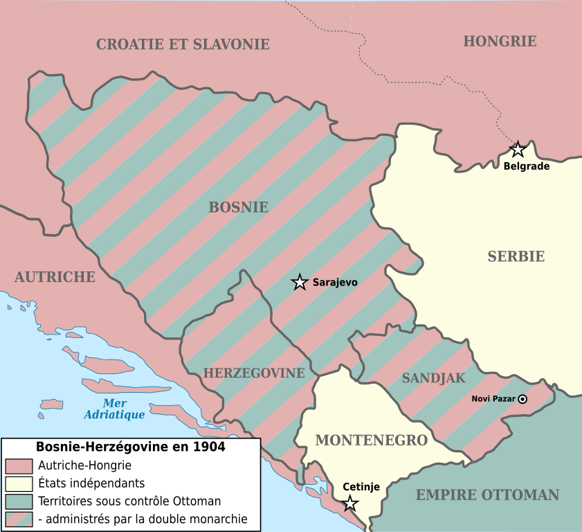
| Description | Map showing Bosnia-Herzegovina and the Sanjak of Novibazar (1904). |
| Date | (UTC) |
| Source | |
| Author |
|
| Other versions |
Derivative works of this file: |
| This is a retouched picture, which means that it has been digitally altered from its original version. The original can be viewed here: Bosnia-Herzegovina and Sanjak of Novibazar.JPG:
|

|
Permission is granted to copy, distribute and/or modify this document under the terms of the GNU Free Documentation License, Version 1.2 or any later version published by the Free Software Foundation; with no Invariant Sections, no Front-Cover Texts, and no Back-Cover Texts. A copy of the license is included in the section entitled GNU Free Documentation License. |
| This file is licensed under the Creative Commons Attribution-Share Alike 3.0 Unported license. | ||
| ||
| This licensing tag was added to this file as part of the GFDL licensing update. |
Original upload log[edit]
This image is a derivative work of the following images:
- Image:Bosnia-Herzegovina_and_Sanjak_of_Novibazar.JPG licensed with PD-US
- 2008-07-29T10:34:31Z Rcbutcher 5696x5200 (17763428 Bytes) {{Information |Description=Map showing Bosnia-Herzegovina and the Sanjak of Novibazar. |Source=The Century Dictionary and Cyclopedia, Vol X, Map No. 89, Copyright 1897 and 1902; Cyclopedia itself, Copyright 1889, 1890, 1891..
Uploaded with derivativeFX
File history
Click on a date/time to view the file as it appeared at that time.
| Date/Time | Thumbnail | Dimensions | User | Comment | |
|---|---|---|---|---|---|
| current | 16:34, 1 January 2018 | | 2,000 × 1,826 (139 KB) | Flappiefh (talk | contribs) | Police DejaVu uniformisée, frontières inter-états plus marquées, changement du titre en légende. |
| 15:25, 30 December 2017 |  | 2,000 × 1,826 (129 KB) | Flappiefh (talk | contribs) | Modification apportées à la demande du Conteur (https://fr.wikipedia.org/wiki/Utilisateur:Conteur-momentanement-indisponible) via l'Atelier Cartes. Au programme : légende refaite, frontières en gris, Dalmatie remplacée par Autriche, une frontière... | |
| 20:39, 2 May 2013 |  | 2,000 × 1,826 (82 KB) | Fulvio314 (talk | contribs) | Removed black artifact (Inkscape issue) | |
| 14:31, 29 December 2012 |  | 2,000 × 1,826 (108 KB) | Ciaurlec (talk | contribs) | Moved Dynamic text to simple text | |
| 08:03, 30 May 2009 |  | 2,000 × 1,826 (109 KB) | Le serbe (talk | contribs) | (ajoute légende des états "avant blanc"(Serbie, Monténégro) La Hongrie n'est pas l'Autriche-Hongrie mais juste la Hongrie. L'Albanie et la Macédoine ne sont pas, la Turquie. La Turquie n'existe pas à l'époque, on parle d'empire ottoman. ) | |
| 08:02, 30 May 2009 |  | 2,000 × 1,826 (109 KB) | Le serbe (talk | contribs) | ajoute légende des états "avant blanc"(Serbie, Monténégro) La Hongrie n'est pas l'Autriche-Hongrie mais juste la Hongrie. L'Albanie et la Macédoine ne sont pas, la Turquie. La Turquie n'existe pas à l'époque, on parle d'empire ottoman. | |
| 11:59, 16 September 2008 |  | 2,000 × 1,826 (163 KB) | Tinodela (talk | contribs) | {{Information |Description= |Source= |Date= |Author= |Permission= |other_versions= }} | |
| 11:58, 16 September 2008 |  | 2,000 × 1,826 (87 KB) | Tinodela (talk | contribs) | {{Information |Description=Map showing Bosnia-Herzegovina and the Sanjak of Novibazar (1904). |Source=*Image:Bosnia-Herzegovina_and_Sanjak_of_Novibazar.JPG |Date=2008-09-16 11:57 (UTC) |Author=*derivative work: ~~~ *[[:Image:Bosnia-Herzegovina_and_S |
You cannot overwrite this file.
File usage on Commons
The following 8 pages use this file:
File usage on other wikis
The following other wikis use this file:
- Usage on el.wikipedia.org
- Usage on fi.wikipedia.org
- Usage on fr.wikipedia.org
Metadata
Categories:
- World War I origins
- Maps of the history of Montenegro in modern times
- Maps of the history of Bosnia and Herzegovina under Ottoman Empire
- Maps of the history of Herzegovina
- Maps of the history of Sandžak
- SVG political maps of Austria-Hungary
- Maps of vilayets of the Ottoman Empire
- Maps of sanjaks of the Ottoman Empire
- Bosnia Vilayet
- Principality of Montenegro
- The Century Dictionary