File:Bartlesville Sand structure map, north.jpg
Jump to navigation
Jump to search

Size of this preview: 800 × 522 pixels. Other resolutions: 320 × 209 pixels | 640 × 418 pixels | 1,024 × 668 pixels | 1,421 × 927 pixels.
Original file (1,421 × 927 pixels, file size: 258 KB, MIME type: image/jpeg)
Captions
Captions
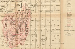
Bartlesville Sand structure map, north
Summary
[edit]
| Description |
English: Bartlesville Sand structure map, north |
| Date | |
| Source | Geologic structure in the Cushing oil and gas field, Oklahoma and its relation to the oil, gas, and water, USGS Bulletin 658, https://pubs.er.usgs.gov/publication/b658 |
| Author | Carl Hugh Beal |
Licensing
[edit]
This image is in the public domain in the United States because it only contains materials that originally came from the United States Geological Survey, an agency of the United States Department of the Interior. For more information, see the official USGS copyright policy.
|
File history
Click on a date/time to view the file as it appeared at that time.
| Date/Time | Thumbnail | Dimensions | User | Comment | |
|---|---|---|---|---|---|
| current | 22:21, 21 July 2020 | | 1,421 × 927 (258 KB) | Pi3.124 (talk | contribs) | Uploaded a work by Carl Hugh Beal from Geologic structure in the Cushing oil and gas field, Oklahoma and its relation to the oil, gas, and water, USGS Bulletin 658, https://pubs.er.usgs.gov/publication/b658 with UploadWizard |
You cannot overwrite this file.
File usage on Commons
There are no pages that use this file.
File usage on other wikis
The following other wikis use this file:
- Usage on en.wikipedia.org