File:An accurate map of the Holy Land Divided into the XII Tribes of Israel. Accomodated to Sacred History, & describing the Travels of Jesus Christ. LOC 99466739.jpg
Jump to navigation
Jump to search

Size of this preview: 436 × 599 pixels. Other resolutions: 174 × 240 pixels | 349 × 480 pixels | 559 × 768 pixels | 745 × 1,024 pixels | 1,490 × 2,048 pixels | 3,239 × 4,452 pixels.
Original file (3,239 × 4,452 pixels, file size: 2.64 MB, MIME type: image/jpeg)
Captions
Captions
Add a one-line explanation of what this file represents
Summary
[edit]| Description |
English: Available also through the Library of Congress web site as a raster image. |
||
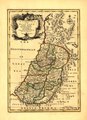
| Title | An accurate map of the Holy Land Divided into the XII Tribes of Israel. Accomodated to Sacred History, & describing the Travels of Jesus Christ. | ||
| Shelf ID | G7500 1752 .B6 TIL | ||
| Date | |||
| Source | https://www.loc.gov/item/99466739/ | ||
| Author | Bowen, Emanuel | ||
| Permission (Reusing this file) |
|
||
| Other versions |
|
||
| Location | Palestine | ||
| Part of | American Memory · General Maps · Catalog · Geography And Map Division | ||
| Subject | Palestine · Maps |

Licensing
[edit]
|
This is a faithful photographic reproduction of a two-dimensional, public domain work of art. The work of art itself is in the public domain for the following reason:
The official position taken by the Wikimedia Foundation is that "faithful reproductions of two-dimensional public domain works of art are public domain".
This photographic reproduction is therefore also considered to be in the public domain in the United States. In other jurisdictions, re-use of this content may be restricted; see Reuse of PD-Art photographs for details. | ||||
File history
Click on a date/time to view the file as it appeared at that time.
| Date/Time | Thumbnail | Dimensions | User | Comment | |
|---|---|---|---|---|---|
| current | 04:55, 21 May 2018 | | 3,239 × 4,452 (2.64 MB) | Fæ (talk | contribs) | LOC Maps https://www.loc.gov/item/99466739/ #12650 |
You cannot overwrite this file.
File usage on Commons
The following 3 pages use this file: