File:Americae pars, nunc Virginia dicta - primum ab Anglis inuenta, sumtibus Dn. Walteri Raleigh, Equestris ordinis Viri, Anno Dni. MDLXXXV regni Vero Sereniss. nostrae Reginae Elisabethae XXVII, hujus NYPL434979.tiff
Jump to navigation
Jump to search

Size of this JPG preview of this TIF file: 780 × 599 pixels. Other resolutions: 312 × 240 pixels | 625 × 480 pixels | 1,000 × 768 pixels | 1,280 × 984 pixels | 2,560 × 1,967 pixels | 4,340 × 3,335 pixels.
Original file (4,340 × 3,335 pixels, file size: 41.44 MB, MIME type: image/tiff)
Captions
Captions
Add a one-line explanation of what this file represents
Summary[edit]
| Description | Americae pars, nunc Virginia dicta : primum ab Anglis inuenta, sumtibus Dn. Walteri Raleigh, Equestris ordinis Viri, Anno Dni. MDLXXXV regni Vero Sereniss. nostrae Reginae Elisabethae XXVII, hujus vero Historia peculiari Libro descripta est, additis etiam Indigenarum Iconibus / autore Ioanne With ; sculptore Theodoro de Bry, qui et. excud. | |||||||||||||||||||||||
| Notes | Appears in Thomas Harriot's A briefe and true report of the new found land of Virginia, 1590. Note 2.) Covers coastal region from Chesapeake Bay to Cape Lookout. Note 3.) Includes ill. Note 4.) John H. Levine Bequest. Note 5.) NYPL copy hand col. Note 6.) Oriented with north to the right. Note 7.) Relief shown pictorially and by hachures. Note 8.) Shows Indian villages. Note 9.) Watermark. Note 10.) National Endowment for the Humanities Grant for Access to Early Maps of the Middle Atlantic Seaboard. | |||||||||||||||||||||||
| Standard reference | Cumming, W.P. Southeast in early maps, 12; Phillips. Maps of America, p. 977 | |||||||||||||||||||||||
| Physical description | 1 map ; 29 x 40 cm. | |||||||||||||||||||||||
| Catalog Call Number | Map Div. 97-7398 [Levine] | |||||||||||||||||||||||
| Date | circa 1590 | |||||||||||||||||||||||
| Source |
http://digitalgallery.nypl.org/nypldigital/dgkeysearchdetail.cfm?imageID=434979
|
|||||||||||||||||||||||
| Author | Bry, Theodor de, 1528-1598 -- Engraver ;White, John, fl. 1585-1593 -- Author | |||||||||||||||||||||||
| Permission (Reusing this file) |
From The Lionel Pincus & Princess Firyal Map Division. Released on a CC0 license.[1] | |||||||||||||||||||||||
| Digital ID | 434979 | |||||||||||||||||||||||
| Location | Stephen A. Schwarzman Building / The Lionel Pincus and Princess Firyal Map Division | |||||||||||||||||||||||
| NYPL digital item published | 2-26-2005; updated 3-25-2011 | |||||||||||||||||||||||

Licensing[edit]
| This file is made available under the Creative Commons CC0 1.0 Universal Public Domain Dedication. | |
| The person who associated a work with this deed has dedicated the work to the public domain by waiving all of their rights to the work worldwide under copyright law, including all related and neighboring rights, to the extent allowed by law. You can copy, modify, distribute and perform the work, even for commercial purposes, all without asking permission.
|
The making of this file was supported by Wikimedia UK.
To see other files made with the support of Wikimedia UK, please see the category Supported by Wikimedia UK.
|
File history
Click on a date/time to view the file as it appeared at that time.
| Date/Time | Thumbnail | Dimensions | User | Comment | |
|---|---|---|---|---|---|
| current | 22:20, 3 May 2014 |  | 4,340 × 3,335 (41.44 MB) | Fæ (talk | contribs) | crop, remove colour profile (uploaded using chunked upload script) |
| 22:54, 4 April 2014 | 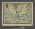 | 4,868 × 4,097 (57.07 MB) | Fæ (talk | contribs) | =={{int:filedesc}}== {{NYPL_map |digital_id = 434979 |standard_reference = Cumming, W.P. Southeast in early maps, 12; Phillips. Maps of America, p. 977 |record_id = 253611 |catalog_call_number = Map Div. 97-7398 [Levine] |item_physical_description = 1... |
You cannot overwrite this file.
File usage on Commons
The following 2 pages use this file: