File:AERIAL VIEW NORTHEAST SHOWING PIERS 17 AND 18 - South Street Seaport, Piers 17 and 18, South Street into East River at Fulton Street, New York, New York County, NY HAER NY,31-NEYO,145A-1.tif
Jump to navigation
Jump to search

Size of this JPG preview of this TIF file: 754 × 600 pixels. Other resolutions: 302 × 240 pixels | 603 × 480 pixels | 965 × 768 pixels | 1,280 × 1,019 pixels | 2,560 × 2,037 pixels | 4,998 × 3,977 pixels.
Original file (4,998 × 3,977 pixels, file size: 18.96 MB, MIME type: image/tiff)
Captions
Captions
Add a one-line explanation of what this file represents
Summary[edit]
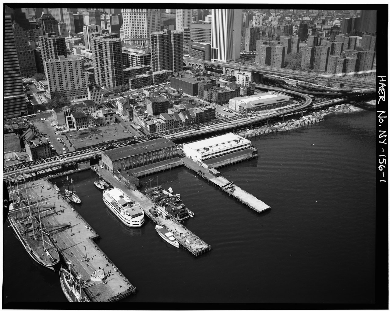
| AERIAL VIEW NORTHEAST SHOWING PIERS 17 AND 18 - South Street Seaport, Piers 17 and 18, South Street into East River at Fulton Street, New York, New York County, NY | ||||
|---|---|---|---|---|
| Photographer |
Related names:
|
|||
| Title |
AERIAL VIEW NORTHEAST SHOWING PIERS 17 AND 18 - South Street Seaport, Piers 17 and 18, South Street into East River at Fulton Street, New York, New York County, NY |
|||
| Depicted place | New York; New York County; New York | |||
| Date | 1975 or later; Documentation compiled after 1968 | |||
| Dimensions | height: 4 in (10.1 cm); width: 5 in (12.7 cm) | |||
| Current location |
Library of Congress Prints and Photographs Division Washington, D.C. 20540 USA http://hdl.loc.gov/loc.pnp/pp.print |
|||
| Accession number |
HAER NY,31-NEYO,145A-1 |
|||
| Credit line |
|
|||
| Notes |
image probably from the early 1950s, as the FDR Drive is a building site here and it was finished 1954 according to the english Wikipedia
|
|||
| Source | https://www.loc.gov/pictures/item/ny1390.photos.118847p | |||
| Permission (Reusing this file) |
|
|||

| Object location | | View this and other nearby images on: OpenStreetMap |
|---|
Confuzius Plaza was finished 1975, so image must be 1975 or later.
| Annotations | This image is annotated: View the annotations at Commons |
File history
Click on a date/time to view the file as it appeared at that time.
| Date/Time | Thumbnail | Dimensions | User | Comment | |
|---|---|---|---|---|---|
| current | 17:16, 29 July 2014 |  | 4,998 × 3,977 (18.96 MB) | Fæ (talk | contribs) | GWToolset: Creating mediafile for Fæ. HABS 24 July 2014 (2301:2600) |
You cannot overwrite this file.
File usage on Commons
The following page uses this file:
Metadata
Categories:
- 375 Pearl Street
- Fulton Market Building
- Royal Insurance Building (Manhattan)
- 200 Water Street
- One Pace Plaza
- Confucius Plaza
- Manhattan Municipal Building
- American Tract Society Building 150 Nassau Street
- St. Margaret's House (Manhattan)
- Southbridge Towers
- Alfred E. Smith Houses
- Murry Bergtraum High School
- Thurgood Marshall United States Courthouse
- One Police Plaza
- Emigrant Industrial Savings Bank Building
- Schermerhorn Row Block
- Franklin D. Roosevelt East River Drive
- Brooklyn Bridge in the 1950s
- Pier 16 (Manhattan)
- Pier 17 (Manhattan)
- Pier 18 (Manhattan)
- Ambrose (ship, 1907)
- Peking (ship, 1911) in New York