File:3.PzDiv - Gefechtsabschnitt.pdf
Jump to navigation
Jump to search

Size of this JPG preview of this PDF file: 800 × 428 pixels. Other resolutions: 320 × 171 pixels | 640 × 342 pixels | 1,024 × 548 pixels | 1,697 × 908 pixels.
Original file (1,697 × 908 pixels, file size: 3.47 MB, MIME type: application/pdf)
Captions
Captions
Add a one-line explanation of what this file represents

|
This file has been superseded by 3.PzDiv - Gefechtsabschnitt.svg. It is recommended to use the other file. Please note that deleting superseded images requires consent.
|

|
Summary[edit]
| Description |
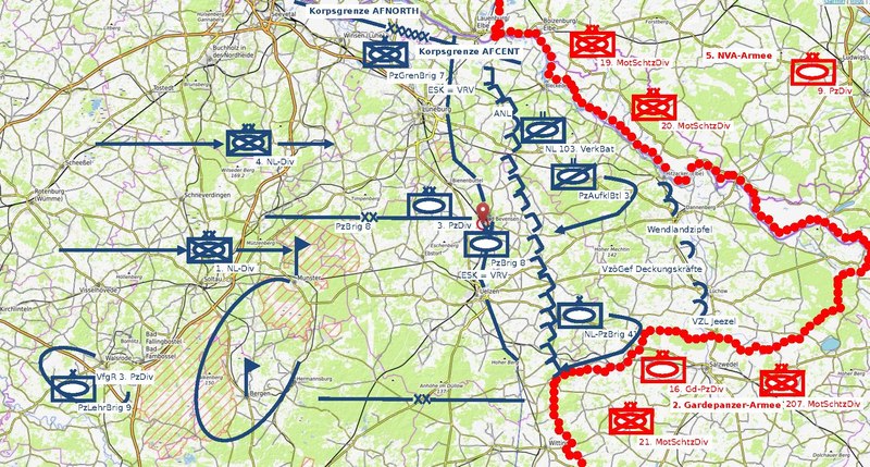
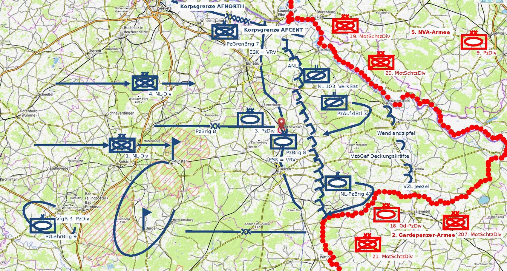
Deutsch: 3. PzDiv GefAbschnitt – taktische Karte. Deckungsabschnitt der 3. Panzerdivision im Gefechtsabschnitt des I. NL-Korps (Eerste Legerkorps), um Aufmarsch der 4. und 1. NL-Division am vorderen Rand der Verteidigun (VRV) zu decken |
| Date | |
| Source | OpenStreetMap + OpenTopoMap |
| Author | Graf zu Pappenheim |
Licensing[edit]
| This file is made available under the Creative Commons CC0 1.0 Universal Public Domain Dedication. | |
| The person who associated a work with this deed has dedicated the work to the public domain by waiving all of their rights to the work worldwide under copyright law, including all related and neighboring rights, to the extent allowed by law. You can copy, modify, distribute and perform the work, even for commercial purposes, all without asking permission.
|
This file is licensed under the Creative Commons Attribution-Share Alike 3.0 Unported license.
- You are free:
- to share – to copy, distribute and transmit the work
- to remix – to adapt the work
- Under the following conditions:
- attribution – You must give appropriate credit, provide a link to the license, and indicate if changes were made. You may do so in any reasonable manner, but not in any way that suggests the licensor endorses you or your use.
- share alike – If you remix, transform, or build upon the material, you must distribute your contributions under the same or compatible license as the original.
| This work contains information from OpenStreetMap, which is made available under the Open Database License (ODbL).
The ODbL does not require any particular license for maps produced from ODbL data. Prior to 1 August 2020, map tiles produced by the OpenStreetMap Foundation were licensed under the CC-BY-SA-2.0 license. Maps produced by other people may be subject to other licences. |
File history
Click on a date/time to view the file as it appeared at that time.
| Date/Time | Thumbnail | Dimensions | User | Comment | |
|---|---|---|---|---|---|
| current | 10:30, 10 March 2022 |  | 1,697 × 908 (3.47 MB) | Sebastian Wallroth (talk | contribs) | cropped; text converted |
| 03:15, 23 December 2021 |  | 1,752 × 1,239 (482 KB) | Graf zu Pappenheim (talk | contribs) | {{Information |Beschreibung = 3. PzDiv GefAbschnitt |Quelle = Open Topo Map |Urheber = Graf zu Pappenheim |Datum = 23.12.2021 |Genehmigung = Public Domain |Andere Versionen = |Anmerkungen = Open Topo Map is public domain }} |
You cannot overwrite this file.
File usage on Commons
The following 2 pages use this file: