File:1981-06-11 Golbaf, Iran earthquake shakemap.jpg
Jump to navigation
Jump to search

Size of this preview: 470 × 599 pixels. Other resolutions: 188 × 240 pixels | 376 × 480 pixels | 785 × 1,001 pixels.
Original file (785 × 1,001 pixels, file size: 372 KB, MIME type: image/jpeg)
Captions
Captions
Add a one-line explanation of what this file represents
Summary[edit]
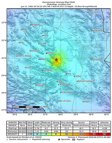
| Description | USGS ShakeMap of the 1981 Golbaf earthquake | |||
| Date | ||||
| Source | https://earthquake.usgs.gov/earthquakes/eventpage/usp0001e35/shakemap/intensity | |||
| Author | United States Geological Survey | |||
| Permission (Reusing this file) |
|
File history
Click on a date/time to view the file as it appeared at that time.
| Date/Time | Thumbnail | Dimensions | User | Comment | |
|---|---|---|---|---|---|
| current | 12:55, 4 June 2021 | | 785 × 1,001 (372 KB) | IllCom (talk | contribs) | {{Information |Description=USGS ShakeMap of the 1981 Golbaf earthquake |Source=https://earthquake.usgs.gov/earthquakes/eventpage/usp0001e35/shakemap/intensity |Date=2020-06-03 |Author=United States Geological Survey |Permission={{PD-USGov-USGS}} |other_versions= }} Category:ShakeMaps of earthquakes in Iran |
You cannot overwrite this file.
File usage on Commons
There are no pages that use this file.
File usage on other wikis
The following other wikis use this file:
- Usage on de.wikipedia.org