| Name
|
Heritage list
|
Place
|
Street address
|
Coordinates
|
place_id
|
Image
|
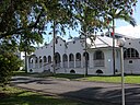
| Mango Avenue, Eimeo (Q22569831)
|
listed on the Queensland Heritage Register
|
|
|
21°02′10″S 149°10′32″E / 21.036°S 149.1756°E / -21.036; 149.1756
|
602553
|

|
| Manly Retaining Wall (Q19875366)
|
listed on the Queensland Heritage Register
|
|
|
27°27′30″S 153°11′10″E / 27.4583°S 153.186°E / -27.4583; 153.186
|
602039
|

|
| Manly War Memorial (Q18639489)
|
listed on the Queensland Heritage Register
|
|
|
27°27′20″S 153°10′59″E / 27.4555°S 153.183°E / -27.4555; 153.183
|
600249
|

|
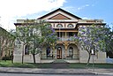
| Manor Apartment Hotel (Q6751307)
|
listed on the Queensland Heritage Register
|
|
|
27°28′03″S 153°01′41″E / 27.4676°S 153.028°E / -27.4676; 153.028
|
600150
|

|
| Marburg Community Centre and First World War Memorial (Q19875376)
|
listed on the Queensland Heritage Register
|
|
|
27°33′57″S 152°35′46″E / 27.5659°S 152.596°E / -27.5659; 152.596
|
600733
|

|
| Marburg Hotel (Q19875377)
|
listed on the Queensland Heritage Register
|
|
|
27°33′57″S 152°35′49″E / 27.5659°S 152.597°E / -27.5659; 152.597
|
600732
|

|
| Marburg State School (Q48808343)
|
listed on the Queensland Heritage Register
|
|
|
27°33′41″S 152°35′36″E / 27.5615°S 152.5932°E / -27.5615; 152.5932
|
650002
|

|
| Mareeba Shire Hall (Q24883826)
|
listed on the Queensland Heritage Register
|
|
|
16°59′30″S 145°25′23″E / 16.9918°S 145.4231°E / -16.9918; 145.4231
|
601553
|

|
| Marist Brothers College Rosalie Buildings (Q28220470)
|
listed on the Queensland Heritage Register
|
|
|
27°27′50″S 152°59′58″E / 27.4639°S 152.9994°E / -27.4639; 152.9994
|
602607
|

|
| Maroon State School and Maroon War Memorial (Q48815098)
|
listed on the Queensland Heritage Register
|
|
|
28°10′19″S 152°42′49″E / 28.172°S 152.7136°E / -28.172; 152.7136
|
650004
|

|
| Mary Valley Railway Cream Sheds (Q24090188)
|
listed on the Queensland Heritage Register
|
|
|
26°21′59″S 152°40′07″E / 26.3664°S 152.6685°E / -26.3664; 152.6685
|
602792
|
|
| Mary Watson's Monument (Q24998016)
|
listed on the Queensland Heritage Register
|
|
|
15°27′58″S 145°14′59″E / 15.4662°S 145.2496°E / -15.4662; 145.2496
|
600421
|

|
| Maryborough Base Hospital (Q24090206)
|
listed on the Queensland Heritage Register
|
|
|
25°31′20″S 152°41′25″E / 25.5223°S 152.6902°E / -25.5223; 152.6902
|
601907
|

|
| Maryborough Boys Grammar School Building (Q30626448)
|
listed on the Queensland Heritage Register
|
|
|
25°32′01″S 152°41′55″E / 25.5337°S 152.6986°E / -25.5337; 152.6986
|
600697
|

|
| Maryborough Central State School (Q6781150)
|
listed on the Queensland Heritage Register
|
|
|
25°32′07″S 152°42′00″E / 25.53517778°S 152.7°E / -25.53517778; 152.7
|
601264
|

|
| Maryborough City Hall (Q24090208)
|
listed on the Queensland Heritage Register
|
|
|
25°32′16″S 152°42′06″E / 25.5378°S 152.7017°E / -25.5378; 152.7017
|
600698
|
|
| Maryborough Courthouse (Q6781152)
|
listed on the Queensland Heritage Register
|
|
|
25°32′23″S 152°42′14″E / 25.539611111111°S 152.70395833333°E / -25.539611111111; 152.70395833333
|
600714
|
|
| Maryborough Government Office Building (Q24090210)
|
listed on the Queensland Heritage Register
|
|
|
25°32′16″S 152°42′18″E / 25.5379°S 152.705°E / -25.5379; 152.705
|
600713
|

|
| Maryborough Heritage Centre (Q24090209)
|
listed on the Queensland Heritage Register
|
|
|
25°32′19″S 152°42′17″E / 25.5385°S 152.7047°E / -25.5385; 152.7047
|
600711
|

|
| Maryborough School of Arts (Q24090211)
|
listed on the Queensland Heritage Register
|
|
|
25°32′14″S 152°42′09″E / 25.5373°S 152.7024°E / -25.5373; 152.7024
|
600701
|

|
| Maryborough Waterside Workers' Hall (Q23035504)
|
listed on the Queensland Heritage Register
|
|
|
25°32′21″S 152°42′21″E / 25.5392°S 152.7058°E / -25.5392; 152.7058
|
600717
|

|
| Maryborough railway station, Queensland (Q19875397)
|
listed on the Queensland Heritage Register
|
|
|
25°32′19″S 152°42′00″E / 25.5385°S 152.7°E / -25.5385; 152.7
|
600702
|

|
| Masel Residence (Q24089830)
|
listed on the Queensland Heritage Register
|
|
|
28°39′09″S 151°56′18″E / 28.6524°S 151.9384°E / -28.6524; 151.9384
|
601552
|

|
| Masonic Temple, Brisbane (Q16237973)
|
listed on the Queensland Heritage Register
|
|
|
27°27′54″S 153°01′41″E / 27.465°S 153.028°E / -27.465; 153.028
|
600074
|

|
| Mayes Cottage (Q6797092)
|
listed on the Queensland Heritage Register
|
|
|
27°39′09″S 153°07′01″E / 27.6526°S 153.117°E / -27.6526; 153.117
|
600662
|

|
| Maytown (Q6798042)
|
listed on the Queensland Heritage Register
|
|
|
16°03′00″S 144°16′59″E / 16.05°S 144.283°E / -16.05; 144.283
|
602255
|

|
| McCowat's Farm (Q24190251)
|
listed on the Queensland Heritage Register
|
|
|
17°27′39″S 145°59′01″E / 17.4609°S 145.9836°E / -17.4609; 145.9836
|
600632
|
|
| McDonnell & East Ltd Building (Q19875425)
|
listed on the Queensland Heritage Register
|
|
|
27°28′06″S 153°01′12″E / 27.4683°S 153.02°E / -27.4683; 153.02
|
600120
|

|
| McLeod Street Pioneer Cemetery (Q22919907)
|
listed on the Queensland Heritage Register
|
|
|
16°54′56″S 145°45′51″E / 16.9156°S 145.7643°E / -16.9156; 145.7643
|
600383
|

|
| McWhinneys Brick Cottage (Q19875479)
|
listed on the Queensland Heritage Register
|
|
|
27°27′48″S 153°01′19″E / 27.4634°S 153.022°E / -27.4634; 153.022
|
602248
|

|
| McWhirters (Q6802771)
|
listed on the Queensland Heritage Register
|
|
|
27°27′27″S 153°02′02″E / 27.4574°S 153.034°E / -27.4574; 153.034
|
600214
|

|
| Meatworks and Wharf Site, St Lawrence (Q24185663)
|
listed on the Queensland Heritage Register
|
|
|
22°22′33″S 149°33′54″E / 22.3758°S 149.565°E / -22.3758; 149.565
|
601173
|

|
| Mellors Drapery and Haberdashery (Q28184053)
|
listed on the Queensland Heritage Register
|
|
|
25°37′31″S 151°36′35″E / 25.6254°S 151.6097°E / -25.6254; 151.6097
|
601470
|

|
| Men's Toilet, Russell Street, Toowoomba (Q18390536)
|
listed on the Queensland Heritage Register
|
|
|
27°33′32″S 151°57′07″E / 27.559°S 151.952°E / -27.559; 151.952
|
601381
|

|
| Meringa Sugar Experiment Station (Q48804632)
|
listed on the Queensland Heritage Register
|
|
|
17°04′06″S 145°46′26″E / 17.0683°S 145.7738°E / -17.0683; 145.7738
|
602835
|

|
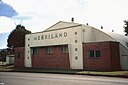
| Merriland Hall (Q24884389)
|
listed on the Queensland Heritage Register
|
|
|
17°16′07″S 145°28′57″E / 17.2685°S 145.4826°E / -17.2685; 145.4826
|
602016
|
|
| Metro Arts Theatre (Q6824486)
|
listed on the Queensland Heritage Register
|
|
|
27°28′12″S 153°01′44″E / 27.4701°S 153.029°E / -27.4701; 153.029
|
600090
|

|
| Michael Gannon residence (Q19875622)
|
listed on the Queensland Heritage Register
|
|
|
27°27′08″S 153°11′02″E / 27.4522°S 153.184°E / -27.4522; 153.184
|
601904
|

|
| Middenbury House (Q18011851)
|
listed on the Queensland Heritage Register
|
|
|
27°29′05″S 152°59′46″E / 27.4846°S 152.996°E / -27.4846; 152.996
|
600330
|

|
| Miegunyah (Q19875627)
|
listed on the Queensland Heritage Register
|
|
|
27°26′44″S 153°02′28″E / 27.4455°S 153.041°E / -27.4455; 153.041
|
600055
|
|
| Mihi Creek heritage site (Q22329521)
|
listed on the Queensland Heritage Register
|
|
|
27°35′36″S 152°45′13″E / 27.5932°S 152.7536°E / -27.5932; 152.7536
|
645610
|
|
| Mill Point Settlement Site (Q24090152)
|
listed on the Queensland Heritage Register
|
|
|
26°14′52″S 153°00′00″E / 26.2478°S 153.0001°E / -26.2478; 153.0001
|
601280
|

|
| Millaa Millaa Falls (Q3652628)
|
listed on the Queensland Heritage Register
|
Far North Queensland
|
|
17°29′44″S 145°36′36″E / 17.495555555556°S 145.61°E / -17.495555555556; 145.61
|
602449
|

|
| Millbrook, Toowoomba (Q18390684)
|
listed on the Queensland Heritage Register
|
|
|
27°33′51″S 151°57′32″E / 27.5643°S 151.959°E / -27.5643; 151.959
|
601310
|

|
| Milton House, Milton (Q19875656)
|
listed on the Queensland Heritage Register
|
|
|
27°28′18″S 153°00′22″E / 27.4717°S 153.006°E / -27.4717; 153.006
|
600253
|

|
| Milton State School (Q48815946)
|
listed on the Queensland Heritage Register
|
|
|
27°28′02″S 152°59′56″E / 27.4672°S 152.9989°E / -27.4672; 152.9989
|
650049
|

|
| Mining works on Towers Hill (Q24896094)
|
listed on the Queensland Heritage Register
|
|
|
20°05′21″S 146°15′06″E / 20.0893°S 146.2517°E / -20.0893; 146.2517
|
601851
|

|
| Mirani railway station, Queensland (Q22329522)
|
listed on the Queensland Heritage Register
|
|
|
21°09′33″S 148°51′52″E / 21.1591°S 148.8644°E / -21.1591; 148.8644
|
600984
|

|
| Miriam Vale War Memorial (Q23003019)
|
listed on the Queensland Heritage Register
|
|
|
24°19′45″S 151°33′48″E / 24.3293°S 151.5633°E / -24.3293; 151.5633
|
600725
|

|
| Mitchell State School (1914 Building) (Q28183814)
|
listed on the Queensland Heritage Register
|
|
|
26°29′17″S 147°58′17″E / 26.488°S 147.9713°E / -26.488; 147.9713
|
601076
|
|
| Mitchell War Memorial (Q23003022)
|
listed on the Queensland Heritage Register
|
|
|
26°29′21″S 147°58′18″E / 26.4892°S 147.9718°E / -26.4892; 147.9718
|
600038
|

|
| Mitchell railway station (Q14935497)
|
listed on the Queensland Heritage Register
|
|
|
26°29′14″S 147°58′07″E / 26.4872°S 147.9687°E / -26.4872; 147.9687
|
601077
|
|
| Mitchelton State School (Q83230797)
|
listed on the Queensland Heritage Register
|
|
|
|
650063
|
|
| Monier Ventilation Shaft 1 (Q19875715)
|
listed on the Queensland Heritage Register
|
|
|
27°27′46″S 153°01′16″E / 27.4629°S 153.021°E / -27.4629; 153.021
|
601995
|
|
| Monier Ventilation Shaft 2 (Q19875716)
|
listed on the Queensland Heritage Register
|
|
|
27°27′35″S 153°01′41″E / 27.4596°S 153.028°E / -27.4596; 153.028
|
602067
|

|
| Monier Ventilation Shaft 3 (Q19875718)
|
listed on the Queensland Heritage Register
|
|
|
27°27′21″S 153°02′56″E / 27.4558°S 153.049°E / -27.4558; 153.049
|
602068
|

|
| Monkland State School Residence (Q24090069)
|
listed on the Queensland Heritage Register
|
|
|
26°12′46″S 152°41′14″E / 26.2129°S 152.6871°E / -26.2129; 152.6871
|
602013
|

|
| Monkton (Q17014216)
|
listed on the Queensland Heritage Register
|
|
|
27°32′42″S 152°58′30″E / 27.545109°S 152.974901°E / -27.545109; 152.974901
|
601170
|
|
| Monsildale Homestead (Q24089939)
|
listed on the Queensland Heritage Register
|
|
|
26°42′19″S 152°23′52″E / 26.705216°S 152.397667°E / -26.705216; 152.397667
|
602704
|

|
| Montville Memorial Precinct (Q23003028)
|
listed on the Queensland Heritage Register
|
|
|
26°41′18″S 152°53′34″E / 26.6882°S 152.8927°E / -26.6882; 152.8927
|
602616
|

|
| Moody's Cottages (Q19875722)
|
listed on the Queensland Heritage Register
|
|
|
27°27′33″S 153°01′37″E / 27.4593°S 153.027°E / -27.4593; 153.027
|
600314
|

|
| Moonah Creek Hanging Tree (Q28183535)
|
listed on the Queensland Heritage Register
|
Mount Isa
|
|
21°30′11″S 138°55′06″E / 21.503°S 138.9184°E / -21.503; 138.9184
|
600040
|

|
| Mooney Memorial Fountain (Q19875728)
|
listed on the Queensland Heritage Register
|
|
|
27°27′58″S 153°01′48″E / 27.466°S 153.03°E / -27.466; 153.03
|
600087
|

|
| Mooneys Building (Q16895362)
|
listed on the Queensland Heritage Register
|
|
|
27°28′16″S 153°01′41″E / 27.4712°S 153.028°E / -27.4712; 153.028
|
600130
|
|
| Moorlands (Q19817763)
|
listed on the Queensland Heritage Register
|
|
|
27°28′44″S 152°59′56″E / 27.479°S 152.999°E / -27.479; 152.999
|
600052
|

|
| Moorooka State School (Q48815731)
|
listed on the Queensland Heritage Register
|
|
|
27°32′10″S 153°01′26″E / 27.5361°S 153.024°E / -27.5361; 153.024
|
602861
|

|
| Morayfield Plantation (Q24089971)
|
listed on the Queensland Heritage Register
|
|
|
27°06′20″S 153°00′05″E / 27.1055°S 153.0015°E / -27.1055; 153.0015
|
645614
|

|
| Morayfield State School (Q48804745)
|
listed on the Queensland Heritage Register
|
|
|
27°06′23″S 152°56′50″E / 27.1064°S 152.9471°E / -27.1064; 152.9471
|
602839
|

|
| Moreton Central Sugar Mill Cane Tramway (Q22329524)
|
listed on the Queensland Heritage Register
|
|
|
26°37′36″S 152°57′44″E / 26.6267°S 152.9621°E / -26.6267; 152.9621
|
602522
|
|
| Moreton Central Sugar Mill Worker's Housing (Q24089987)
|
listed on the Queensland Heritage Register
|
|
|
26°37′38″S 152°57′30″E / 26.6272°S 152.9582°E / -26.6272; 152.9582
|
602648
|

|
| Morningside Air Raid Shelter (Q19817764)
|
listed on the Queensland Heritage Register
|
|
|
27°28′09″S 153°04′12″E / 27.4691°S 153.07°E / -27.4691; 153.07
|
602481
|

|
| Morningside State School (Q83230737)
|
listed on the Queensland Heritage Register
|
|
|
27°27′52″S 153°03′57″E / 27.4644°S 153.0659°E / -27.4644; 153.0659
|
650057
|
|
| Mortuary Chapel, Maryborough Cemetery (Q24090212)
|
listed on the Queensland Heritage Register
|
|
|
25°30′28″S 152°40′18″E / 25.5079°S 152.6716°E / -25.5079; 152.6716
|
600689
|

|
| Mossman District Hospital (Q24997951)
|
listed on the Queensland Heritage Register
|
|
|
16°27′51″S 145°22′06″E / 16.4643°S 145.3684°E / -16.4643; 145.3684
|
602713
|
|
| Mossman Shire Hall and Douglas Shire Council Chambers (Q24997950)
|
listed on the Queensland Heritage Register
|
|
|
16°27′32″S 145°22′28″E / 16.4589°S 145.3744°E / -16.4589; 145.3744
|
602758
|

|
| Mount Abundance Homestead (Q28183898)
|
listed on the Queensland Heritage Register
|
|
|
26°35′32″S 148°41′47″E / 26.5921°S 148.6965°E / -26.5921; 148.6965
|
600371
|

|
| Mount Carmel Convent (Q18754794)
|
listed on the Queensland Heritage Register
|
|
|
27°26′47″S 153°10′34″E / 27.4464°S 153.176°E / -27.4464; 153.176
|
601730
|

|
| Mount Clara chimney (Q6920154)
|
listed on the Queensland Heritage Register
|
|
|
26°10′34″S 152°16′23″E / 26.1762°S 152.273°E / -26.1762; 152.273
|
600640
|

|
| Mount Coot-tha Forest (Q19875788)
|
listed on the Queensland Heritage Register
|
|
|
27°28′35″S 152°57′07″E / 27.4765°S 152.952°E / -27.4765; 152.952
|
602446
|

|
| Mount Coot-tha Lookout (Q19875790)
|
listed on the Queensland Heritage Register
|
|
|
27°29′05″S 152°57′32″E / 27.4848°S 152.959°E / -27.4848; 152.959
|
601564
|

|
| Mount Cornish Homestead (Q26793372)
|
listed on the Queensland Heritage Register
|
|
|
22°33′14″S 144°36′45″E / 22.5538°S 144.6125°E / -22.5538; 144.6125
|
600009
|

|
| Mount Cuthbert Township and Smelter (Q25641087)
|
listed on the Queensland Heritage Register
|
|
|
19°59′07″S 139°55′11″E / 19.9852°S 139.9197°E / -19.9852; 139.9197
|
601629
|

|
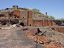
| Mount Elliott Company Metallurgical Plant and Mill (Q25641085)
|
listed on the Queensland Heritage Register
|
|
|
20°43′12″S 140°29′59″E / 20.7199°S 140.4997°E / -20.7199; 140.4997
|
602256
|

|
| Mount Elliott Mining Complex (Q25641091)
|
listed on the Queensland Heritage Register
|
|
|
21°31′58″S 140°30′13″E / 21.5328°S 140.5035°E / -21.5328; 140.5035
|
645612
|
|
| Mount Garnet Mine Assay Office (Q24887331)
|
listed on the Queensland Heritage Register
|
|
|
17°40′44″S 145°06′41″E / 17.679°S 145.1114°E / -17.679; 145.1114
|
600543
|
|
| Mount Isa Mine Early Infrastructure (Q28183530)
|
listed on the Queensland Heritage Register
|
|
|
20°44′01″S 139°28′36″E / 20.7335°S 139.4768°E / -20.7335; 139.4768
|
601182
|

|
| Mount Martin Cane Lift (Q24185667)
|
listed on the Queensland Heritage Register
|
|
|
21°06′53″S 148°48′18″E / 21.1147°S 148.8051°E / -21.1147; 148.8051
|
602750
|

|
| Mount Moran Battery (Q24893361)
|
listed on the Queensland Heritage Register
|
|
|
19°08′28″S 143°29′56″E / 19.1412°S 143.4988°E / -19.1412; 143.4988
|
601921
|

|
| Mount Morgan Cemetery (Q22919912)
|
listed on the Queensland Heritage Register
|
|
|
23°39′28″S 150°23′25″E / 23.6578°S 150.3902°E / -23.6578; 150.3902
|
600753
|

|
| Mount Morgan Central State School (Q22907072)
|
listed on the Queensland Heritage Register
|
|
|
23°38′46″S 150°23′18″E / 23.646°S 150.3883°E / -23.646; 150.3883
|
600747
|

|
| Mount Morgan Court House and Police Station (Q24090288)
|
listed on the Queensland Heritage Register
|
|
|
23°38′54″S 150°23′18″E / 23.6484°S 150.3884°E / -23.6484; 150.3884
|
600745
|

|
| Mount Morgan Masonic Temple (Q24090290)
|
listed on the Queensland Heritage Register
|
|
|
23°38′49″S 150°23′10″E / 23.6469°S 150.3862°E / -23.6469; 150.3862
|
600744
|

|
| Mount Morgan Mine (Q6922260)
|
listed on the Queensland Heritage Register
|
|
|
23°38′28″S 150°22′30″E / 23.6411°S 150.375°E / -23.6411; 150.375
|
600751
|

|
| Mount Morgan School of Arts (Q24090291)
|
listed on the Queensland Heritage Register
|
|
|
23°38′42″S 150°23′12″E / 23.645°S 150.3867°E / -23.645; 150.3867
|
600749
|

|
| Mount Morgan State High School (Q48817931)
|
listed on the Queensland Heritage Register
|
|
|
23°38′37″S 150°23′13″E / 23.6436°S 150.3869°E / -23.6436; 150.3869
|
650005
|

|
| Mount Morgan railway station (Q6922259)
|
listed on the Queensland Heritage Register
|
|
|
23°38′21″S 150°23′13″E / 23.6391°S 150.387°E / -23.6391; 150.387
|
600752
|

|
| Mount Perry Masonic Lodge (Q24189884)
|
listed on the Queensland Heritage Register
|
|
|
25°10′40″S 151°38′37″E / 25.1778°S 151.6437°E / -25.1778; 151.6437
|
600765
|

|
| Mount Perry Powder Magazine (Q28184082)
|
listed on the Queensland Heritage Register
|
|
|
25°08′25″S 151°38′43″E / 25.1403°S 151.6454°E / -25.1403; 151.6454
|
602782
|

|
| Mount St John Anti-Aircraft Battery (Q24189495)
|
listed on the Queensland Heritage Register
|
|
|
19°15′23″S 146°44′34″E / 19.2564°S 146.7428°E / -19.2564; 146.7428
|
602084
|

|
| Mount St Mary's Convent (Q19875821)
|
listed on the Queensland Heritage Register
|
|
|
27°29′11″S 152°59′10″E / 27.4864°S 152.986°E / -27.4864; 152.986
|
601601
|

|
| Mount Tarampa State School (Q48817625)
|
listed on the Queensland Heritage Register
|
|
|
27°27′19″S 152°29′22″E / 27.4553°S 152.4895°E / -27.4553; 152.4895
|
602853
|

|
| Mountview House (Q19817765)
|
listed on the Queensland Heritage Register
|
|
|
27°27′44″S 153°01′19″E / 27.4622°S 153.022°E / -27.4622; 153.022
|
602317
|

|
| Mowbray Park War Memorial (Q19875838)
|
listed on the Queensland Heritage Register
|
|
|
27°28′43″S 153°02′38″E / 27.4785°S 153.044°E / -27.4785; 153.044
|
600189
|

|
| Mowbray Park, Brisbane (Q18166159)
|
listed on the Queensland Heritage Register
|
|
|
27°28′43″S 153°02′38″E / 27.4786°S 153.044°E / -27.4786; 153.044
|
600189
|
|
| Mowbraytown Presbyterian Church (Q19817768)
|
listed on the Queensland Heritage Register
|
|
|
27°28′59″S 153°02′35″E / 27.4831°S 153.043°E / -27.4831; 153.043
|
601219
|

|
| Mrs Watson's Cottage (Q24997977)
|
listed on the Queensland Heritage Register
|
|
|
14°40′00″S 145°27′37″E / 14.6666°S 145.4604°E / -14.6666; 145.4604
|
600430
|

|
| Mulgrave Shire Council Chambers (Q24190704)
|
listed on the Queensland Heritage Register
|
|
|
16°55′17″S 145°46′42″E / 16.9215°S 145.7783°E / -16.9215; 145.7783
|
601913
|

|
| Mungana Archaeological Area (Q24884856)
|
listed on the Queensland Heritage Register
|
|
|
17°06′03″S 144°23′34″E / 17.1009°S 144.3929°E / -17.1009; 144.3929
|
645601
|

|
| Muntapa Tunnel (Q18378280)
|
listed on the Queensland Heritage Register
|
|
|
27°04′33″S 151°44′53″E / 27.0758°S 151.748°E / -27.0758; 151.748
|
602594
|

|
| Muralambeen Homestead (Q24190081)
|
listed on the Queensland Heritage Register
|
|
|
18°41′51″S 146°14′17″E / 18.6976°S 146.238°E / -18.6976; 146.238
|
602362
|

|
| Murgon Civic Centre (Q28183604)
|
listed on the Queensland Heritage Register
|
|
|
26°14′30″S 151°56′31″E / 26.2417°S 151.942°E / -26.2417; 151.942
|
602812
|

|
| Murgon State School (Q48817651)
|
listed on the Queensland Heritage Register
|
|
|
26°14′22″S 151°56′34″E / 26.2394°S 151.9428°E / -26.2394; 151.9428
|
650003
|

|
| Murphys Creek Railway Complex (Q19875917)
|
listed on the Queensland Heritage Register
|
|
|
27°27′49″S 152°03′32″E / 27.4635°S 152.059°E / -27.4635; 152.059
|
601532
|

|
| Murrumba Homestead Grounds (Q24089969)
|
listed on the Queensland Heritage Register
|
|
|
27°15′58″S 152°58′48″E / 27.2661°S 152.9799°E / -27.2661; 152.9799
|
602370
|

|
| Musgrave House (Q19875950)
|
listed on the Queensland Heritage Register
|
|
|
27°19′48″S 153°04′59″E / 27.3299°S 153.083°E / -27.3299; 153.083
|
601499
|

|
| Musgrave Telegraph Station (Q24997984)
|
listed on the Queensland Heritage Register
|
|
|
14°46′57″S 143°29′05″E / 14.7825°S 143.4847°E / -14.7825; 143.4847
|
600431
|

|
| Musket Villa (Q19875960)
|
listed on the Queensland Heritage Register
|
|
|
27°25′54″S 153°04′01″E / 27.4316°S 153.067°E / -27.4316; 153.067
|
601741
|
|
| Mutdapilly State School (Q48804760)
|
listed on the Queensland Heritage Register
|
|
|
27°46′14″S 152°39′03″E / 27.7705°S 152.6507°E / -27.7705; 152.6507
|
602840
|

|
| Myall Park Botanic Garden (Q5926779)
|
listed on the Queensland Heritage Register
|
|
|
27°12′21″S 149°38′56″E / 27.2057°S 149.64891°E / -27.2057; 149.64891
|
602805
|

|
| Myendetta Homestead (Q28184283)
|
listed on the Queensland Heritage Register
|
|
|
26°33′58″S 146°01′22″E / 26.5662°S 146.0228°E / -26.5662; 146.0228
|
602822
|

|
| Naldham House (Q16895636)
|
listed on the Queensland Heritage Register
|
|
|
27°28′12″S 153°01′48″E / 27.4701°S 153.03°E / -27.4701; 153.03
|
600133
|

|
| Nanango Butter Factory Building (Q28184167)
|
listed on the Queensland Heritage Register
|
|
|
26°40′11″S 152°00′12″E / 26.6698°S 152.0034°E / -26.6698; 152.0034
|
602525
|

|
| Nanango Court House (Q28184152)
|
listed on the Queensland Heritage Register
|
|
|
26°40′13″S 152°00′08″E / 26.6704°S 152.0021°E / -26.6704; 152.0021
|
601571
|
|
| Nassagaweya, West End (Q19876034)
|
listed on the Queensland Heritage Register
|
|
|
27°29′17″S 153°00′11″E / 27.4881°S 153.003°E / -27.4881; 153.003
|
600227
|

|
| National Australia Bank (Q19876051)
|
listed on the Queensland Heritage Register
|
|
|
27°28′07″S 153°01′34″E / 27.4687°S 153.026°E / -27.4687; 153.026
|
600141
|

|
| National Australia Bank (Q19876057)
|
listed on the Queensland Heritage Register
|
|
|
27°28′01″S 153°01′41″E / 27.467°S 153.028°E / -27.467; 153.028
|
600153
|

|
| National Australia Bank, Childers (Q24090244)
|
listed on the Queensland Heritage Register
|
|
|
25°14′10″S 152°16′44″E / 25.236°S 152.2788°E / -25.236; 152.2788
|
600616
|

|
| National Bank of Australasia Building, Mossman (Q24997953)
|
listed on the Queensland Heritage Register
|
|
|
16°27′33″S 145°22′30″E / 16.4593°S 145.3749°E / -16.4593; 145.3749
|
601542
|

|
| National Hotel, Warwick (Q20085688)
|
listed on the Queensland Heritage Register
|
|
|
28°13′00″S 152°02′24″E / 28.2168°S 152.04°E / -28.2168; 152.04
|
600950
|

|
| National Mutual Life Building (Q19876084)
|
listed on the Queensland Heritage Register
|
|
|
27°28′03″S 153°01′41″E / 27.4676°S 153.028°E / -27.4676; 153.028
|
600151
|

|
| Naval Offices, Brisbane (Q19876104)
|
listed on the Queensland Heritage Register
|
Brisbane City
|
|
27°28′19″S 153°01′52″E / 27.4719°S 153.031°E / -27.4719; 153.031
27°28′19″S 153°01′50″E / 27.471877°S 153.030679°E / -27.471877; 153.030679
|
600101
|

|
| Naval Stores, Kangaroo Point (Q19876108)
|
listed on the Queensland Heritage Register
|
|
|
27°28′27″S 153°02′06″E / 27.4743°S 153.035°E / -27.4743; 153.035
|
600239
|

|
| Nazareth House, Wynnum (Q19876116)
|
listed on the Queensland Heritage Register
|
|
|
27°25′51″S 153°09′36″E / 27.4308°S 153.16°E / -27.4308; 153.16
|
601391
|
|
| Neal Macrossan Playground (Q19876125)
|
listed on the Queensland Heritage Register
|
|
|
27°27′44″S 153°00′36″E / 27.4623°S 153.01°E / -27.4623; 153.01
|
601787
|
|
| Nebo Hotel (Q24185659)
|
listed on the Queensland Heritage Register
|
|
|
21°41′22″S 148°41′18″E / 21.6894°S 148.6883°E / -21.6894; 148.6883
|
601154
|

|
| Nepal Peace Pagoda (Q14935522)
|
listed on the Queensland Heritage Register
|
|
|
27°28′32″S 153°01′17″E / 27.4755°S 153.0213°E / -27.4755; 153.0213
|
602519
|
|
| Nettle Creek Tin Dredge (Q24887391)
|
listed on the Queensland Heritage Register
|
|
|
17°42′56″S 145°14′29″E / 17.7156°S 145.2415°E / -17.7156; 145.2415
|
601534
|

|
| New Caloundra Light (Q7006314)
|
listed on the Queensland Heritage Register
|
|
|
26°48′06″S 153°08′13″E / 26.8016°S 153.137°E / -26.8016; 153.137
|
602746
|

|
| New Farm Cinemas (Q19876171)
|
listed on the Queensland Heritage Register
|
|
|
27°27′54″S 153°02′35″E / 27.4649°S 153.043°E / -27.4649; 153.043
|
602101
|
|
| New Farm Park (Q7007567)
|
listed on the Queensland Heritage Register
|
|
|
27°28′08″S 153°03′04″E / 27.469°S 153.051°E / -27.469; 153.051
|
602402
|

|
| New Farm State School (Q48815924)
|
listed on the Queensland Heritage Register
|
|
|
27°27′37″S 153°02′45″E / 27.4604°S 153.0457°E / -27.4604; 153.0457
|
650043
|

|
| Newmarket Air Raid Shelter (Q19876250)
|
listed on the Queensland Heritage Register
|
|
|
27°25′55″S 153°00′18″E / 27.4319°S 153.005°E / -27.4319; 153.005
|
602482
|

|
| Newmarket Brickworks Chimney (Q19876254)
|
listed on the Queensland Heritage Register
|
|
|
27°25′40″S 153°00′22″E / 27.4277°S 153.006°E / -27.4277; 153.006
|
601357
|

|
| Newmarket State School (Q48816109)
|
listed on the Queensland Heritage Register
|
|
|
27°25′53″S 153°00′13″E / 27.4314°S 153.0037°E / -27.4314; 153.0037
|
650020
|

|
| Newstead Air Raid Shelter (Q19817769)
|
listed on the Queensland Heritage Register
|
|
|
27°27′08″S 153°02′56″E / 27.4522°S 153.049°E / -27.4522; 153.049
|
602483
|

|
| Newstead Gasworks (Q19876257)
|
listed on the Queensland Heritage Register
|
|
|
27°27′02″S 153°02′35″E / 27.4505°S 153.043°E / -27.4505; 153.043
|
601594
|

|
| Newstead House Board of Trustees (Q7019861)
|
listed on the Queensland Heritage Register
|
|
|
27°26′34″S 153°02′46″E / 27.4427°S 153.0462°E / -27.4427; 153.0462
|
600265
|

|
| Nindooinbah Homestead (Q19876297)
|
listed on the Queensland Heritage Register
|
|
|
28°01′31″S 153°03′04″E / 28.0252°S 153.051°E / -28.0252; 153.051
|
600027
|

|
| Ninney Rise (Q24190206)
|
listed on the Queensland Heritage Register
|
|
|
17°49′40″S 146°06′03″E / 17.8279°S 146.1007°E / -17.8279; 146.1007
|
602499
|

|
| No. 1 Scottish Gympie Mine and Battery (Q24090189)
|
listed on the Queensland Heritage Register
|
|
|
26°12′56″S 152°41′20″E / 26.2156°S 152.689°E / -26.2156; 152.689
|
600536
|

|
| Noccundra Hotel (Q28184310)
|
listed on the Queensland Heritage Register
|
|
|
27°49′01″S 142°35′13″E / 27.817°S 142.587°E / -27.817; 142.587
|
600361
|

|
| Noosa River Caravan Park (Q24090150)
|
listed on the Queensland Heritage Register
|
|
|
26°23′40″S 153°04′26″E / 26.3945°S 153.0739°E / -26.3945; 153.0739
|
602706
|

|
| Norfolk Island Pine Trees, Cleveland (Q19876317)
|
listed on the Queensland Heritage Register
|
|
|
27°31′15″S 153°17′13″E / 27.5208°S 153.287°E / -27.5208; 153.287
|
602181
|

|
| Norman Hotel (Q19817772)
|
listed on the Queensland Heritage Register
|
|
|
27°29′31″S 153°02′06″E / 27.4919°S 153.035°E / -27.4919; 153.035
|
602539
|

|
| Norman Park State School (Q48767679)
|
listed on the Queensland Heritage Register
|
|
|
27°28′28″S 153°03′46″E / 27.4744°S 153.0628°E / -27.4744; 153.0628
|
650042
|

|
| Normanby Homestead (Q19876337)
|
listed on the Queensland Heritage Register
|
|
|
27°49′25″S 152°37′12″E / 27.8236°S 152.62°E / -27.8236; 152.62
|
600737
|

|
| Normanby Hotel (Q19817774)
|
listed on the Queensland Heritage Register
|
|
|
27°27′33″S 153°00′50″E / 27.4592°S 153.014°E / -27.4592; 153.014
|
600283
|

|
| Normanton Cemetery (Q25346056)
|
listed on the Queensland Heritage Register
|
|
|
17°41′03″S 141°03′49″E / 17.6843°S 141.0636°E / -17.6843; 141.0636
|
601157
|

|
| Normanton Gaol (Q25346041)
|
listed on the Queensland Heritage Register
|
|
|
17°40′06″S 141°04′48″E / 17.6682°S 141.0799°E / -17.6682; 141.0799
|
601501
|

|
| Normanton railway station, Queensland (Q25346042)
|
listed on the Queensland Heritage Register
|
|
|
17°40′22″S 141°04′17″E / 17.6729°S 141.0715°E / -17.6729; 141.0715
|
600395
|

|
| Normanton to Croydon railway line (Q28183455)
|
listed on the Queensland Heritage Register
|
|
|
17°56′20″S 141°39′18″E / 17.9388°S 141.6549°E / -17.9388; 141.6549
|
600396
|

|
| North Coast Roadside Rest Areas (Q24090003)
|
listed on the Queensland Heritage Register
|
|
|
26°46′24″S 153°02′16″E / 26.773358°S 153.037901°E / -26.773358; 153.037901
|
602698
|

|
| North Ipswich Railway Workshops (Q22329529)
|
listed on the Queensland Heritage Register
|
|
|
27°36′08″S 152°45′26″E / 27.6023°S 152.7572°E / -27.6023; 152.7572
|
601526
|

|
| North Pine Presbyterian Church (Q24089960)
|
listed on the Queensland Heritage Register
|
|
|
27°15′40″S 152°57′11″E / 27.2612°S 152.9531°E / -27.2612; 152.9531
|
600767
|

|
| North Pine Pumping Station (Q24089972)
|
listed on the Queensland Heritage Register
|
|
|
27°15′30″S 152°57′02″E / 27.2582°S 152.9506°E / -27.2582; 152.9506
|
602691
|

|
| North Quay retaining wall (Q20861545)
|
listed on the Queensland Heritage Register
|
|
|
27°28′20″S 153°01′23″E / 27.4721°S 153.0231°E / -27.4721; 153.0231
|
600135
|

|
| North Rockhampton Borough Chambers (Q24185648)
|
listed on the Queensland Heritage Register
|
|
|
23°22′23″S 150°31′11″E / 23.3731°S 150.5198°E / -23.3731; 150.5198
|
601370
|

|
| North Ward Defence Complex (Q24190754)
|
listed on the Queensland Heritage Register
|
|
|
19°15′09″S 146°48′58″E / 19.2524°S 146.8161°E / -19.2524; 146.8161
|
602147
|

|
| Norton Goldfield (Q24090280)
|
listed on the Queensland Heritage Register
|
|
|
24°19′11″S 151°22′23″E / 24.3196°S 151.373°E / -24.3196; 151.373
|
602491
|

|
| Nostalgic Queen's Theatre (Q28183917)
|
listed on the Queensland Heritage Register
|
|
|
26°35′13″S 149°11′11″E / 26.5869°S 149.1865°E / -26.5869; 149.1865
|
602378
|

|
| Notnel (Q24089929)
|
listed on the Queensland Heritage Register
|
|
|
27°36′58″S 152°45′08″E / 27.6161°S 152.7521°E / -27.6161; 152.7521
|
600571
|

|
| Nuggety Gully Water Race and Chinese Camp (Q24997969)
|
listed on the Queensland Heritage Register
|
|
|
15°58′39″S 144°55′58″E / 15.9776°S 144.9328°E / -15.9776; 144.9328
|
600426
|
|
| Numinbah Valley School of Arts (Q19876546)
|
listed on the Queensland Heritage Register
|
|
|
28°08′17″S 153°13′26″E / 28.1381°S 153.224°E / -28.1381; 153.224
|
602419
|

|
| Nundah Air Raid Shelter (Q19817775)
|
listed on the Queensland Heritage Register
|
|
|
27°24′04″S 153°03′32″E / 27.401°S 153.059°E / -27.401; 153.059
|
602484
|

|
| Nundah Cemetery (Q7069790)
|
listed on the Queensland Heritage Register
|
|
|
27°24′27″S 153°04′05″E / 27.4075°S 153.068°E / -27.4075; 153.068
|
600271
|

|
| Nundah Fire Station (Q19876554)
|
listed on the Queensland Heritage Register
|
|
|
27°24′15″S 153°03′43″E / 27.4041°S 153.062°E / -27.4041; 153.062
|
602119
|

|
| Nundah State School (Q48817604)
|
listed on the Queensland Heritage Register
|
|
|
27°24′08″S 153°03′25″E / 27.4023°S 153.0569°E / -27.4023; 153.0569
|
650033
|

|
| O'Shea's Drayton Cottage (Q18355566)
|
listed on the Queensland Heritage Register
|
|
|
27°36′37″S 151°54′36″E / 27.6102°S 151.91°E / -27.6102; 151.91
|
601318
|

|
| OK Mine & Smelter (Q24898462)
|
listed on the Queensland Heritage Register
|
|
|
16°36′16″S 144°14′47″E / 16.6045°S 144.2463°E / -16.6045; 144.2463
|
601363
|

|
| Oak Lodge and Spreydon (Q18355707)
|
listed on the Queensland Heritage Register
|
|
|
27°33′23″S 151°56′24″E / 27.5564°S 151.94°E / -27.5564; 151.94
|
601312
|

|
| Oaklands Sugar Mill (Q24089974)
|
listed on the Queensland Heritage Register
|
|
|
27°05′47″S 152°58′28″E / 27.0963°S 152.9744°E / -27.0963; 152.9744
|
645607
|

|
| Oakwal (Q19817776)
|
listed on the Queensland Heritage Register
|
|
|
27°26′12″S 153°01′41″E / 27.4368°S 153.028°E / -27.4368; 153.028
|
600345
|
|
| Oddfellows Home Hotel (Q20085691)
|
listed on the Queensland Heritage Register
|
|
|
28°13′09″S 152°01′30″E / 28.2191°S 152.025°E / -28.2191; 152.025
|
602199
|

|
| Old Bishopsbourne (Q19817777)
|
listed on the Queensland Heritage Register
|
|
|
27°28′03″S 153°00′11″E / 27.4675°S 153.003°E / -27.4675; 153.003
|
600254
|
|
| Old Bishopsbourne Chapel (Q19876650)
|
listed on the Queensland Heritage Register
|
|
|
27°28′03″S 153°00′11″E / 27.4675°S 153.003°E / -27.4675; 153.003
|
600255
|

|
| Old Butcher's Shop, Childers (Q24090239)
|
listed on the Queensland Heritage Register
|
|
|
25°14′09″S 152°16′37″E / 25.2359°S 152.277°E / -25.2359; 152.277
|
600631
|

|
| Old Byfield Road (Q24185654)
|
listed on the Queensland Heritage Register
|
|
|
22°50′47″S 150°39′09″E / 22.8464°S 150.6525°E / -22.8464; 150.6525
|
601746
|

|
| Old Caloundra Light (Q12064723)
|
listed on the Queensland Heritage Register
|
|
|
26°48′06″S 153°08′13″E / 26.8016°S 153.137°E / -26.8016; 153.137
|
602746
|
|
| Old Carbrook State School (Q19876654)
|
listed on the Queensland Heritage Register
|
|
|
27°40′45″S 153°14′31″E / 27.6792°S 153.242°E / -27.6792; 153.242
|
600661
|

|
| Old Cleveland Court House (Q19876658)
|
listed on the Queensland Heritage Register
|
|
|
27°31′07″S 153°17′17″E / 27.5187°S 153.288°E / -27.5187; 153.288
|
600770
|

|
| Old Cleveland Police Station (Q19876659)
|
listed on the Queensland Heritage Register
|
|
|
27°31′34″S 153°16′48″E / 27.526°S 153.28°E / -27.526; 153.28
|
601933
|

|
| Old Cleveland Road Tramway Tracks (Q18754826)
|
listed on the Queensland Heritage Register
|
|
|
27°29′44″S 153°05′10″E / 27.4955°S 153.086°E / -27.4955; 153.086
|
601839
|
|
| Old Cooktown Hospital (Q24952508)
|
listed on the Queensland Heritage Register
|
|
|
15°28′48″S 145°15′06″E / 15.48°S 145.2517°E / -15.48; 145.2517
|
600424
|

|
| Old Croydon Cemetery (Q25231241)
|
listed on the Queensland Heritage Register
|
|
|
18°12′11″S 142°14′07″E / 18.2031°S 142.2352°E / -18.2031; 142.2352
|
602374
|

|
| Old Government House (Q2018368)
|
listed on the Queensland Heritage Register
|
|
|
27°28′38″S 153°01′44″E / 27.4773°S 153.029°E / -27.4773; 153.029
|
600118
|

|
| Old Gympie Post Office (Q24090067)
|
listed on the Queensland Heritage Register
|
|
|
26°11′17″S 152°39′30″E / 26.1881°S 152.6584°E / -26.1881; 152.6584
|
600534
|

|
| Old Ipswich Courthouse (Q14935540)
|
listed on the Queensland Heritage Register
|
|
|
27°37′04″S 152°45′35″E / 27.61774°S 152.75983°E / -27.61774; 152.75983
|
600575
|

|
| Old Isisford District Hospital (Q48804645)
|
listed on the Queensland Heritage Register
|
|
|
24°15′40″S 144°26′20″E / 24.261°S 144.439°E / -24.261; 144.439
|
602837
|

|
| Old Laura Homestead (Q24997968)
|
listed on the Queensland Heritage Register
|
|
|
15°20′43″S 144°27′14″E / 15.3454°S 144.4538°E / -15.3454; 144.4538
|
602210
|

|
| Old Logan Village State School (Q19876666)
|
listed on the Queensland Heritage Register
|
|
|
27°46′04″S 153°06′18″E / 27.7678°S 153.105°E / -27.7678; 153.105
|
602610
|

|
| Old Mineral House (Q19817778)
|
listed on the Queensland Heritage Register
|
|
|
27°28′20″S 153°01′48″E / 27.4722°S 153.03°E / -27.4722; 153.03
|
600092
|

|
| Old Museum Building, Brisbane (Q7084585)
|
listed on the Queensland Heritage Register
|
|
|
27°27′07″S 153°01′44″E / 27.4519°S 153.029°E / -27.4519; 153.029
|
600209
|

|
| Old Rainworth Stone Store (Q26793393)
|
listed on the Queensland Heritage Register
|
|
|
24°11′46″S 148°04′20″E / 24.1962°S 148.0722°E / -24.1962; 148.0722
|
600026
|

|
| Old St Mark's Anglican Church (Q19876669)
|
listed on the Queensland Heritage Register
|
|
|
27°38′38″S 153°08′56″E / 27.6439°S 153.149°E / -27.6439; 153.149
|
602201
|

|
| Old St Stephens Church (Q19876675)
|
listed on the Queensland Heritage Register
|
|
|
27°28′08″S 153°01′44″E / 27.4688°S 153.029°E / -27.4688; 153.029
|
600108
|

|
| Old State Library Building, Brisbane (Q7085088)
|
listed on the Queensland Heritage Register
|
|
|
27°28′22″S 153°01′26″E / 27.4728°S 153.024°E / -27.4728; 153.024
|
600177
|
|
| Old Toowoomba Court House (Q18356793)
|
listed on the Queensland Heritage Register
|
|
|
27°33′46″S 151°57′43″E / 27.5629°S 151.962°E / -27.5629; 151.962
|
601315
|

|
| Old Townsville Railway Station (Q7085315)
|
listed on the Queensland Heritage Register
|
|
|
19°15′50″S 146°48′50″E / 19.2638°S 146.814°E / -19.2638; 146.814
|
600906
|

|
| Old Westmoreland Homestead (Q28183547)
|
listed on the Queensland Heritage Register
|
|
|
17°20′25″S 138°15′00″E / 17.3403°S 138.25°E / -17.3403; 138.25
|
602339
|
|
| Oogarding (Q19876702)
|
listed on the Queensland Heritage Register
|
|
|
27°27′42″S 152°58′55″E / 27.4618°S 152.982°E / -27.4618; 152.982
|
602074
|
|
| Oonooraba (Q24090198)
|
listed on the Queensland Heritage Register
|
|
|
25°32′16″S 152°41′14″E / 25.5378°S 152.6872°E / -25.5378; 152.6872
|
600707
|

|
| Operations and Signals Bunker, Wulguru (Q24190760)
|
listed on the Queensland Heritage Register
|
|
|
19°20′06″S 146°49′28″E / 19.3349°S 146.8245°E / -19.3349; 146.8245
|
601708
|

|
| Oribin Studio (Q24190487)
|
listed on the Queensland Heritage Register
|
|
|
16°53′50″S 145°44′01″E / 16.8971°S 145.7337°E / -16.8971; 145.7337
|
602825
|
|
| Orient Hotel, Brisbane (Q15264304)
|
listed on the Queensland Heritage Register
|
|
|
27°27′46″S 153°01′52″E / 27.46267222°S 153.03101667°E / -27.46267222; 153.03101667
|
602122
|

|
| Original Maryborough Town Site (Q24090214)
|
listed on the Queensland Heritage Register
|
|
|
25°31′31″S 152°40′20″E / 25.5253°S 152.6721°E / -25.5253; 152.6721
|
602393
|

|
| Ormiston Fellmongery (Q19876712)
|
listed on the Queensland Heritage Register
|
|
|
27°30′39″S 153°14′53″E / 27.5109°S 153.248°E / -27.5109; 153.248
|
645606
|

|
| Ormiston House Estate (Q19876716)
|
listed on the Queensland Heritage Register
|
|
|
27°29′48″S 153°15′29″E / 27.4966°S 153.258°E / -27.4966; 153.258
|
600775
|

|
| Ortona Mine and Battery (Q24894799)
|
listed on the Queensland Heritage Register
|
|
|
19°10′21″S 143°30′21″E / 19.1726°S 143.5058°E / -19.1726; 143.5058
|
601856
|
|
| Osler House, Townsville (Q24189545)
|
listed on the Queensland Heritage Register
|
|
|
19°15′28″S 146°48′59″E / 19.2578°S 146.8165°E / -19.2578; 146.8165
|
600931
|

|
| Our Lady Star of the Sea Church & School (Q24090276)
|
listed on the Queensland Heritage Register
|
|
|
23°50′52″S 151°15′29″E / 23.8479°S 151.258°E / -23.8479; 151.258
|
600521
|

|
| Our Lady of Assumption Convent, Warwick (Q24089849)
|
listed on the Queensland Heritage Register
|
|
|
28°13′31″S 152°01′37″E / 28.2254°S 152.0269°E / -28.2254; 152.0269
|
600953
|

|
| Our Lady of Victories Catholic Church (Q19876735)
|
listed on the Queensland Heritage Register
|
|
|
27°26′46″S 153°02′24″E / 27.446°S 153.04°E / -27.446; 153.04
|
601585
|

|
| Our Lady of the Sacred Heart Church, Thursday Island (Q26258325)
|
listed on the Queensland Heritage Register
|
|
|
10°35′01″S 142°12′55″E / 10.5836°S 142.2154°E / -10.5836; 142.2154
|
601287
|

|
| Oxley War Memorial (Q18754809)
|
listed on the Queensland Heritage Register
|
|
|
27°33′53″S 152°58′48″E / 27.5648°S 152.98°E / -27.5648; 152.98
|
602447
|

|
| Ozanam House (Q24089882)
|
listed on the Queensland Heritage Register
|
|
|
27°37′00″S 152°45′12″E / 27.6166°S 152.7534°E / -27.6166; 152.7534
|
600598
|

|
| Pacific Islander Hospital and Cemetery site (Q55628320)
|
listed on the Queensland Heritage Register
|
|
|
25°33′20″S 152°39′25″E / 25.555568°S 152.657001°E / -25.555568; 152.657001
|
650053
|

|
| Paddington Tramways Substation (Q19876790)
|
listed on the Queensland Heritage Register
|
|
|
27°27′31″S 153°00′00″E / 27.4586°S 153°E / -27.4586; 153
|
601198
|

|
| Paddington Water Tower (Q19876793)
|
listed on the Queensland Heritage Register
|
|
|
27°27′32″S 152°59′24″E / 27.4589°S 152.99°E / -27.4589; 152.99
|
601831
|

|
| Palace Hotel, Childers (Q24090236)
|
listed on the Queensland Heritage Register
|
|
|
25°14′12″S 152°16′43″E / 25.2368°S 152.2786°E / -25.2368; 152.2786
|
600623
|

|
| Palings Building (Q16896367)
|
listed on the Queensland Heritage Register
|
|
|
27°28′12″S 153°01′26″E / 27.4701°S 153.024°E / -27.4701; 153.024
|
600161
|

|
| Palma Rosa (Q19817779)
|
listed on the Queensland Heritage Register
|
|
|
27°26′10″S 153°02′56″E / 27.4361°S 153.049°E / -27.4361; 153.049
|
600219
|
|
| Palmer River Gold Company Dredge (Q24998017)
|
listed on the Queensland Heritage Register
|
|
|
15°53′55″S 143°31′52″E / 15.8986°S 143.5312°E / -15.8986; 143.5312
|
601871
|

|
| Palmwoods-Buderim Tramway (Q22329532)
|
listed on the Queensland Heritage Register
|
|
|
26°41′28″S 153°01′21″E / 26.6911°S 153.0226°E / -26.6911; 153.0226
|
601711
|

|
| Pandanus Creek Battery (Q24885938)
|
listed on the Queensland Heritage Register
|
|
|
20°04′13″S 146°38′20″E / 20.0703°S 146.639°E / -20.0703; 146.639
|
601848
|

|
| Paragon Theatre (Q23822827)
|
listed on the Queensland Heritage Register
|
|
|
25°14′10″S 152°16′36″E / 25.2361°S 152.2767°E / -25.2361; 152.2767
|
601618
|

|
| Parliament House, State of Queensland (Q153825)
|
listed on the Queensland Heritage Register
|
|
|
27°28′31″S 153°01′37″E / 27.4754°S 153.027°E / -27.4754; 153.027
|
600069
|

|
| Paronella Park (Q7139429)
|
listed on the Queensland Heritage Register
|
|
|
17°39′09″S 145°57′22″E / 17.6525°S 145.956°E / -17.6525; 145.956
|
602017
|

|
| Paroo Shire Honour Board (Q28184299)
|
listed on the Queensland Heritage Register
|
|
|
28°04′13″S 145°40′54″E / 28.0703°S 145.6818°E / -28.0703; 145.6818
|
600761
|
|
| Parson's Inn (Q24090284)
|
listed on the Queensland Heritage Register
|
|
|
23°44′27″S 150°50′41″E / 23.7407°S 150.8448°E / -23.7407; 150.8448
|
600388
|

|
| Peachester Public Dip (Q24090001)
|
listed on the Queensland Heritage Register
|
|
|
26°50′07″S 152°52′10″E / 26.8352°S 152.8695°E / -26.8352; 152.8695
|
602705
|

|
| Pechey Forestry Arboretum (Q18387309)
|
listed on the Queensland Heritage Register
|
|
|
27°18′40″S 152°03′04″E / 27.311°S 152.051°E / -27.311; 152.051
|
601882
|

|
| Peel Island (Q7160229)
|
listed on the Queensland Heritage Register
|
|
|
27°30′S 153°21′E / 27.5°S 153.35°E / -27.5; 153.35
|
601091
|

|
| Pelota Mano Court, Trebonne (Q24190176)
|
listed on the Queensland Heritage Register
|
|
|
18°37′35″S 146°04′45″E / 18.6265°S 146.0791°E / -18.6265; 146.0791
|
601169
|

|
| Penrhyn (Q24089905)
|
listed on the Queensland Heritage Register
|
Ipswich
|
|
27°36′56″S 152°45′14″E / 27.6156°S 152.754°E / -27.6156; 152.754
|
600585
|

|
| People's Palace, Brisbane (Q7165643)
|
listed on the Queensland Heritage Register
|
|
|
27°28′01″S 153°01′30″E / 27.467°S 153.025°E / -27.467; 153.025
|
600096
|

|
| Perc Tucker Regional Gallery (Q7166981)
|
listed on the Queensland Heritage Register
|
|
|
19°15′29″S 146°49′05″E / 19.2581°S 146.818°E / -19.2581; 146.818
|
600912
|

|
| Perry House, Brisbane (Q19876955)
|
listed on the Queensland Heritage Register
|
|
|
27°28′13″S 153°01′34″E / 27.4704°S 153.026°E / -27.4704; 153.026
|
600103
|
|
| Petrie Bight Retaining Wall (Q19877008)
|
listed on the Queensland Heritage Register
|
|
|
27°27′52″S 153°01′52″E / 27.4645°S 153.031°E / -27.4645; 153.031
|
600159
|

|
| Petrie State School (Q48804774)
|
listed on the Queensland Heritage Register
|
|
|
27°16′06″S 152°58′21″E / 27.2683°S 152.9725°E / -27.2683; 152.9725
|
602841
|

|
| Petrie Terrace Police Depot (Q19817780)
|
listed on the Queensland Heritage Register
|
Petrie Terrace
|
|
27°27′55″S 153°00′50″E / 27.4654°S 153.014°E / -27.4654; 153.014
|
601894
|

|
| Pfeiffer House, Charters Towers (Q24891761)
|
listed on the Queensland Heritage Register
|
|
|
20°04′58″S 146°15′25″E / 20.0828°S 146.257°E / -20.0828; 146.257
|
600410
|

|
| Phoenix Buildings, Woolloongabba (Q19817781)
|
listed on the Queensland Heritage Register
|
|
|
27°29′10″S 153°01′48″E / 27.4861°S 153.03°E / -27.4861; 153.03
|
600300
|

|
| Pialba Memorial Cenotaph (Q55629943)
|
listed on the Queensland Heritage Register
|
|
|
25°16′50″S 152°50′20″E / 25.280688°S 152.838947°E / -25.280688; 152.838947
|
650026
|

|
| Picnic Bay Jetty (Q24189475)
|
listed on the Queensland Heritage Register
|
|
|
19°10′51″S 146°50′19″E / 19.1809°S 146.8386°E / -19.1809; 146.8386
|
602231
|

|
| Picnic Bay State School (Q22907766)
|
listed on the Queensland Heritage Register
|
|
|
19°10′37″S 146°50′22″E / 19.177°S 146.8395°E / -19.177; 146.8395
|
601252
|

|
| Picnic Point, Toowoomba (Q18388477)
|
listed on the Queensland Heritage Register
|
|
|
27°34′49″S 151°59′17″E / 27.5802°S 151.988°E / -27.5802; 151.988
|
601205
|

|
| Pigott's Building (Q18388561)
|
listed on the Queensland Heritage Register
|
|
|
27°33′36″S 151°57′11″E / 27.56°S 151.953°E / -27.56; 151.953
|
600861
|

|
| Pilot Officer Geoffrey Lloyd Wells Memorial Seat (Q19877073)
|
listed on the Queensland Heritage Register
|
|
|
27°29′21″S 152°58′48″E / 27.4892°S 152.98°E / -27.4892; 152.98
|
600338
|

|
| Pimpama & Ormeau War Memorial (Q19877078)
|
listed on the Queensland Heritage Register
|
|
|
27°48′19″S 153°16′05″E / 27.8053°S 153.268°E / -27.8053; 153.268
|
600004
|

|
| Pindi Pindi Brickworks (Q23035676)
|
listed on the Queensland Heritage Register
|
|
|
20°52′13″S 148°44′12″E / 20.8703°S 148.7368°E / -20.8703; 148.7368
|
601655
|

|
| Pine Rivers Shire Hall (Q24089967)
|
listed on the Queensland Heritage Register
|
|
|
27°18′35″S 152°59′24″E / 27.3096°S 152.9901°E / -27.3096; 152.9901
|
600768
|

|
| Pinkenba War Memorial (Q18746358)
|
listed on the Queensland Heritage Register
|
|
|
27°25′25″S 153°07′08″E / 27.4235°S 153.119°E / -27.4235; 153.119
|
602453
|

|
| Pioneer Cottage, Buderim (Q24089975)
|
listed on the Queensland Heritage Register
|
|
|
26°41′13″S 153°03′04″E / 26.6869°S 153.0511°E / -26.6869; 153.0511
|
600688
|

|
| Pioneer Shire Council Building (Q24189382)
|
listed on the Queensland Heritage Register
|
|
|
21°08′24″S 149°11′11″E / 21.1399°S 149.1864°E / -21.1399; 149.1864
|
602603
|

|
| Pittsworth Shire Council Chambers and Shire Hall (Q18392619)
|
listed on the Queensland Heritage Register
|
|
|
27°43′00″S 151°38′02″E / 27.7168°S 151.634°E / -27.7168; 151.634
|
601916
|

|
| Pizzey Memorial Clock (Q23073302)
|
listed on the Queensland Heritage Register
|
|
|
25°14′10″S 152°16′54″E / 25.2362°S 152.2817°E / -25.2362; 152.2817
|
600618
|
|
| Plaza Theatre (Q18754811)
|
listed on the Queensland Heritage Register
|
|
|
27°27′29″S 152°59′42″E / 27.4581°S 152.995°E / -27.4581; 152.995
|
601654
|

|
| Plough Inn (Q19817782)
|
listed on the Queensland Heritage Register
|
|
|
27°28′42″S 153°01′23″E / 27.4783°S 153.023°E / -27.4783; 153.023
|
600294
|

|
| Plumb's Chambers (Q24089859)
|
listed on the Queensland Heritage Register
|
|
|
28°12′51″S 152°01′55″E / 28.2143°S 152.0319°E / -28.2143; 152.0319
|
601725
|

|
| Poeppel Corner Survey Marker (Q29300676)
|
listed on the Queensland Heritage Register
|
|
|
25°59′48″S 137°59′57″E / 25.9968°S 137.9991°E / -25.9968; 137.9991
|
602808
|

|
| Point Lookout Foreshore (Q19877116)
|
listed on the Queensland Heritage Register
|
|
|
27°25′50″S 153°32′17″E / 27.4306°S 153.538°E / -27.4306; 153.538
|
602261
|

|
| Pollard's Store (Q24883375)
|
listed on the Queensland Heritage Register
|
|
|
20°04′35″S 146°15′27″E / 20.0763°S 146.2575°E / -20.0763; 146.2575
|
601259
|

|
| Pollock's Shop House (Q19877144)
|
listed on the Queensland Heritage Register
|
|
|
27°29′10″S 153°01′48″E / 27.486°S 153.03°E / -27.486; 153.03
|
600356
|

|
| Pomona Police Station (Q24090149)
|
listed on the Queensland Heritage Register
|
|
|
26°21′48″S 152°51′15″E / 26.3634°S 152.8541°E / -26.3634; 152.8541
|
602515
|

|
| Port Curtis Co-operative Dairy Association Ltd Factory (Q24090277)
|
listed on the Queensland Heritage Register
|
|
|
23°50′58″S 151°15′58″E / 23.8494°S 151.2662°E / -23.8494; 151.2662
|
601334
|

|
| Port Curtis Sailing Club Clubhouse (Q22570268)
|
listed on the Queensland Heritage Register
|
|
|
23°50′17″S 151°15′08″E / 23.8381°S 151.2522°E / -23.8381; 151.2522
|
602711
|

|
| Port Douglas Court House Museum (Q24997949)
|
listed on the Queensland Heritage Register
|
|
|
16°28′47″S 145°27′46″E / 16.4796°S 145.4628°E / -16.4796; 145.4628
|
600465
|

|
| Port Douglas Wharf (Q24997947)
|
listed on the Queensland Heritage Register
|
|
|
16°28′48″S 145°27′39″E / 16.48°S 145.4608°E / -16.48; 145.4608
|
600466
|

|
| Port Office Hotel (Q19817783)
|
listed on the Queensland Heritage Register
|
|
|
27°28′18″S 153°01′48″E / 27.4717°S 153.03°E / -27.4717; 153.03
|
600098
|

|
| Port Office, Brisbane (Q19817784)
|
listed on the Queensland Heritage Register
|
|
|
27°28′17″S 153°01′52″E / 27.4714°S 153.031°E / -27.4714; 153.031
|
600088
|

|
| Post Office Hotel, Maryborough (Q21400369)
|
listed on the Queensland Heritage Register
|
|
|
25°32′17″S 152°42′15″E / 25.538°S 152.7042°E / -25.538; 152.7042
|
600691
|
|
| Prenzlau State School (Q48817734)
|
listed on the Queensland Heritage Register
|
|
|
27°32′02″S 152°31′25″E / 27.534°S 152.5237°E / -27.534; 152.5237
|
602856
|

|
| Prince Consort Hotel (Q19817785)
|
listed on the Queensland Heritage Register
|
|
|
27°27′27″S 153°01′59″E / 27.4575°S 153.033°E / -27.4575; 153.033
|
600212
|

|
| Princess Theatre, Woolloongabba (Q19817786)
|
listed on the Queensland Heritage Register
|
|
|
27°29′11″S 153°01′44″E / 27.4864°S 153.029°E / -27.4864; 153.029
|
600353
|

|
| Pringle Cottage (Q24089857)
|
listed on the Queensland Heritage Register
|
|
|
28°13′13″S 152°01′36″E / 28.2204°S 152.0267°E / -28.2204; 152.0267
|
600945
|

|
| Proserpine Hospital (Q24189446)
|
listed on the Queensland Heritage Register
|
|
|
20°24′01″S 148°35′05″E / 20.4004°S 148.5848°E / -20.4004; 148.5848
|
601573
|

|
| Purga Aboriginal Cemetery (Q19945991)
|
listed on the Queensland Heritage Register
|
|
|
27°43′11″S 152°45′04″E / 27.7198°S 152.751°E / -27.7198; 152.751
|
602434
|

|
| Purga United Church (Q24041075)
|
listed on the Queensland Heritage Register
|
|
|
27°42′45″S 152°43′56″E / 27.7124°S 152.7323°E / -27.7124; 152.7323
|
601616
|

|
| Qantas Hangar, Longreach (Q28184183)
|
listed on the Queensland Heritage Register
|
Longreach
|
|
23°26′22″S 144°16′15″E / 23.4395°S 144.2708°E / -23.4395; 144.2708
23°26′21″S 144°16′16″E / 23.4393°S 144.2711°E / -23.4393; 144.2711
|
600664
|

|
| Quart Pot Creek Rail Bridge (Q22329536)
|
listed on the Queensland Heritage Register
|
|
|
28°39′49″S 151°56′29″E / 28.6637°S 151.9414°E / -28.6637; 151.9414
|
600829
|

|
| Quartz Hill Coach Change Station (Q24895133)
|
listed on the Queensland Heritage Register
|
|
|
18°05′38″S 144°13′50″E / 18.0938°S 144.2306°E / -18.0938; 144.2306
|
602232
|

|
| Queen Alexandra Home (Q19877355)
|
listed on the Queensland Heritage Register
|
|
|
27°29′38″S 153°03′40″E / 27.4939°S 153.061°E / -27.4939; 153.061
|
600185
|

|
| Queen Victoria Silver Jubilee Memorial Technical College (Q24089877)
|
listed on the Queensland Heritage Register
|
|
|
27°36′55″S 152°45′28″E / 27.6154°S 152.7578°E / -27.6154; 152.7578
|
600586
|

|
| Queen's Hotel, Townsville (Q24189521)
|
listed on the Queensland Heritage Register
|
|
|
19°15′22″S 146°49′21″E / 19.2561°S 146.8226°E / -19.2561; 146.8226
|
600936
|

|
| Queen's Park, Maryborough (Q16889886)
|
listed on the Queensland Heritage Register
|
|
|
25°32′09″S 152°42′18″E / 25.5358°S 152.705°E / -25.5358; 152.705
|
600708
|

|
| Queens Building, Townsville (Q24190044)
|
listed on the Queensland Heritage Register
|
|
|
19°15′26″S 146°49′11″E / 19.2572°S 146.8197°E / -19.2572; 146.8197
|
600896
|

|
| Queens Gardens, Brisbane (Q7270765)
|
listed on the Queensland Heritage Register
|
|
|
27°28′20″S 153°01′26″E / 27.4723°S 153.024°E / -27.4723; 153.024
|
600112
|

|
| Queens Gardens, Townsville (Q7270766)
|
listed on the Queensland Heritage Register
|
|
|
19°15′11″S 146°48′36″E / 19.253°S 146.81°E / -19.253; 146.81
|
601765
|

|
| Queens Park, Ipswich, Queensland (Q24089865)
|
listed on the Queensland Heritage Register
|
|
|
27°37′04″S 152°46′06″E / 27.6177°S 152.7682°E / -27.6177; 152.7682
|
602356
|

|
| Queens Park, Toowoomba (Q18389907)
|
listed on the Queensland Heritage Register
|
|
|
27°33′34″S 151°57′40″E / 27.5595°S 151.961°E / -27.5595; 151.961
|
601607
|

|


,_from_N_(2015).jpg)
_(2010).jpg)

.jpg)
.jpg)
.jpg)
.jpg)
.jpg)


.jpg)


,_stumps_of_the_former_school%3F.jpg)


.jpg)
.jpg)
.jpg)
.jpg)


.jpg)


.jpg)

.jpg)


_(1998).jpg)
_(1998).jpg)
.jpg)

.jpg)

_-_pair_of_semi-detached_houses_(Cooee_and_unnamed_neighbour).jpg)
.jpg)


.jpg)
.jpg)
,_front_view.jpg)
.jpg)


.jpg)


.jpg)


.jpg)
,_Mount_Elliott_Company_Metallurgical_Plant_and_Mill.jpg)
.jpg)
.jpg)
.jpg)
.jpg)
.jpg)
.jpg)
.jpg)
.jpg)

.jpg)
.jpg)


.jpg)

.jpg)
.jpg)


.jpg)
.jpg)


.jpg)
.jpg)
.jpg)
_-_trees.jpg)
.jpg)
_(2003).jpg)

.jpg)


.jpg)
_(2009).jpg)

.jpg)

.jpg)

.jpg)
.jpg)

.jpg)


.jpg)


.jpg)

.jpg)
.jpg)
.jpg)


.jpg)
.jpg)
.jpg)
.jpg)
.jpg)
.jpg)


.jpg)
.jpg)
.jpg)
.jpg)
.jpg)

.jpg)

.jpg)


.jpg)
.jpg)
.jpg)

.jpg)


.jpg)

.jpg)
.jpg)


_(2010).jpg)
.jpg)


.jpg)
.jpg)
.jpg)


,_formerly_Old_Toowoomba_Court_House.jpg)
.jpg)
.jpg)
.jpg)
.jpg)
,_Stuart,_Townsville,_1996.jpg)


.jpg)


.jpg)

,_Gladstone,_2014.JPG)


.jpg)


.jpg)

.jpg)

.jpg)


.jpg)
.jpg)
.jpg)


.jpg)
.jpg)


.jpg)
_(2009).jpg)
_(2001).jpg)


.jpg)


.jpg)


.jpg)


,_Gladstone,_2014.JPG)

_(2009).jpg)

.jpg)


.jpg)


.jpg)


.jpg)


