Category:William C. Wonders Map Collection
Jump to navigation
Jump to search
The William C. Wonders Map Collection is one of the largest collections of cartographic materials in Canada.
As part of the University of Alberta Science & Technology Library, the collection includes maps, atlases, aerial photographs and other cartographic materials. The collection contains maps for all parts of the world and has strengths in the following areas: Western Canada, Northern Canada, Poland, Germany, France, and archival collections for Ukraine, British Isles, and Eastern Europe.
Subcategories
This category has only the following subcategory.
Media in category "William C. Wonders Map Collection"
The following 200 files are in this category, out of 409 total.
(previous page) (next page)-
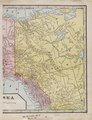
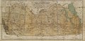
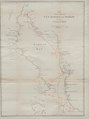
 Map of British Columbia drawn for the "Star" Almanac. (IA bp 1062).pdf 1,379 × 1,862; 1.08 MB
-
-
-
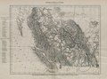
 A preliminary topographical map of a portion of the Foothills Region. (IA bp 123).pdf 2,541 × 3,337; 2.46 MB
-
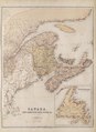
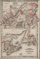
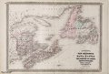
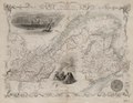
 Canada, New Brunswick and Nova Scotia. (IA bp 1234).pdf 3,160 × 2,339, 2 pages; 5.76 MB
-
-
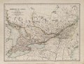
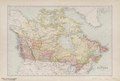
 Dominion of Canada (west-central portion) - (IA bp 126).pdf 3,554 × 5,072; 3.43 MB
-
 Dominion of Canada (Western sheet). (IA bp 1272).pdf 3,652 × 2,785; 3.76 MB
-
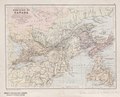
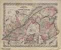 Canada East or Lower Canada and New Brunswick. (IA bp 1273).pdf 2,597 × 2,150, 2 pages; 4.14 MB
-
 Canada and Nova Scotia. (IA bp 1276).pdf 4,010 × 3,095; 3.18 MB
-
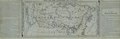
 Excise Inland Revenue map of Eastern Canada, 1884. (IA bp 1282).pdf 5,281 × 2,370; 5.21 MB
-
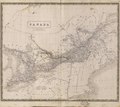 Canada (Upper and Lower). (IA bp 1319).pdf 3,525 × 3,152; 2.96 MB
-
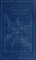
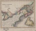 British Possessions (North America). (IA bp 1322).pdf 1,610 × 1,377; 1.2 MB
-
-
-
 Canada, New Brunswick, Nova Scotia etc., East sheet. (IA bp 1338).pdf 2,562 × 3,510; 2.19 MB
-
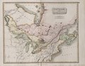
 Canada East formerly Lower Canada. (IA bp 1340).pdf 2,483 × 1,975; 2.28 MB
-
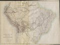 Brazil, Bolivia, Peru & Ecuador. (IA bp 13418).pdf 3,793 × 2,825; 3.62 MB
-
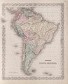 Coltons South America. (IA bp 13536).pdf 2,089 × 2,583, 2 pages; 3.85 MB
-
 British America. (IA bp 1388).pdf 1,668 × 1,310; 625 KB
-
 Dominion of Canada (Western sheet) (Ontario and Quebec). (IA bp 1393).pdf 2,772 × 2,131, 2 pages; 3.79 MB
-
-
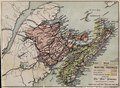
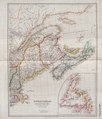
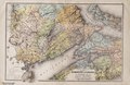
 Map of New Brunswick, Nova Scotia and Prince Edward Island (The Maritime Provinces of Canada). (IA bp 1447).pdf 1,947 × 2,470, 6 pages; 11.09 MB
-
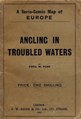 Angling in troubled waters- a serio-comic map of Europe. (IA bp 14539).pdf 743 × 1,095, 3 pages; 5.23 MB
-
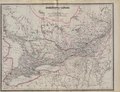
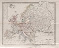
 Ethnographic map of Europe according to Dr. Gustaf Kombst. (IA bp 14636).pdf 3,750 × 3,102; 2.22 MB
-
 Europe. (IA bp 14660).pdf 2,579 × 2,110; 1.85 MB
-
 Map of the Maritime Provinces. (IA bp 1486).pdf 1,831 × 1,350; 942 KB
-
 Atlas des Campagnes et des Guerres sous Louis XV. (IA bp 14934).pdf 2,608 × 3,514, 4 pages; 12 MB
-
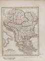
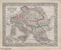
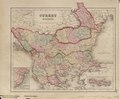
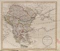 Turkey in Europe and Hungary. (IA bp 15082).pdf 2,947 × 2,472; 2.29 MB
-
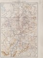
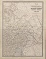
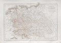
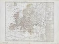
 (Map of Central Europe). (IA bp 15139).pdf 3,512 × 2,414; 3.7 MB
-
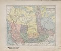
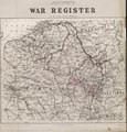 Johnston's War Register. (IA bp 15142).pdf 2,768 × 2,883; 3.33 MB
-
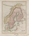 Sweden and Norway. (IA bp 15327).pdf 1,835 × 2,316; 1.44 MB
-
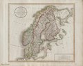
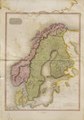 Scandinavia (from) Pinkerton's modern atlas. (IA bp 15328).pdf 3,345 × 4,783; 4.52 MB
-
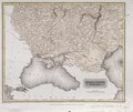
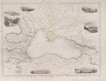 Black Sea. (IA bp 15365).pdf 2,018 × 1,543; 1.05 MB
-
-
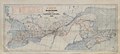
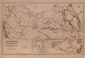
 Railway Map of Canada. (IA bp 1556).pdf 4,420 × 1,760; 1.42 MB
-
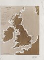
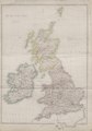 The British Isles. (IA bp 15579).pdf 2,766 × 3,962; 3.02 MB
-
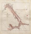
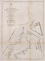
 Index map Royal Commission on Lights Buoys and Beacons. (IA bp 15619).pdf 2,110 × 2,860; 1.16 MB
-
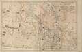
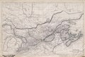
 Map of the Finlay and Omenica Rivers. (IA bp 16237).pdf 3,387 × 3,733; 2.73 MB
-
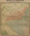 Ciudad de Maracaibo. (IA bp 18056).pdf 2,843 × 3,375; 2.75 MB
-
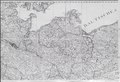
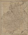
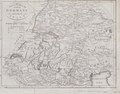
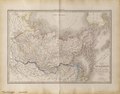
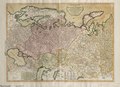
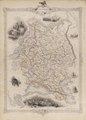
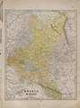
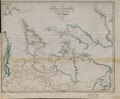
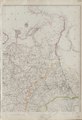 Russia in Europe. (IA bp 18666).pdf 1,922 × 2,806; 1.8 MB
-
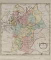
 Russia in Europe. (IA bp 19869).pdf 1,222 × 1,531; 668 KB
-
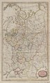
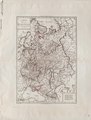
 Russia in Europe. (IA bp 19870).pdf 2,225 × 2,625; 1.52 MB
-
 Muscovy or Russia in Europe. (IA bp 19889).pdf 1,362 × 2,254; 1.12 MB
-
 Russia. (IA bp 19890).pdf 1,204 × 1,520; 784 KB
-
-
 Russland (States). (IA bp 19896).pdf 1,489 × 1,964, 12 pages; 8.01 MB
-
-
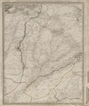
 Map of Turkistan comprising the countries between the Caspian and British India. (IA bp 19913).pdf 3,216 × 2,366, 2 pages; 4.76 MB
-
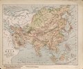
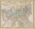 Asia, lithographed edition. (IA bp 20819).pdf 3,770 × 3,122; 4.83 MB
-
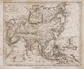 Asia, from the best authorities. (IA bp 20827).pdf 1,491 × 1,216; 784 KB
-
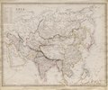 Asia. (IA bp 20994).pdf 2,381 × 1,979; 1.8 MB
-
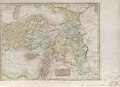 Turkey in Asia. (IA bp 21732).pdf 3,537 × 2,564; 2.68 MB
-
-
-
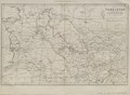
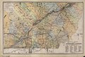
 General-Karte von Central Europa - General-Karte der osterreichisch-ungarischen Monarchie. (IA bp 24812).pdf 2,437 × 1,583, 25 pages; 66.92 MB
-
 (Ubersichtskarte von Mitteleuropa (Projektion nach Bonne)). (IA bp 24813).pdf 1,639 × 2,072, 11 pages; 32.19 MB
-
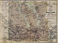 Map of Manitoba drawm (sic) for the "Star" Almanac. (IA bp 2697).pdf 1,283 × 943; 449 KB
-
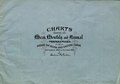
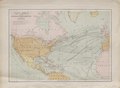
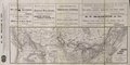
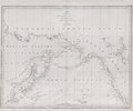 Chart of the Coasts of America & Asia from California to Macao. (IA bp 26979).pdf 2,966 × 2,479; 1.46 MB
-
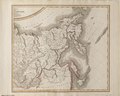
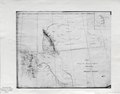 Sketch showing the route (in red) from Red River to the Pacific Ocean. (IA bp 2726).pdf 2,633 × 2,060; 751 KB
-
-
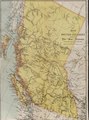
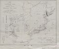
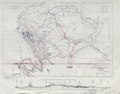
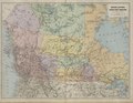
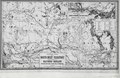
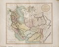
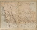 British Columbia, Vancouver Island, and the Valley of the Saskatchewan. (IA bp 2782).pdf 1,847 × 1,500; 920 KB
-
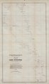 Map of Lake Winnipeg, to accompany Dr. Bell's Report for 1878. (IA bp 2806).pdf 3,035 × 5,250; 1.78 MB
-
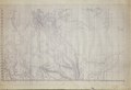 Map of the North-West Territory of the Province of Canada from actual survey during the years 1792 to 1812 . (IA bp 2820).pdf 22,568 × 15,335, 5 pages; 7.48 MB
-
-
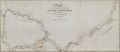
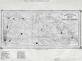
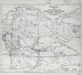
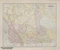
 British Columbia and the North West Territory in the Dominion of Canada. (IA bp 2875).pdf 4,141 × 3,202; 4.35 MB
-
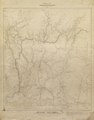
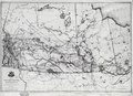
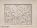
 Part of the North West Territories with projected township lines. (IA bp 2973).pdf 3,491 × 2,625; 2.4 MB
-
-
-
-
-
 Asie 1.000.000e. (IA bp 30361).pdf 3,354 × 2,312, 13 pages; 42.37 MB
-
-
-
 North West Territories. (IA bp 3134).pdf 2,964 × 1,968, 2 pages; 3.88 MB
-
-
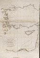
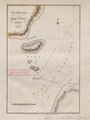 Entrance to Duke of York Bay, 1821. (IA bp 31977).pdf 1,139 × 1,514; 378 KB
-
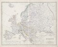
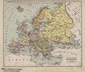
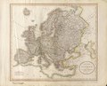
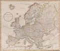 Europe drawn from the best authorities, by J. Russell. (IA bp 32019).pdf 2,729 × 2,329; 2.64 MB
-
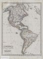
 North America. (IA bp 32086).pdf 1,931 × 3,108, 2 pages; 5.09 MB
-
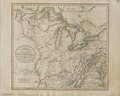
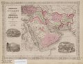 Johnson's Turkey in Asia, Persia, Arabia etc. (IA bp 32197).pdf 2,600 × 1,993, 2 pages; 3.37 MB
-
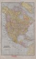
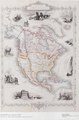
 America gezeichnet von F.v. Stulpnagel. (IA bp 32225).pdf 1,958 × 2,706; 1.54 MB
-
-
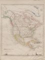
 North America. (IA bp 32240).pdf 1,887 × 2,875; 1.47 MB
-
 Gray's new map of Africa. (IA bp 32250).pdf 2,191 × 2,564, 2 pages; 3.38 MB
-
 North America. (IA bp 32254).pdf 1,302 × 1,743; 660 KB
-
 Austrian Dominions II- Galizia, eastern Hungary and Transylvania. (IA bp 32265).pdf 2,016 × 2,437; 2.08 MB
-
-
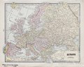
 Europe. (IA bp 32289).pdf 3,552 × 2,833; 3.36 MB
-
 Gray's new map of Europe. (IA bp 32307).pdf 2,364 × 2,052, 2 pages; 3.91 MB
-
 Europe. (IA bp 32334).pdf 3,085 × 2,114; 2.83 MB
-
-
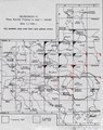
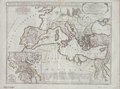
 Seat of war in the South of Germany & Nort of Italy. (IA bp 32370).pdf 1,695 × 1,329; 935 KB
-
-
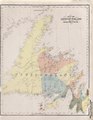 Map of Newfoundland from the geological map of Canada. (IA bp 32439).pdf 1,997 × 2,575, 2 pages; 4.18 MB
-
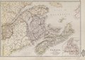
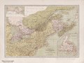
 Canada - New Brunswick & Nova Scotia. (IA bp 32474).pdf 2,691 × 1,806; 1.97 MB
-
 Upper & Lower Canada. (IA bp 32486).pdf 1,954 × 1,500; 838 KB
-
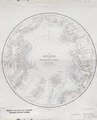
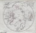 Chart of the Arctic Regions. (IA bp 32511).pdf 2,370 × 2,233; 1.68 MB
-
-
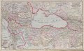
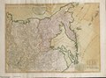
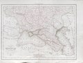 Carte de la Russie D'Europe, partie meridionale par Delamarche, 1836. (IA bp 32537).pdf 2,591 × 1,968; 1.46 MB
-
 Russia in Europe, Part V. (IA bp 32538).pdf 1,985 × 2,389; 2.23 MB
-
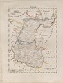
 South part of Russia in Europe. (IA bp 32545).pdf 2,477 × 1,602; 1.27 MB
-
 British North America. (IA bp 32554).pdf 1,783 × 1,420, 2 pages; 1.96 MB
-
 Russia in Europe- South part. (IA bp 32567).pdf 1,589 × 1,335; 852 KB
-
-
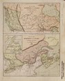
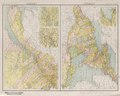
 Map of the Dominion of Canada - eastern part and Newfoundland and; western part. (IA bp 32601).pdf 1,464 × 1,839, 2 pages; 1.87 MB
-
-
 Map of the central part of the Province of Quebec, Canada, by Eugene Tache. (IA bp 32615).pdf 2,483 × 3,922, 2 pages; 6.74 MB
-
 Dominion of Canada & northern United States, by John Bartholomew. (IA bp 32618).pdf 2,733 × 2,043; 2.39 MB
-
 Map of the Dominion of Canada - Western section and Eastern section. (IA bp 32636).pdf 1,422 × 1,785, 2 pages; 1.67 MB
-
-
-
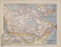
 Dominion of Canada, by J. Bartholomew. (IA bp 32658).pdf 3,139 × 2,125; 1.94 MB
-
-
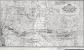
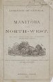
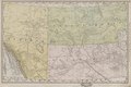
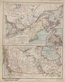
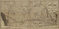
 Manitoba and the Northwest Territory, a map and five short chapters. Information for intending settlers. (IA bp 3267).pdf 3,387 × 1,093, 2 pages; 2.4 MB
-
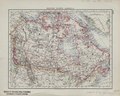
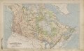 Physical map of the Dominion of Canada by J. Bartholomew. (IA bp 32687).pdf 2,883 × 1,750; 1.58 MB
-
 British America. (IA bp 32691).pdf 1,900 × 1,466, 2 pages; 1.99 MB
-
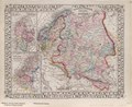
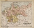 German Empire - Holland & Belgium. (IA bp 32698).pdf 1,741 × 1,422; 929 KB
-
 Quebec-Ontario. (IA bp 32703).pdf 2,606 × 2,079; 2.2 MB
-
 Dominion of Canada. (IA bp 32725).pdf 2,056 × 1,608; 1.45 MB
-
 Canada west including Manitoba, British Columbia etc. (IA bp 32730).pdf 2,060 × 1,725, 2 pages; 2.22 MB
-
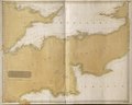 The British Channel. (IA bp 32761).pdf 3,908 × 3,133; 2.51 MB
-
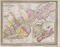
 Counties of Soulanges, Chambly ... Arthabaska, Montmagny, Quebec. (IA bp 32777).pdf 3,814 × 2,585, 2 pages; 8.03 MB
-
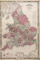 Johnson's England and Wales. (IA bp 32778).pdf 2,606 × 3,862, 2 pages; 7.75 MB
-
 Ontario & Quebec. (IA bp 32820).pdf 3,737 × 2,612; 3.81 MB
-
-
-
 British North America. (IA bp 32948).pdf 3,187 × 2,160; 2.17 MB
-
 Dominion of Canada (West Central sheet). (IA bp 32968).pdf 2,062 × 2,762; 1.85 MB
-
 Map of Europe. (IA bp 32984).pdf 2,516 × 2,052; 2.46 MB
-
 Europe. (IA bp 32989).pdf 2,125 × 1,702, 2 pages; 3.81 MB
-
 Europe. (IA bp 32990).pdf 2,585 × 2,058; 1.98 MB
-
 Hungary and Turkey in Europe. (IA bp 32994).pdf 1,420 × 1,893; 896 KB
-
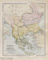
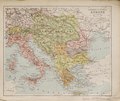
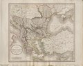
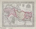
 The Turkish Empire in Europe and Asia with the Kingdom of Greece. (IA bp 32997).pdf 2,514 × 1,958; 1.64 MB
-
-
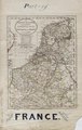
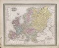
 Political map of Europe. (IA bp 33011).pdf 1,637 × 1,377; 979 KB
-
 Turkey in Europe - Greece, Roumania, Servia, Montenegro & Bulgaria. (IA bp 33012).pdf 1,460 × 1,831; 992 KB
-
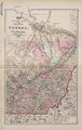
 Canada West formerly Upper Canada. (IA bp 33015).pdf 2,572 × 2,029; 1.65 MB
-
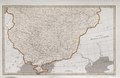
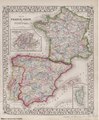 Map of France, Spain and Portugal. (IA bp 33017).pdf 1,839 × 2,225; 2 MB
-
 Europe. (IA bp 33019).pdf 1,997 × 1,600, 2 pages; 2.51 MB
-
 Map of the Austrian Empire, Italian States, Turkey in Europe, and Greece. (IA bp 33021).pdf 2,208 × 1,820; 1.91 MB
-
 Southern & Central Europe. (IA bp 33023).pdf 1,704 × 1,441; 998 KB
-
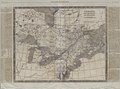
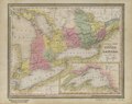
 Canada West and part of Canada East. (IA bp 33059).pdf 3,064 × 2,145; 2.34 MB
-
 Map of the eastern part of the Province of Quebec, Canada. (IA bp 33068).pdf 3,922 × 2,589, 2 pages; 4.72 MB
-
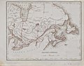
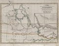
 (North western Canada). (IA bp 33088).pdf 1,643 × 2,145, 2 pages; 2.46 MB
-
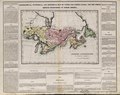
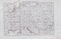
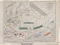
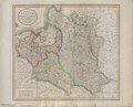
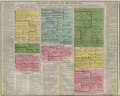
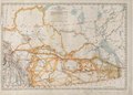
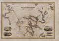
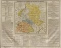 Geographical and statistical map of Poland and Hungary. (IA bp 33100).pdf 3,272 × 2,583, 2 pages; 5.98 MB
-
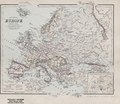
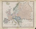
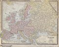
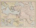
 Map of Europe by J. Pinkerton. (IA bp 33110).pdf 3,964 × 2,633; 5.51 MB
-
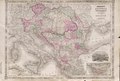 Johnson's Austria, Turkey in Europe and Greece. (IA bp 33111).pdf 3,954 × 2,658, 2 pages; 7.04 MB
-
-
-
-
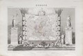
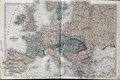
 A New map of Europe from the latest authorities, by John Carey, engraver. (IA bp 33122).pdf 3,762 × 3,027; 3.92 MB
-
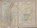
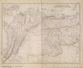 South American States. New Granada & Venezuela. (IA bp 33154).pdf 3,327 × 2,752; 2.81 MB
-
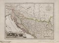 Provinces Illyriennes Servie et Bosnie. (IA bp 33177).pdf 2,116 × 1,531; 1.13 MB
-
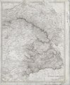
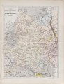 Carte physique et ethnographique de la Russie D'Europe par A. H. Dufour. (IA bp 33200).pdf 1,654 × 2,162; 1.29 MB
-
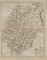
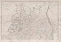 Russia in Europe. (IA bp 33205).pdf 3,154 × 2,204; 2.33 MB
-
-
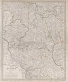
 Carte de la Russie D'Europe par J. B. Poirson ... 1802. (IA bp 33240).pdf 2,504 × 3,293; 2.32 MB
-
 Turkey in Europe. (IA bp 33253).pdf 2,495 × 2,064, 2 pages; 3.64 MB
-
-
-
 Russia in Europe. (IA bp 33280).pdf 1,529 × 2,131; 1.34 MB
-
-
 Russia in Europe. (IA bp 33282).pdf 1,495 × 2,010, 2 pages; 2.63 MB
-
-
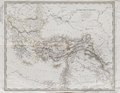
 Map of the Caucasus and portion of Turkey in Asia. (IA bp 33297).pdf 1,429 × 960; 454 KB
-
 Russia in Europe, Sweden and Norway. (IA bp 33309).pdf 2,254 × 1,843; 2.05 MB
-
-
-
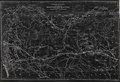
 Map of the Canadian Pacific Railway, and its connections. (IA bp 33347).pdf 3,752 × 1,875; 2.4 MB
-
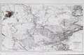
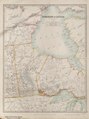
 Arctic discoveries & explorations up to July 1853. (IA bp 33395).pdf 3,825 × 3,231; 1.29 MB
-
-
-
-
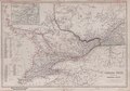
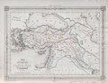
 Map of Persia, Turkey in Asia. Afghanistan, Beloochistan. (IA bp 33544).pdf 2,252 × 1,820; 1.73 MB
-
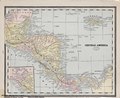 Central America. (IA bp 33563).pdf 1,968 × 1,614, 2 pages; 2.18 MB
-
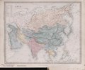
 Physical map of Asia. (IA bp 33570).pdf 1,747 × 1,460; 1.05 MB
-
 The Panjab with part of Afghanistan, Kashmeer, Sinde etc. (IA bp 33583).pdf 2,020 × 2,422; 1.81 MB
-
 Asia. (IA bp 33596).pdf 2,564 × 2,145; 1.92 MB
-
-
 Palestine - Ancient Jerusalem. (IA bp 33674).pdf 1,983 × 1,531, 2 pages; 2.05 MB
-
 Map of the countries mentioned in the Bible. (IA bp 33718).pdf 1,866 × 1,452; 984 KB
-
 Asie Ottomane ou Turquie D'Asie par V. Levasseur. (IA bp 33719).pdf 1,939 × 1,495; 944 KB
-
-
-
-
-
-
 Arctic regions with all the discoveries to 1853. (IA bp 3589).pdf 3,962 × 3,147; 3.68 MB
-
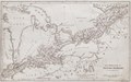 The Province of Upper Canada. (IA bp 3758).pdf 1,879 × 1,179; 748 KB
-
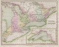 Upper Canada. From "Tanner's Universal Atlas". (IA bp 3759).pdf 2,310 × 1,843; 1.57 MB
-
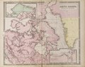
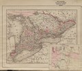
 Ontario of the Dominion of Canada. (IA bp 3798).pdf 3,864 × 2,627, 2 pages; 7.94 MB
-
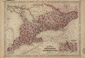
 Ontario in Counties. (IA bp 3799).pdf 2,108 × 1,837, 2 pages; 2.78 MB
-
-
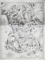
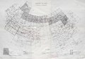
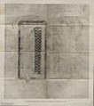
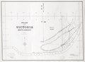 Plan of Victoria Settlement. (IA bp 3925).pdf 4,177 × 3,047; 1.32 MB
-
 The Arctic Expedition- Map of the Smith Sound route to the North Polar Sea. (IA bp 4007).pdf 1,556 × 2,254, 2 pages; 2.32 MB
-
-
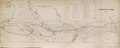
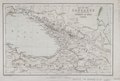
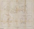
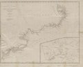
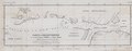 Carte des decouvertes du Capitaine Parry en 1819 et 1820. (IA bp 4038).pdf 3,737 × 1,452; 951 KB
-
-
-
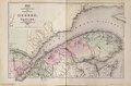
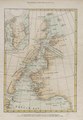
 East Canada, and New Brunswick. (IA bp 4095).pdf 2,089 × 1,612; 1.13 MB