Category:Wiegentobel
Jump to navigation
Jump to search
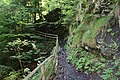
Deutsch: Das Wiegentobel ist ein unbewohntes, etwa 550 Meter langes Seitental des Frödischtals auf der Schattenseite des Frödischtals (nach Süden). Es beginnt in etwa 830 m.ü.A. und endet im Frödischtal auf etwa 621 m.ü.A (20,81° Gefälle bzw. 38%). Durch das Wiegentobel führt der Wiegentobelweg (Wanderweg), eine direkte Verbindung durch das Frödischtal von Dafins (Zwischenwasser) nach Viktorsberg.
English: The "Wiegentobel" is an approximately 550 Meter long side valley of the Froedischtal (valley) on the shadow side of the Froedischtal (to the south). It starts around 830 masl and ends in the Froedischtal at about 621 masl (20.81 ° gradient or 38%). The Wiegentobelweg (hiking path) leads through the Wiegentobel, a direct connection through the Froedischtal (valley) from Dafins (Zwischenwasser) to Viktorsberg.
Français : Le "Wieegntobel" est une vallée latérale d'environ 550 mètres de long de la Frödischtal (vallée) sur le côté ombragé de la Frödischtal (au sud). Il commence vers 830 mètres d'altitude et se termine dans le Frödischtal à environ 621 mètres d'altitude (gradient de 20,81 ° ou 38%). Le Wiegentobelweg (chemin de randonnée) mène à travers le Wiegentobel, une connexion directe à travers la Frödischtal (vallée) de Dafins (Zwischenwasser) à Viktorsberg.
uninhabited valley in the municipality of Zwischenwasser, Vorarlberg, Austria  | |||||
| Upload media | |||||
| Instance of | |||||
|---|---|---|---|---|---|
| Location | Zwischenwasser, Feldkirch District, Vorarlberg, Austria | ||||
| Elevation above sea level |
| ||||
 | |||||
Media in category "Wiegentobel"
The following 16 files are in this category, out of 16 total.
-
Dafins-Froedischtal-Froedisch-Wiegentobel-03ESD.ogv 31 s, 320 × 240; 7.87 MB
-
Dafins-Froedischtal-Froedisch-Wiegentobel-06ESD.ogv 24 s, 320 × 240; 6.01 MB
-
 Dafins-Froedischtal-Wiegentobel-01ASD.jpg 4,592 × 3,056; 9.38 MB
-
 Dafins-Wiegentobel-hiking path-01ASD.jpg 4,592 × 3,056; 6.75 MB
-
 Dafins-Wiegentobel-hiking path-02ASD.jpg 4,592 × 3,056; 7.81 MB
-
 Dafins-Wiegentobel-hiking path-03ASD.jpg 3,056 × 4,592; 2.73 MB
-
 Dafins-Wiegentobel-hiking path-06ASD.jpg 3,056 × 4,592; 2.73 MB
-
 Dafins-Wiegentobel-hiking path-06ESD.jpg 3,456 × 4,608; 3.1 MB
-
 Dafins-Wiegentobel-hiking path-07ESD.jpg 3,456 × 4,608; 2.68 MB
-
 Dafins-Wiegentobel-hiking path-08ASD.jpg 4,592 × 3,056; 8.63 MB
-
 Dafins-Wiegentobel-hiking path-09ASD.jpg 4,592 × 3,056; 8.94 MB
-
 Dafins-Wiegentobel-hiking path-bridge-01ASD.jpg 4,592 × 3,056; 7.56 MB
-
 Dafins-Wiegentobel-Masellahuette-01ASD.jpg 3,056 × 4,592; 1.92 MB
-
 Dafins-Wiegentobel-Masellahuette-02ASD.jpg 4,592 × 3,056; 7.44 MB
-
 Dafins-Wiegentobel-rivulet-01ASD.jpg 3,056 × 4,592; 2.42 MB
-
 Dafins-Wiegentobel-waterfall-01ASD.jpg 3,056 × 4,592; 2.26 MB


