Category:Utah State Route 290
Jump to navigation
Jump to search
 | number: | (two hundred ninety-) |
|---|---|---|
| State highways in Utah: | 270 · 271 · 273 · 274 · 275 · 276 · 279 · 280 · 281 · 282 · 284 · 285 · 286 · 287 · 288 · 289 · 290 · 291 · 292 · 293 · 294 · 295 · 296 · 297 · 298 · 299 · 300 · 301 · 302 · 303 · 304 · 305 · 306 · 307 · 308 · 309 · 310 |
state highway in Ephraim, Utah, United States | |||||
| Upload media | |||||
| Instance of | |||||
|---|---|---|---|---|---|
| Location | Ephraim, Sanpete County, Utah | ||||
| Transport network | |||||
| Owned by | |||||
| Maintained by | |||||
| Inception |
| ||||
| Length |
| ||||
| Terminus |
| ||||
 | |||||
English: Media related to Utah State Route 290, a 1.1960 miles (1.9248 km) state highway in eastern Ephraim, Utah, United States, that forms a three-quarter loop around Snow College (beginning and ending at Main Street [U.S. Route 89] and running along East Center Street, North 400 East, and East 100 North).
Subcategories
This category has the following 2 subcategories, out of 2 total.
S
Media in category "Utah State Route 290"
The following 3 files are in this category, out of 3 total.
-
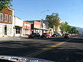 Ephraim utah 09-18-2010.jpg 2,816 × 2,112; 2.3 MB
-
 Utah 290.svg 750 × 600; 74 KB
-
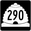 Utah SR 290.svg 385 × 385; 11 KB

