Category:Utah State Route 126
Jump to navigation
Jump to search
 | number: | (one hundred twenty-six) |
|---|---|---|
| State highways in Utah: | 106 · 107 · 108 · 109 · 110 · 111 · 112 · 113 · 114 · 115 · 116 · 117 · 118 · 119 · 120 · 121 · 122 · 123 · 124 · 125 · 126 · 127 · 128 · 129 · 130 · 131 · 132 · 133 · 134 · 135 · 136 · 137 · 138 · 139 · 140 · 141 · 142 · 143 · 144 · 145 · 146 |
state highway in Davis, Weber, and Box Elder counties in Utah, United States   | |||||
| Upload media | |||||
| Instance of | |||||
|---|---|---|---|---|---|
| Location |
| ||||
| Transport network | |||||
| Connects with | |||||
| Owned by | |||||
| Maintained by | |||||
| Inception |
| ||||
| Length |
| ||||
| Terminus | |||||
| Replaces | |||||
| |||||
English: Media related to Utah State Route 126, a 21.586-mile (34.739 km) state highway Davis, Weber, and Box Elder counties in northern Utah, United States, that runs mostly west of and roughly parallel to Interstate 15 (I‑15) and connects Fort Lane in Layton (in northern Davis County) with U.S. Route 89 in South Willard (on the southeastern edge of Box Elder County), with an interchange with I‑15 near both ends of the route. (The southern have of the route runs along the former routing of U.S. 91 [prior to 1974].)
Subcategories
This category has the following 3 subcategories, out of 3 total.
S
Media in category "Utah State Route 126"
The following 10 files are in this category, out of 10 total.
-
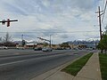 East at SR-108 & SR-126 junction in Layton, Utah, May 17.jpg 2,592 × 1,944; 2.36 MB
-
 North at SR-108 & SR-126 junction in Layton, Utah, May 17.jpg 2,592 × 1,944; 2.33 MB
-
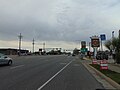
 Northwest along SR-126 in Layton, Utah, Jan 16.jpg 2,816 × 2,112; 2.48 MB
-
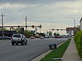
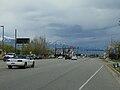 South at SR-108 & SR-126 junction in Layton, Utah, May 17.jpg 2,592 × 1,944; 2.36 MB
-
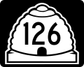
 SR-126 shield in Layton, Utah, May 17.jpg 1,944 × 2,592; 1.62 MB
-
 Utah 126.svg 750 × 600; 73 KB
-
 Utah Route 103 map.png 1,138 × 852; 35 KB
-
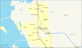 Utah SR 126 map.svg 1,475 × 860; 431 KB
-
 Utah SR 126.svg 385 × 385; 9 KB
-
 West at SR-108 & SR-126 junction in Layton, Utah, May 17.jpg 2,592 × 1,944; 2.36 MB


