Category:United Kingdom photographs taken on 2004-08-14
Jump to navigation
Jump to search
Countries of Europe: Belarus · Belgium · Croatia · Denmark · France‡ · Germany · Hungary · Italy · Malta · Monaco · Netherlands‡ · Poland · Russia‡ · Serbia · Spain‡ · Sweden · Switzerland · Ukraine · United Kingdom
‡: partly located in Europe
‡: partly located in Europe
| ← | 14 August 2004 | → | ||
| ← | August 2004 | → | ||

United Kingdom photographs taken on 14 August 2004.
Image files should be categorized here automatically using {{taken on}} template. Direct categorisation is also possible, if automatic is impossible.
Media in category "United Kingdom photographs taken on 2004-08-14"
The following 87 files are in this category, out of 87 total.
-
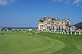 18th Green and Clubhouse.jpg 640 × 427; 65 KB
-
 A'Chioch - geograph.org.uk - 9444.jpg 640 × 457; 85 KB
-
 Aira Force (Ullswater) - geograph.org.uk - 176899.jpg 640 × 480; 146 KB
-
 Alnwick Castle - geograph.org.uk - 63990.jpg 640 × 433; 75 KB
-
 Alnwick Tenants' Column - geograph.org.uk - 63982.jpg 480 × 640; 117 KB
-
 Alton Water Reservoir - geograph.org.uk - 13965.jpg 640 × 480; 106 KB
-
 AmyandJim fishing boat, Aldeburgh Beach - geograph.org.uk - 226020.jpg 640 × 503; 244 KB
-
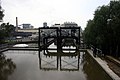 Anderton Boat Lift - geograph.org.uk - 1592.jpg 640 × 427; 57 KB
-
 Arbroath Harbour.jpg 640 × 480; 166 KB
-
 Beachy Head, Eastbourne Coast - geograph.org.uk - 737.jpg 480 × 640; 46 KB
-
 Bealach na Ba - geograph.org.uk - 9434.jpg 640 × 451; 55 KB
-
 Bealach na Ba - geograph.org.uk - 9449.jpg 640 × 480; 78 KB
-
 Bealach na Ba road - geograph.org.uk - 9435.jpg 640 × 371; 56 KB
-

-
 Brown Low, Ludworth Intakes - geograph.org.uk - 44761.jpg 640 × 480; 157 KB
-
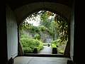 Buckland Abbey, The Herb Garden - geograph.org.uk - 210993.jpg 640 × 480; 88 KB
-
 Burn - geograph.org.uk - 431848.jpg 640 × 480; 131 KB
-

-

-
 Cairn, Ludworth Intakes - geograph.org.uk - 44760.jpg 640 × 480; 116 KB
-
 Carrow Road Football ground - geograph.org.uk - 23005.jpg 640 × 480; 114 KB
-
 Clachnaben Path - geograph.org.uk - 56746.jpg 640 × 475; 78 KB
-
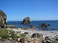 Cladach Dhìobadail - geograph.org.uk - 3089.jpg 640 × 480; 47 KB
-
 Cliffs near Kame of Hoy - geograph.org.uk - 87755.jpg 640 × 480; 70 KB
-
 Clifton Wood Bristol - geograph.org.uk - 6218.jpg 640 × 480; 129 KB
-
 Coastal scenery east of Cobha Sgeir - geograph.org.uk - 1250928.jpg 640 × 480; 70 KB
-
 Cottage at New Moat - geograph.org.uk - 20436.jpg 640 × 480; 198 KB
-
 Donmouth Beach, Aberdeen - geograph.org.uk - 105814.jpg 640 × 480; 36 KB
-
 Dovedale, Dalby Forest - geograph.org.uk - 1601545.jpg 480 × 640; 95 KB
-
 Drake's Island - geograph.org.uk - 54989.jpg 640 × 480; 49 KB
-
 Eilean nan Gamhna - geograph.org.uk - 200603.jpg 600 × 308; 51 KB
-
 North Bank Towers - geograph.org.uk - 6952.jpg 640 × 480; 54 KB
-
 Forestry access road near Worlds End - geograph.org.uk - 47509.jpg 640 × 480; 116 KB
-
 Golitha Falls - geograph.org.uk - 93009.jpg 640 × 480; 188 KB
-
 Haytor - geograph.org.uk - 210962.jpg 640 × 480; 89 KB
-
 Hollywood End - geograph.org.uk - 44765.jpg 480 × 640; 85 KB
-
 Larne lifeboat at Cushendall - geograph.org.uk - 641005.jpg 640 × 418; 75 KB
-
 Loch an Dùin - geograph.org.uk - 1250890.jpg 640 × 480; 87 KB
-
 Lochan on Sgurr na Chaorachain - geograph.org.uk - 9446.jpg 640 × 411; 98 KB
-
 Lowther Castle 02.jpg 640 × 442; 131 KB
-
 Lucky Spot - geograph.org.uk - 1153459.jpg 640 × 480; 80 KB
-
 Madras RFC Playing Fields St Andrews - geograph.org.uk - 17125.jpg 640 × 427; 78 KB
-
 Marina at Rawcliffe Bridge.jpg 640 × 480; 149 KB
-
 Nant y Coed - geograph.org.uk - 649596.jpg 640 × 480; 129 KB
-
 Rhos Fawr - geograph.org.uk - 490422.jpg 640 × 480; 83 KB
-
 Richmond- Market Square.jpg 1,024 × 768; 233 KB
-
 Sandstone on Beinn Bhan - geograph.org.uk - 9442.jpg 640 × 405; 81 KB
-
 St Peter's Church, Selsey - geograph.org.uk - 361566.jpg 640 × 480; 112 KB
-
 Shanklin village - geograph.org.uk - 498882.jpg 640 × 480; 156 KB
-
 ShapAbbey(SimonLedingham)Aug2004.jpg 640 × 480; 135 KB
-
 St Anthony Lighthouse.jpg 640 × 482; 72 KB
-
 Summit of Beinn Bhan - geograph.org.uk - 9443.jpg 640 × 432; 79 KB
-
 Summit of Carnedd y Filiast - geograph.org.uk - 649583.jpg 640 × 480; 60 KB
-

-
 The Great Orme - geograph.org.uk - 9055.jpg 640 × 480; 112 KB
-
 The Great Orme - geograph.org.uk - 9057.jpg 640 × 480; 115 KB
-
 The Trent and Mersey Canal at Stone - geograph.org.uk - 111363.jpg 640 × 560; 103 KB
-
 Traffic Crossing the Bridge of Don - geograph.org.uk - 94148.jpg 640 × 480; 58 KB
-
 Trig Point on Axe Edge, 1810' - geograph.org.uk - 1103858.jpg 640 × 427; 46 KB
-
 Tràigh Chrois - geograph.org.uk - 1250996.jpg 640 × 480; 62 KB
-
-

-
 Widecombe in the Moor from On High - geograph.org.uk - 210965.jpg 640 × 480; 121 KB
-

-
 Carradale Harbour. - geograph.org.uk - 76190.jpg 640 × 480; 121 KB
-
 Charr Bothy - Glen Dye - geograph.org.uk - 91436.jpg 640 × 480; 68 KB
-
 Coire nan Cuileag - geograph.org.uk - 9436.jpg 640 × 427; 79 KB
-
 Forestry road - geograph.org.uk - 649605.jpg 640 × 480; 127 KB
-
 Gil Dhìobadail - geograph.org.uk - 3094.jpg 640 × 480; 72 KB
-

-
 Head of Loch Kishorn, Tornapress. - geograph.org.uk - 9432.jpg 640 × 457; 83 KB
-

-
 Morris's Bridge - geograph.org.uk - 413725.jpg 480 × 640; 147 KB
-
 Mount Shade - geograph.org.uk - 57641.jpg 640 × 475; 42 KB
-
 Near Holmsley, New Forest - geograph.org.uk - 42674.jpg 640 × 427; 74 KB
-
 Old Military Road - geograph.org.uk - 31155.jpg 640 × 480; 134 KB
-
 Rheged - 'The Village in The Hill' - geograph.org.uk - 75787.jpg 640 × 502; 199 KB
-
 Sgurr a Chaorachain - geograph.org.uk - 9448.jpg 640 × 431; 68 KB
-

-
 Slatrach Bay - geograph.org.uk - 200607.jpg 600 × 373; 87 KB
-
 Stalkers path, Coire Cuileag - geograph.org.uk - 9437.jpg 640 × 508; 113 KB
-
 Summit of Carn Dearg. - geograph.org.uk - 9445.jpg 640 × 409; 83 KB
-
 The Applecross Escarpment - geograph.org.uk - 9440.jpg 640 × 414; 63 KB
-
 Tree harvesting at Llwyd - geograph.org.uk - 47507.jpg 640 × 480; 154 KB
-
 Tràigh Ghearadha - geograph.org.uk - 3007.jpg 640 × 480; 41 KB
-

-


_-_geograph.org.uk_-_176899.jpg)


Aug2004.jpg)


