Category:Turgot map of Paris, Kyoto University Library
Jump to navigation
Jump to search
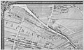
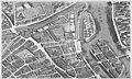
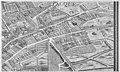
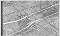
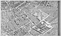
English: The Turgot map of Paris was published in 1739 as an atlas of 20 sectional bird's eye-view maps and one simplified general map with a 4 x 5 grid showing the layout of the 20 sectional maps. Each map is about 30.5 x 19.2 inches (77.5 x 49 cm) and consists of double facing sheets. If the sectional maps were laid out as a single large map of Paris, it would measure 122 x 96 inches (3.1 x 2.4 meters). The perspective view of the map is toward the southeast. Digital versions (at various resolutions and in JPEG format) of a copy of Turgot's atlas at the Kyoto University Library were published in the year 2000 on the library's website (see [1]). The library website divided the highest resolution (150-DPI) images of each map into separate, slightly overlapping detailed views (for example, see plate 1). The images shown here have been reassembled from the detailed views into complete sectional maps corresponding to the original plates of the atlas. (To see the thumbnails in a 4 x 5 array, adjust the width of your browser window.)
Subcategories
This category has only the following subcategory.
Media in category "Turgot map of Paris, Kyoto University Library"
The following 22 files are in this category, out of 22 total.
-
 Turgot map Paris KU 01.jpg 4,800 × 2,900; 4.14 MB
-
 Turgot map Paris KU 02.jpg 4,800 × 2,900; 3.9 MB
-
 Turgot map Paris KU 03.jpg 4,800 × 2,900; 4.43 MB
-
 Turgot map Paris KU 04.jpg 4,800 × 2,900; 4.56 MB
-
 Turgot map Paris KU 05.jpg 4,800 × 2,900; 4.24 MB
-
 Turgot map Paris KU 06.jpg 4,800 × 2,900; 4.22 MB
-
 Turgot map Paris KU 07.jpg 4,800 × 2,900; 4.34 MB
-
 Turgot map Paris KU 08.jpg 4,800 × 2,900; 4.49 MB
-
 Turgot map Paris KU 09.jpg 4,800 × 2,900; 5 MB
-
 Turgot map Paris KU 10.jpg 4,800 × 2,900; 4.24 MB
-
 Turgot map Paris KU 11.jpg 4,800 × 2,900; 4.4 MB
-
 Turgot map Paris KU 12.jpg 4,800 × 2,900; 4.24 MB
-
 Turgot map Paris KU 13.jpg 4,800 × 2,900; 4.44 MB
-
 Turgot map Paris KU 14.jpg 4,800 × 2,900; 4.27 MB
-
 Turgot map Paris KU 15.jpg 4,800 × 2,900; 4.53 MB
-
 Turgot map Paris KU 16.jpg 4,800 × 2,900; 4.24 MB
-
 Turgot map Paris KU 17.jpg 4,800 × 2,900; 4.26 MB
-
 Turgot map Paris KU 18.jpg 4,800 × 2,900; 4.26 MB
-
 Turgot map Paris KU 19.jpg 4,800 × 2,900; 4.3 MB
-
 Turgot map Paris KU 20.jpg 4,800 × 2,900; 4.29 MB
-
 Turgot map of Paris, Kyoto University Library.jpg 19,080 × 14,490; 211.37 MB
-
 Turgot map Paris KU general map.jpg 4,016 × 2,995; 5.41 MB


