Category:Tsunamis in Japan
Jump to navigation
Jump to search
Countries of Asia: East Timor · India · Indonesia‡ · Japan · Malaysia · Maldives · Philippines · Sri Lanka · Thailand
Limited recognition: Taiwan
‡: partly located in Asia
Limited recognition: Taiwan
‡: partly located in Asia
Wikimedia category | |||||
| Upload media | |||||
| Instance of | |||||
|---|---|---|---|---|---|
| Category combines topics | |||||
 | |||||
Subcategories
This category has the following 14 subcategories, out of 14 total.
Media in category "Tsunamis in Japan"
The following 53 files are in this category, out of 53 total.
-

-

-
-
-

-

-
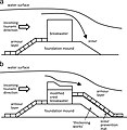
 Countermeasures against level 1 and level 2 tsunamis.jpg 1,740 × 625; 115 KB
-
 Damage to Yamamoto sea dikes observed during the 2011 EEFIT mission.jpg 1,900 × 1,541; 596 KB
-
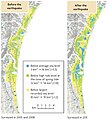
 Dikes in Sendai before and after the tsunami of March 11 2011.jpg 2,277 × 1,414; 318 KB
-
 East Sendai Expressway.jpg 1,718 × 2,822; 702 KB
-
-
 Evacuation stairway at the Omoto Elementary School.jpg 894 × 671; 112 KB
-

-
 Example of new coastal embankment and breakwater.jpg 1,441 × 1,136; 242 KB
-

-
 Forecasted fault segments on the plate interface near the Tohoku region.jpg 1,488 × 1,844; 282 KB
-
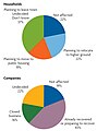
 Gap between people moving in and people moving out as a share of the population.jpg 1,559 × 1,929; 232 KB
-
 Genroku earthquake of return assumed tsunami height Tateyama Chiba.JPG 2,272 × 1,704; 847 KB
-
-
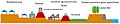 Image of the multilayer tsunami countermeasure.jpg 2,445 × 481; 103 KB
-
 JMA Tsunami Warnings 1 January 2024 ja.png 878 × 988; 257 KB
-
 Mat foundation of Building A and pile foundation of Building D.jpg 827 × 303; 178 KB
-
 Memories (8544037991).jpg 3,434 × 2,289; 1.41 MB
-
 Okumatsushima tsunami P1130116.JPG 4,000 × 3,000; 6.73 MB
-
 Okumatsushima tsunami P1130317 rotated.jpg 3,000 × 4,000; 5.75 MB
-
 Pile foundation of Building C - one pile pulled out of ground.jpg 1,192 × 309; 306 KB
-
 Pile foundation of Buildings B and E.jpg 965 × 481; 309 KB
-
-
 Print depicting a 19th-century tsunami hitting Miyagi Prefecture (13720268494).jpg 2,500 × 1,864; 1.97 MB
-

-

-

-
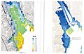
 Recovery concept of Minamisanriku Town.jpg 1,311 × 1,127; 143 KB
-
 Rehabilitating a whale specimen.jpg 892 × 728; 117 KB
-

-
 Sanriku-Erdbeben.jpg 796 × 858; 161 KB
-
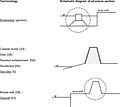 Sea defence structure terminology.jpg 2,501 × 2,232; 297 KB
-
 Seawall damage observed during the 2011 EEFIT Mission.jpg 1,900 × 1,539; 616 KB
-

-
 Sendai Airport after the tsunami.jpg 1,297 × 896; 199 KB
-
 Sign of Route for Tsunami Evacuation Building in Japan.jpg 3,216 × 4,288; 4.67 MB
-

-
 Structure of a highly resilient breakwater.jpg 1,726 × 686; 278 KB
-
 Subsidence caused by the earthquake increased inundation risks.jpg 1,301 × 1,416; 328 KB
-
-
-
 Tsunami escape route to Zuiganji in Japan.jpg 4,000 × 3,000; 3.56 MB
-
 Tsunami protection under renewal.jpg 3,264 × 2,448; 1.55 MB
-
 Tsunami simulations Ofunato City.jpg 1,266 × 815; 152 KB
-
 Tsunami wall.jpg 768 × 1,024; 134 KB
-
 Tsunami Warning Flag in Japan Vector.svg 512 × 512; 2 KB
-
 Tsunami Warning Flag in Japan.png 300 × 250; 10 KB
-
 津波伝播の様子(2003年十勝沖地震).png 1,050 × 742; 424 KB
,_which_survived_-29-9-2011-,_and_building_B,_which_was_overturned_-29-3-2011-.jpg)


.jpg)


.jpg)
.jpg)
_(cropped).jpg)
.jpg)


,_and_a_detailed_picture_of_a_pile_foundation_from_building_B_-3-9-2011-.jpg)