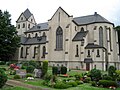
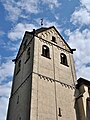
Category:St. Matthias (Krefeld-Hohenbudberg)
Jump to navigation
Jump to search
| Object location | | View all coordinates using: OpenStreetMap |
|---|
parish church   | |||||
| Upload media | |||||
| Instance of | |||||
|---|---|---|---|---|---|
| Location | Hohenbudberg, Krefeld, Düsseldorf Government Region, North Rhine-Westphalia, Germany | ||||
| Diocese | |||||
| Heritage designation | |||||
 | |||||
This is the category for an architectural monument.
It is on the list of cultural monuments of Krefeld, no. 59.
It is on the list of cultural monuments of Krefeld, no. 59.
Subcategories
This category has only the following subcategory.
Media in category "St. Matthias (Krefeld-Hohenbudberg)"
The following 14 files are in this category, out of 14 total.
-
 Hohenbudberg St. Matthias.jpg 6,000 × 4,000; 6.48 MB
-
 Hohenbudberg2.jpg 1,024 × 768; 342 KB
-
 Krefeld, Hohenbudberg, Dorfstraße 2, 2020-04 CN-03.jpg 3,869 × 2,347; 6.89 MB
-
 Krefeld, St. Matthias, 2011-08 CN-01.jpg 4,417 × 3,182; 10.3 MB
-
 Krefeld, St. Matthias, 2011-08 CN-02.jpg 1,449 × 2,547; 2.38 MB
-
 Krefeld, St. Matthias, 2011-08 CN-04.jpg 4,184 × 2,466; 12.26 MB
-
 Krefeld, St. Matthias, 2011-08 CN-05.jpg 3,510 × 2,470; 6.49 MB
-
 Krefeld, St. Matthias, 2011-08 CN-07.jpg 3,586 × 2,521; 6.81 MB
-
 Krefeld, St. Matthias, 2011-08 CN-08.jpg 2,592 × 3,872; 6.07 MB
-
 Krefeld, St. Matthias, 2011-08 CN-09.jpg 2,592 × 3,456; 5.38 MB
-
 Krefeld, St. Matthias, 2020-04 CN-01.jpg 4,501 × 3,119; 13.99 MB
-
 Krefeld, St. Matthias, 2020-04 CN-02.jpg 3,080 × 4,182; 11.8 MB
-
 St. Matthias (Krefeld-Hohenbudberg)1.JPG 1,542 × 1,529; 665 KB
-
 St. Matthias (Krefeld-Hohenbudberg)2.JPG 1,783 × 1,154; 625 KB


1.JPG)
2.JPG)
Categories:
- Roman Catholic churches in Krefeld
- Saint Matthias churches in North Rhine-Westphalia
- Gothic Revival churches in Kreis Wesel
- Churches in North Rhine-Westphalia built in 1854
- Buildings by Vincenz Statz
- Cultural heritage monuments in Uerdingen
- Vincenz Statz
- Hohenbudberg
- Architectural basilicas in Regierungsbezirk Düsseldorf
- Gothic Revival churches in Regierungsbezirk Düsseldorf
- 1850s churches in Regierungsbezirk Düsseldorf