Category:Smith's Bridge (Delaware)
Jump to navigation
Jump to search
| Object location | | View all coordinates using: OpenStreetMap |
|---|
covered bridge in New Castle County, Delaware, USA  | |||||
| Upload media | |||||
| Instance of | |||||
|---|---|---|---|---|---|
| Location | New Castle County, Delaware | ||||
| Inception |
| ||||
| Significant event |
| ||||
 | |||||
Media in category "Smith's Bridge (Delaware)"
The following 14 files are in this category, out of 14 total.
-

-

-

-

-
-

-

-

-
-

-

-
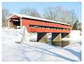
 Smith's Bridge-November 2015.JPG 552 × 374; 47 KB
-
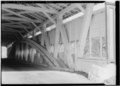
 SMITH'S COVERED BRIDGE, NEW CASTLE COUNTY, DELAWARE.jpg 3,000 × 1,991; 475 KB
-
 Smithbridge.jpeg 1,074 × 818; 134 KB
.png)
.png)
.png)
.png)

