Category:Siegerlandhütte
Jump to navigation
Jump to search
| Object location | | View all coordinates using: OpenStreetMap |
|---|

 | |||||
| Upload media | |||||
| Instance of |
| ||||
|---|---|---|---|---|---|
| Location | Sölden, Imst District, Tyrol, Austria | ||||
| Owned by | |||||
| Mountain range | |||||
| Elevation above sea level |
| ||||
| official website | |||||
 | |||||
![]() Austria
Austria ![]() Land Tirol - 2.710 m ü. A.
Land Tirol - 2.710 m ü. A.
Media in category "Siegerlandhütte"
The following 5 files are in this category, out of 5 total.
-
 Siegerlandhütte 2010.jpg 3,264 × 2,448; 3.68 MB
-
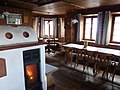 Siegerlandhütte Gastraum.jpg 3,264 × 2,448; 3.49 MB
-
 Siegerlandhütte vom Aufstiegsweg.jpg 3,264 × 2,448; 3.65 MB
-
 Siegerlandhütte.jpg 4,224 × 2,376; 836 KB
-
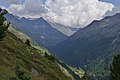 Windach-O.jpg 6,000 × 4,000; 5.77 MB


