Category:Seltún
Jump to navigation
Jump to search
Geothermal Area located in the sulphur area Krýsuvík in Iceland .jpg) | |||||
| Upload media | |||||
| Instance of | |||||
|---|---|---|---|---|---|
| Location | Hafnarfjörður, Hafnarfjarðarkaupstaður, Capital Region, Iceland | ||||
 | |||||
Deutsch: Seltún ist ein Hochtemperaturgebiet im Südwesten von Island, ca 3 km nördlich der Kirche von Krýsuvík und ca 1 km nördlich vom Hof Krýsuvík und gehört zum gleichnamigen Vulkansystem. In der Landnáma wird erwaähnt, dass der Landnahmemann Þórir haustmyrkur sich dort niederließ.
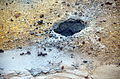
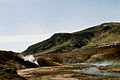
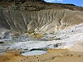
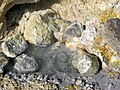
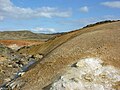
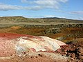
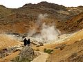
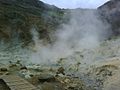
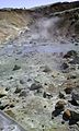
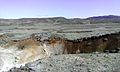
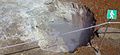
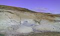
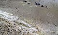
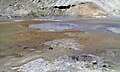
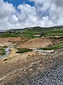
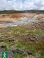
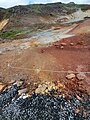
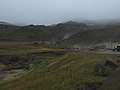
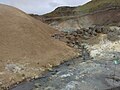
English: The geothermal area of sulphur fields and hot springs Seltún in the wilderness Krýsuvík Iceland, part of the Krýsuvík volcanic system.
Subcategories
This category has the following 17 subcategories, out of 17 total.
+
.
- Hiking trails at Seltún (5 F)
- Viewpoints at Seltún (6 F)
A
- Acidic lakes in Seltún (10 F)
B
- Boulders at Seltún (8 F)
D
F
- Fumaroles at Seltún (2 F)
H
M
P
- Parking lot at Seltún (5 F)
S
- Stóra-Lambafell (Krýsuvík) (10 F)
- Sulfur deposits at Seltún (3 F)
V
Media in category "Seltún"
The following 168 files are in this category, out of 168 total.
-
 2014-09-13 18-37-33 Iceland - Hafnarfirði Vogar 3h 176°.JPG 10,042 × 2,493; 21.12 MB
-
 A brief stop to see the streaming puddles and bubbling mud pots. (3022605623).jpg 1,800 × 1,350; 648 KB
-
 Capital Region, Iceland - panoramio (14).jpg 5,616 × 3,744; 4.14 MB
-
 Capital Region, Iceland - panoramio (15).jpg 5,616 × 3,744; 3.1 MB
-
 Capital Region, Iceland - panoramio (19).jpg 5,616 × 3,744; 2.84 MB
-
 Capital Region, Iceland - panoramio (20).jpg 5,616 × 3,744; 2.79 MB
-
 IJsland hete bronnen.jpg 3,008 × 2,000; 5.26 MB
-
 IS-seltun-bach.jpg 4,928 × 3,264; 5.28 MB
-
 IS-seltun-loch.jpg 4,928 × 3,264; 5.37 MB
-
 IS-seltun-schlammloch-1.jpg 4,928 × 3,264; 7.32 MB
-
 Krisuvik.jpg 1,536 × 1,024; 341 KB
-
 Krysuvik Iceland 001.JPG 1,200 × 900; 170 KB
-
 Krysuvik Iceland 004.JPG 1,200 × 900; 292 KB
-
 Krysuvik Iceland 005.JPG 1,200 × 900; 187 KB
-
 Krysuvik Iceland 006.JPG 1,200 × 900; 338 KB
-
 Krysuvik Iceland 008.JPG 1,200 × 900; 233 KB
-
 Krysuvik Iceland 012.JPG 1,200 × 900; 199 KB
-
 Krysuvik Iceland 013.JPG 1,200 × 900; 290 KB
-
 Krysuvik Iceland 020.JPG 1,200 × 900; 297 KB
-
 Krysuvik Iceland 022.JPG 1,200 × 900; 192 KB
-
 Krysuvik Iceland 023.JPG 1,200 × 900; 272 KB
-
 Krysuvik Iceland 024.JPG 1,200 × 900; 385 KB
-
 Krysuvik Iceland 026.JPG 1,200 × 900; 278 KB
-
 Krysuvik Iceland 027.JPG 1,200 × 900; 167 KB
-
 Krysuvik Iceland 028.JPG 1,200 × 900; 288 KB
-
 Krysuvik Iceland 029.JPG 1,200 × 900; 201 KB
-
 Krysuvik Iceland 031.JPG 1,200 × 900; 194 KB
-
 Krysuvik Iceland 032.JPG 1,200 × 900; 191 KB
-
 Krysuvik Iceland 033.JPG 1,200 × 900; 204 KB
-
 Krysuvik Iceland 037.JPG 1,200 × 900; 257 KB
-
 Krysuvik Iceland 041.JPG 1,200 × 900; 223 KB
-
 Krysuvik Iceland 042.JPG 1,200 × 900; 343 KB
-
 KrysuvikSeltun3.JPG 3,072 × 2,304; 1.95 MB
-
 KrysuvikWinter.jpg 2,979 × 1,979; 931 KB
-
 Krísuvík - panoramio (1).jpg 1,600 × 1,200; 464 KB
-
 Krísuvík - panoramio.jpg 1,600 × 1,200; 436 KB
-
 Krýsuvík May 2017--203.jpg 2,200 × 1,320; 805 KB
-
 Krýsuvík May 2017--207.jpg 1,320 × 2,200; 933 KB
-
 Krýsuvík May 2017--208.jpg 2,200 × 1,320; 1,005 KB
-
 Krýsuvík May 2017--209.jpg 2,200 × 1,320; 1.07 MB
-
 Krýsuvík May 2017--215.jpg 1,320 × 2,200; 931 KB
-
 Krýsuvík May 2017--216.jpg 2,200 × 1,320; 807 KB
-
 Krýsuvík May 2017--217.jpg 2,200 × 1,320; 959 KB
-
 Krýsuvík May 2017--218.jpg 2,200 × 1,320; 768 KB
-
 Krýsuvík May 2017--219.jpg 2,200 × 1,320; 926 KB
-
 Krýsuvík May 2017--220.jpg 2,200 × 1,320; 1,012 KB
-
 Krýsuvík May 2017--221.jpg 2,200 × 1,320; 908 KB
-
 Krýsuvík May 2017--222.jpg 2,200 × 1,320; 786 KB
-
 Krýsuvík May 2017--223.jpg 1,760 × 807; 185 KB
-
 Krýsuvík May 2017--224.jpg 2,200 × 1,320; 595 KB
-
 Krýsuvík May 2017--225.jpg 2,200 × 1,320; 556 KB
-
 Krýsuvík May 2017-105.jpg 2,200 × 1,320; 735 KB
-
 Krýsuvík May 2017-107.jpg 2,200 × 1,320; 1.04 MB
-
 Krýsuvík May 2017-108.jpg 1,484 × 593; 157 KB
-
 Krýsuvík May 2017-109.jpg 2,200 × 1,320; 883 KB
-
 Krýsuvík May 2017-111.jpg 2,200 × 1,320; 926 KB
-
 Krýsuvík May 2017-113.jpg 2,200 × 1,320; 717 KB
-
 Krýsuvík May 2017-115.jpg 2,200 × 1,320; 860 KB
-
 Krýsuvík May 2017-117.jpg 2,200 × 1,320; 811 KB
-
 Krýsuvík May 2017-118.jpg 2,200 × 1,320; 781 KB
-
 Krýsuvík May 2017-119.jpg 2,200 × 1,320; 825 KB
-
 Krýsuvík May 2017-120.jpg 2,200 × 1,320; 1.09 MB
-
 Krýsuvík May 2017-121.jpg 2,200 × 1,320; 990 KB
-
 Krýsuvík May 2017-122.jpg 2,200 × 1,320; 867 KB
-
 Krýsuvík May 2017-123.jpg 2,200 × 1,320; 1.17 MB
-
 Krýsuvík May 2017-124.jpg 2,200 × 1,320; 874 KB
-
 Krýsuvík May 2017-125.jpg 2,200 × 1,320; 1.07 MB
-
 Krýsuvík May 2017-126.jpg 2,200 × 1,320; 788 KB
-
 Krýsuvík May 2017-127.jpg 2,200 × 1,320; 703 KB
-
 Krýsuvík volcanic system 2014 18.jpg 1,280 × 720; 388 KB
-
 Krýsuvík-Seltún geothermal field on 2019-07-08 photo 1.jpg 3,568 × 2,368; 2.85 MB
-
 Krýsuvík-Seltún geothermal field on 2019-07-08 photo 10.jpg 3,568 × 2,368; 2.86 MB
-
 Krýsuvík-Seltún geothermal field on 2019-07-08 photo 11.jpg 3,568 × 2,368; 1.41 MB
-
 Krýsuvík-Seltún geothermal field on 2019-07-08 photo 2.jpg 3,435 × 2,279; 1.88 MB
-
 Krýsuvík-Seltún geothermal field on 2019-07-08 photo 3.jpg 3,568 × 2,368; 2.44 MB
-
 Krýsuvík-Seltún geothermal field on 2019-07-08 photo 4.jpg 3,435 × 2,279; 2.11 MB
-
 Krýsuvík-Seltún geothermal field on 2019-07-08 photo 5.jpg 3,568 × 2,368; 2.54 MB
-
 Krýsuvík-Seltún geothermal field on 2019-07-08 photo 6.jpg 3,568 × 2,368; 2.37 MB
-
 Krýsuvík-Seltún geothermal field on 2019-07-08 photo 7.jpg 3,568 × 2,368; 2.43 MB
-
 Krýsuvík-Seltún geothermal field on 2019-07-08 photo 9.jpg 3,568 × 2,368; 2.45 MB
-
 Krýsuvík.jpg 3,008 × 2,000; 3.09 MB
-
 Seltún 01.jpg 4,272 × 5,434; 40.41 MB
-
 Seltún 1 - 2023 - 01.jpg 3,060 × 4,080; 4.39 MB
-
 Seltún 1 - 2023 - 02.jpg 3,060 × 4,080; 3.65 MB
-
 Seltún 1 - 2023 - 03.jpg 3,060 × 4,080; 3.31 MB
-
 Seltún 1 - 2023 - 04.jpg 2,846 × 3,060; 1.62 MB
-
 Seltún 1 - 2023 - 05.jpg 3,060 × 4,080; 3.04 MB
-
 Seltún 1 - 2023 - 06.jpg 4,080 × 3,060; 2.5 MB
-
 Seltún 1 - 2023 - 07.jpg 3,060 × 4,080; 4.47 MB
-
 Seltún 1 - 2023 - 09.jpg 3,060 × 4,080; 4.48 MB
-
 Seltún 1 - 2023 - 10.jpg 4,080 × 3,060; 5.16 MB
-
 Seltún 1 - 2023 - 16.jpg 4,080 × 3,060; 3.9 MB
-
 Seltún 1 - 2023 - 18.jpg 3,060 × 4,080; 5.2 MB
-
 Seltún 1 - 2023 - 19.jpg 3,060 × 4,080; 6.98 MB
-
 Seltún 1 - 2023 - 20.jpg 3,060 × 4,080; 5.88 MB
-
 Seltún 1 - 2023 - 22.jpg 3,060 × 4,080; 3.87 MB
-
 Seltún 1 - 2023 - 25.jpg 3,060 × 4,080; 4.68 MB
-
 Seltún 1 - 2023 - 26.jpg 3,060 × 4,080; 5.57 MB
-
 Seltún 1 - 2023 - 27.jpg 3,060 × 4,080; 6.48 MB
-
 Seltún 1 - 2023 - 28.jpg 3,060 × 4,080; 6.01 MB
-
 Seltún 1 - 2023 - 29.jpg 3,060 × 4,080; 5.01 MB
-
 Seltún 1 - 2023 - 30.jpg 4,080 × 3,060; 4.27 MB
-
 Seltún 1 - 2023 - 31.jpg 4,080 × 3,060; 4.17 MB
-
 Seltún 1 - 2023 - 32.jpg 3,060 × 4,080; 5.15 MB
-
 Seltún 1 - 2023 - 33.jpg 3,060 × 4,080; 3.78 MB
-
 Seltún 1 - 2023 - 34.jpg 3,060 × 4,080; 4.37 MB
-
 Seltún 1 - 2023 - 36.jpg 3,060 × 4,080; 5.15 MB
-
 Seltún 1 - 2023 - 37.jpg 3,060 × 4,080; 4.76 MB
-
 Seltún 1 - 2023 - 38.jpg 3,060 × 4,080; 4.04 MB
-
 Seltún 1 - 2023 - 39.jpg 3,060 × 4,080; 4.89 MB
-
 Seltún 1 - 2023 - 40.jpg 3,060 × 4,080; 3.77 MB
-
 Seltún 1 - 2023 - 41.jpg 3,060 × 4,080; 3.86 MB
-
 Seltún 1 - 2023 - 42.jpg 3,060 × 4,080; 3.58 MB
-
 Seltún 1 - 2023 - 43.jpg 3,060 × 4,080; 3.26 MB
-
 Seltún 1 - 2023 - 44.jpg 3,060 × 4,080; 3.92 MB
-
 Seltún 1 - 2023 - 45.jpg 3,060 × 4,080; 3.7 MB
-
 Seltún 1 - 2023 - 46.jpg 3,060 × 4,080; 4.56 MB
-
 Seltún 1 - 2023 - 47.jpg 3,060 × 4,080; 4.85 MB
-
 Seltún 1 - 2023 - 48.jpg 4,080 × 3,060; 2.66 MB
-
 Seltún 1 - 2023 - 49.jpg 3,060 × 4,080; 4.17 MB
-
 Seltún 1 - 2023 - 50.jpg 3,060 × 4,080; 5.73 MB
-
 Seltún 1 - 2023 - 51.jpg 3,060 × 4,080; 4.21 MB
-
 Seltún 1 - 2023 - 52.jpg 3,060 × 4,080; 4.27 MB
-
 Seltún 1 - 2023 - 54.jpg 4,080 × 3,060; 3.83 MB
-
 Seltún 1 - 2023 - 56.jpg 4,080 × 3,060; 4.65 MB
-
 Seltún 1 - 2023 - 57.jpg 4,080 × 3,060; 3.97 MB
-
 Seltún 1 - 2023 - 58.jpg 3,160 × 3,060; 2.94 MB
-
 Seltún 1 - 2023 - 59.jpg 2,896 × 3,028; 2.47 MB
-
 Seltún 1 - 2023 - 61.jpg 3,060 × 4,080; 2.17 MB
-
 Seltún 1 - 2023 - 63.jpg 3,060 × 4,080; 1.88 MB
-
 Seltún 1 - 2023 - 67.jpg 3,060 × 4,080; 4.62 MB
-
 Seltún 1 - 2023 - 68.jpg 4,080 × 3,060; 4.13 MB
-
 Seltún 1 - 2023 - 69.jpg 4,080 × 3,060; 4.92 MB
-
 Seltún 1 - 2023 - 70.jpg 4,080 × 3,060; 4.07 MB
-
 Seltún 1 - 2023 - 71.jpg 4,080 × 3,060; 4.57 MB
-
 Seltún 1 - 2023 - 72.jpg 1,932 × 2,576; 2.02 MB
-
 Seltún 1 - 2023 - 73.jpg 1,932 × 2,576; 2.34 MB
-
 Seltún 1 - 2023 - 74.jpg 1,932 × 2,576; 1.5 MB
-
 Seltún 1 - 2023 - 75.jpg 2,576 × 1,932; 1.37 MB
-
 Seltún 2019 B 02.jpg 2,560 × 1,920; 1.34 MB
-
 Seltún 2019 B 03.jpg 1,883 × 1,855; 646 KB
-
 Seltún Aug. 2018 01.jpg 2,560 × 1,920; 1.95 MB
-
 Seltún Aug. 2018 02.jpg 2,560 × 1,920; 2.21 MB
-
 Seltún Aug. 2018 03.jpg 2,560 × 1,920; 1.93 MB
-
 Seltún Aug. 2018 04.jpg 1,920 × 2,560; 1.8 MB
-
 Seltún Aug. 2018 05.jpg 1,920 × 2,560; 2.2 MB
-
 Seltún Aug. 2018 06.jpg 2,560 × 1,920; 2.6 MB
-
 Seltún Aug. 2018 07.jpg 2,560 × 1,920; 2.55 MB
-
 Seltún Aug. 2018 09.jpg 1,920 × 2,560; 1.74 MB
-
 Seltún Aug. 2018 11.jpg 2,560 × 1,920; 1.75 MB
-
 Seltún Aug. 2018 14.jpg 1,920 × 2,560; 2.08 MB
-
 Seltún Aug. 2018 16.jpg 1,920 × 2,560; 1.15 MB
-
 Seltún01(js).jpg 4,711 × 1,876; 7.05 MB
-
 Seltún02(js).jpg 3,872 × 2,160; 4.64 MB
-
 Seltún03(js).jpg 7,952 × 5,304; 17.76 MB
-
 Seltún04(js).jpg 7,952 × 5,058; 15.82 MB
-
 Seltún05(js).jpg 3,872 × 2,160; 4.66 MB
-
 Seltún06(js).jpg 7,952 × 5,304; 18.38 MB
-
 Seltún07(js).jpg 3,872 × 2,160; 3.23 MB
-
 Seltún08(js).jpg 3,872 × 2,160; 6.1 MB
-
 Seltún10(js).jpg 7,952 × 5,304; 21.32 MB
-
 Seltún11(js).jpg 7,952 × 5,304; 18.27 MB
-
 Seltún3-4.jpg 2,200 × 1,320; 431 KB
-
 Seltún3-6.jpg 2,200 × 1,320; 238 KB
-
 Seltún3-7.jpg 2,200 × 1,320; 269 KB
-
 Seltún3-9.jpg 2,200 × 1,320; 259 KB
-
 Two individuals at Field Recording trip In Iceland at Seltún Geothermal Area.jpg 6,000 × 4,000; 5.13 MB
-
 Vista aérea del suroeste de Islandia, 2014-08-13, DD 004.JPG 5,580 × 2,802; 10.43 MB
.jpg)
.jpg)
.jpg)
.jpg)
.jpg)


.jpg)
.jpg)
.jpg)
.jpg)
.jpg)
.jpg)
.jpg)
.jpg)
.jpg)


.jpg)
Categories:
- High temperature areas in Iceland
- Volcanic degassing of the Krýsuvík volcanic system
- Krýsuvík (volcanic system)
- Hot springs of Iceland
- Geothermal features in Iceland
- Sveifluháls
- Reykjanesfólkvangur
- High temperature areas of the Krýsuvík volcanic system
- Hattur (Seltún)
- Visitor attractions on Reykjanes Peninsula (Suðurnes)
- Volcanism of the Krýsuvík volcanic system
- Abandoned sulfur mines in Iceland
- Krýsuvík