<nowiki>Category:Schools in the London Borough of Havering; رده:مدرسهها در منطقه هیورینگ لندن; categoría de Wikimedia; kategori Wikimedia; Wikimedia category page; د ويکيمېډيا وېشنيزه; Vikimedya kategorisi; ویکیمیڈیا زمرہ; kategória projektov Wikimedia; категорія проєкту Вікімедіа; 维基媒体分类; Wikimedia-Kategorie; kategorie na projektech Wikimedia; kategorija na Wikimediji; विकिपीडिया:श्रेणी; page de catégorie d'un projet Wikimedia; kategorija na Wikimediji; विकिपीडिया वर्ग; категорија на Викимедији; Wikimedia-Kategorie; Wikimedia-kategori; kategori Wikimédia; تصنيف ويكيميديا; pajenn rummata eus Wikimedia; Wikimedia:ကဏ္ဍခွဲခြင်း; 維基媒體分類; Wikimedia категориясы; categoría de Wikimedia; Kategorie op Wikimedia; Викимедиа категорияһы; tudalen categori Wikimedia; kategori e Wikimedias; ردهٔ ویکیمدیا; 维基媒体项目分类; Wikimedia-kategori; ვიკიპედია:კატეგორიზაცია; ウィキメディアのカテゴリ; categoria Wikimedia; تصنيف بتاع ويكيميديا; විකිමීඩියා ප්රභේද පිටුව; categoria Vicimediorum; विकिमीडिया वर्गः; विकिमीडिया श्रेणी; Wikimedia-luokka; Wikimedia category page; gurühi Vikimedia; катэгорыя ў праекце Вікімэдыя; Викимедиа проектындагы төркем; catigurìa di nu pruggettu Wikimedia; หน้าหมวดหมู่วิกิมีเดีย; Wikimedia:Kategorija; Wikimedia-Kategorie; Wikimedia:Klassys; Уикимедия категория; categorie în cadrul unui proiect Wikimedia; 維基媒體分類; Wikimedia-kategori; kawan Wikimèdia; 維基媒體專案分類; 위키미디어 분류; Wikimedia-bólkur; kategorio en Vikimedio; kategori Wikimedia; Wikimedia:Ronnaghys; উইকিমিডিয়া বিষয়শ্রেণী; kategori Wikimedia; 维基媒体分类; kategorija w projektach Wikimedije; thể loại Wikimedia; Wikimedia projekta kategorija; Wikimedia-kategorie; categoria de um projeto da Wikimedia; Wikimedia category; категорияд Ангилал; Wikimedia-kategori; kategori Wikimedia; پۆلی ویکیمیدیا; Wikimedia category; Vikimédia ñemohenda; Wikimédia-kategória; વિકિપીડિયા શ્રેણી; Wikimediako kategoria; категория в проекте Викимедиа; Wikimedia-Kategorie; Kategoriya ning Wikimedia; Wikimedia-kategorie; Wîkîmediya:Kategorî; विकिमिडिया श्रेणी; Wikimedia-Kategorie; קטגוריה בוויקיפדיה; Викимедиа проектындагы төркем; 维基媒体项目分类; विकिमिडिया श्रेणी; categoria de Wikimedia; Wikimedia-kategoriija; гурӯҳ дар лоиҳаи Викимедиа; 維基媒體分類; categoría de Wikimedia; Wikimedia-categorie; categoria di un progetto Wikimedia; Viciméid catagóir; kategoria projektu Wikimedia; 维基媒体分类; Wikimedia kategooria; categurìa 'e nu pruggette Wikimedia; Վիքիմեդիայի նախագծի կատեգորիա; kategorya ng Wikimedia; гурӯҳи Викимедиа; ẹ̀ka Wikimedia; Викимедиина категорија; categoria de um projeto da Wikimedia; Wikimedia-Kategorie; Wikimedia-Kategorie; tumbung Wikimedia; катэгорыя ў праекце Вікімедыя; kategorija Wikimedie; Wikimedia proyektındağı törkem; kategoria ti Wikimedia; Wikimedia-kategory; kategori Wikimedia; jamii ya Wikimedia; വിക്കിമീഡിയ വർഗ്ഗം; Wikimedia-categorie; kategori Wikimedia; விக்கிமீடியப் பகுப்பு; زمرو:وڪيپيڊيا زمرا بندي; Vikipidiya:Shopni; categoría de Wikimedia; Wikimedia-categorie; κατηγορία εγχειρημάτων Wikimedia; 維基媒體分類</nowiki>
Category:Schools in the London Borough of Havering


.svg)


 Bower Park School, Havering Road - geograph.org.uk - 4172336.jpg 3,858 × 2,231; 1.53 MB
 Church Lane Thawing Out - geograph.org.uk - 1657442.jpg 640 × 428; 68 KB
 Church Lane, North Ockendon, Essex - geograph.org.uk - 22608.jpg 640 × 480; 74 KB
 Corbets Tey School - geograph.org.uk - 2623087.jpg 640 × 430; 117 KB
 Elm Park Primary School.jpg 4,032 × 3,024; 1.67 MB
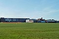 Emerson Park School - geograph.org.uk - 2349620.jpg 640 × 428; 67 KB
 Fairy Tales Pre School - geograph.org.uk - 2597702.jpg 640 × 430; 62 KB
 Harold Court Primary School - geograph.org.uk - 2454974.jpg 640 × 428; 87 KB
 Harwood Hall, Corbets Tey, Upminster - geograph.org.uk - 39256.jpg 640 × 480; 108 KB
 Primary school near Hacton Bridge - geograph.org.uk - 2603838.jpg 640 × 430; 86 KB
 Sacred Heart of Mary Girls' School Upminster.JPG 4,278 × 3,210; 3.35 MB
 Sacred Heart School, Upminster - geograph.org.uk - 147575.jpg 640 × 514; 133 KB
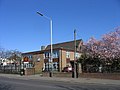 St. Joseph's School, Upminster - geograph.org.uk - 147572.jpg 640 × 480; 79 KB


