Category:SVG maps of Chad
Jump to navigation
Jump to search
Subcategories
This category has the following 4 subcategories, out of 4 total.
Media in category "SVG maps of Chad"
The following 20 files are in this category, out of 20 total.
-
 Administrative regions of Chad.svg 899 × 1,349; 192 KB
-
 CAR-Chad-CameroonLocator.svg 626 × 643; 1.23 MB
-
 Carte administrative de N'Djaména.svg 512 × 453; 5.32 MB
-
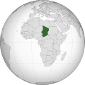 Chad (orthographic projection).svg 553 × 553; 213 KB
-
 Chad adm location map.svg 899 × 1,349; 215 KB
-
 Chad Location map.svg 442 × 695; 45 KB
-
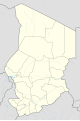
 Chad regions map-numbered 2008-02.svg 899 × 1,349; 181 KB
-
 Fezzan Campaign map1.svg 970 × 1,727; 309 KB
-
 Koppen-Geiger Map TCD future.svg 1,054 × 850; 437 KB
-
 Koppen-Geiger Map TCD present.svg 1,054 × 850; 443 KB
-
 Langue herdé.svg 904 × 1,352; 292 KB
-
 Langue mesmé.svg 904 × 1,352; 292 KB
-
 Langue ngeté.svg 904 × 1,352; 292 KB
-
 Langue pévé.svg 904 × 1,352; 292 KB
-
 Langues masa du Sud.svg 904 × 1,352; 292 KB
-
 Location Chad AU Africa.svg 1,400 × 1,300; 2.17 MB
-
 Mapa do Chade (OCHA).svg 254 × 254; 377 KB
-
 Sahara ecoregion.svg 700 × 500; 181 KB
-
 SVG-Koort Tschad.svg 300 × 425; 66 KB
-
 مناطق تشاد.svg 899 × 1,349; 193 KB


.svg)


.svg)


