Category:Red Run Covered Bridge
Jump to navigation
Jump to search
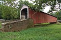
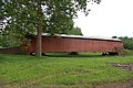
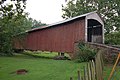
English: Red Run Covered Bridge, also known as Oberhaltzer's Covered Bridge, a covered, Burr arch truss bridge in Brecknock Township, Lancaster County, Pennsylvania, USA. It was built in 1866 and is 107 feet (33 m) long and 15 feet (4.6 m) wide. World Guide to Covered Bridges #38-36-10.
| Object location | | View all coordinates using: OpenStreetMap |
|---|
|
This is a category about a place or building that is listed on the National Register of Historic Places in the United States of America. Its reference number is 80003539. |
bridge in Pennsylvania, United States  | |||||
| Upload media | |||||
| Instance of | |||||
|---|---|---|---|---|---|
| Location | Brecknock Township, Lancaster County, Pennsylvania | ||||
| Crosses |
| ||||
| Heritage designation | |||||
 | |||||
Media in category "Red Run Covered Bridge"
The following 8 files are in this category, out of 8 total.
-
 Red Run Covered Bridge 3000px.jpg 3,000 × 2,000; 3.41 MB
-
 Red Run Covered Bridge Dot Map.png 1,988 × 1,806; 197 KB
-
 Red Run Covered Bridge from above - Oct 2020.jpg 2,048 × 1,536; 1.7 MB
-
 Red Run Covered Bridge from above -2 - Oct 2020.jpg 2,048 × 1,536; 1.61 MB
-
 Red Run Covered Bridge Front 3008px.jpg 3,008 × 2,000; 2.9 MB
-
 Red Run Covered Bridge Side 3008px.jpg 3,008 × 2,000; 2.8 MB
-
 Red Run Covered Bridge Three Quarters View 3008px.jpg 3,008 × 2,000; 2.69 MB
-
 Red Run Covered Bridge Three Quarters Wide 3008px.jpg 3,008 × 1,803; 2.34 MB


Categories:
- Bridges in the United States completed in 1866
- Built in Pennsylvania in 1866
- Covered bridges in Lancaster County, Pennsylvania
- Bridges on the National Register of Historic Places in Lancaster County, Pennsylvania
- Through truss bridges in Pennsylvania
- Red covered bridges in the United States
- Roads in Brecknock Township, Lancaster County, Pennsylvania
- Covered bridges on the National Register of Historic Places in Pennsylvania