Category:Radlett
Jump to navigation
Jump to search
English: Radlett is a large village located north of London in the county of Hertfordshire between St Albans and Elstree on Watling Street with a population of approximately 8,000. It is located in the council district of Hertsmere and is covered by two wards, Aldenham East and Aldenham West.
Nederlands: Radlett is een plaats in het Engelse graafschap Hertfordshire. Het dorp bevindt zich in het district Hertsmere. Het dorp telt 8034 inwoners.
town in Hertfordshire, England  | |||||
| Upload media | |||||
| Instance of | |||||
|---|---|---|---|---|---|
| Location | Hertsmere, Hertfordshire, East of England, England | ||||
 | |||||
Subcategories
This category has the following 6 subcategories, out of 6 total.
C
N
- Netherwylde Farm, Aldenham (3 F)
R
- Radlett murder (6 F)
- Radlett railway station (19 F)
- Radlett Reform Synagogue (2 F)
T
- Tabard Rugby Football Club (1 F)
Media in category "Radlett"
The following 44 files are in this category, out of 44 total.
-
 A change of road name - geograph.org.uk - 38096.jpg 640 × 480; 33 KB
-
 Businesses on west side of Watling Street, Radlett - Geograph-2252744-by-John-Copleston.jpg 2,592 × 1,728; 3.89 MB
-
 Butterfly Lane at the entrance to Slade Farm - geograph.org.uk - 3129656.jpg 2,048 × 1,536; 1.49 MB
-
 Cattle at Blackbirds Farm, Radlett - geograph.org.uk - 118266.jpg 640 × 480; 121 KB
-
 Curo Park Commercial Entrance.jpg 2,304 × 1,728; 1.02 MB
-
 Fields near Elstree - geograph.org.uk - 116872.jpg 640 × 480; 168 KB
-
 High Cross, Oakridge Lane - geograph.org.uk - 89404.jpg 640 × 480; 112 KB
-
 House at Radlett (first floor plan).jpg 2,368 × 1,078; 335 KB
-
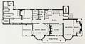 House at Radlett (ground floor plan).jpg 2,308 × 1,196; 384 KB
-
 House at Radlett.jpg 2,510 × 1,156; 638 KB
-

-
 Nightingdale Court - geograph.org.uk - 968773.jpg 640 × 495; 89 KB
-
 Park Reservoir - panoramio.jpg 4,752 × 3,168; 7 MB
-
 Porters Park Golf Club House, Radlett - geograph.org.uk - 38089.jpg 640 × 480; 19 KB
-
 Private House in The Avenue Radlett - geograph.org.uk - 38085.jpg 640 × 480; 24 KB
-
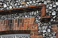 Flint & brick detail.JPG 3,888 × 2,592; 3.95 MB
-
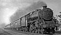
 Radlett 2 railway geograph-2608812-by-Ben-Brooksbank.jpg 2,392 × 1,382; 810 KB
-
 Radlett Brook - geograph.org.uk - 1265021.jpg 640 × 480; 113 KB
-
 Radlett Brook - geograph.org.uk - 1265048.jpg 640 × 480; 132 KB
-
 Radlett Brook - geograph.org.uk - 1266362.jpg 640 × 480; 140 KB
-
 Radlett Brook, Railway bridge - geograph.org.uk - 1266471.jpg 640 × 480; 112 KB
-
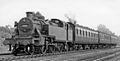 Radlett down local geograph-2818252-by-Ben-Brooksbank.jpg 2,394 × 1,211; 1.27 MB
-
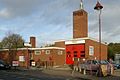 Radlett fire station - geograph.org.uk - 279912.jpg 640 × 427; 210 KB
-
 Radlett geograph-2600521-by-Ben-Brooksbank.jpg 2,393 × 1,396; 515 KB
-
 Radlett Main Building (2).jpg 1,600 × 1,200; 610 KB
-
 Radlett, Access road to Kendal Hall Farm - geograph.org.uk - 89391.jpg 640 × 480; 188 KB
-

-
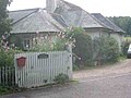
 Radlett, Flint Cottages - geograph.org.uk - 1262961.jpg 640 × 480; 86 KB
-
 Radlett, Kendals Close - geograph.org.uk - 89382.jpg 640 × 480; 82 KB
-
 Radlett, Little Kendals Wood - geograph.org.uk - 89383.jpg 640 × 480; 115 KB
-

-
 Radlett, The Oakway, Watling Street - geograph.org.uk - 1263065.jpg 640 × 480; 74 KB
-
 Radlett, The Ridgeway - geograph.org.uk - 89379.jpg 640 × 480; 109 KB
-
 Radlett, Tykes Water - geograph.org.uk - 89392.jpg 640 × 480; 158 KB
-
 Radlett, Watling Street (1) - geograph.org.uk - 65195.jpg 640 × 425; 91 KB
-
 Radlett, Watling Street (2) - geograph.org.uk - 65199.jpg 640 × 425; 91 KB
-
 Radlett, Watling Street - geograph.org.uk - 89387.jpg 640 × 480; 120 KB
-
 Radlett, Williams Way - geograph.org.uk - 89393.jpg 640 × 480; 141 KB
-
 Railway bridge near Radlett - geograph.org.uk - 93991.jpg 640 × 480; 102 KB
-
 Sewage Works near Radlett - geograph.org.uk - 116875.jpg 640 × 480; 168 KB
-
 Sign at end of the upmarket estate. - geograph.org.uk - 37012.jpg 640 × 480; 22 KB
-

-
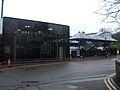
 The office (51966195573).jpg 4,032 × 3,024; 2.86 MB
-


.jpg)
.jpg)


.jpg)


_-_geograph.org.uk_-_65195.jpg)
_-_geograph.org.uk_-_65199.jpg)


.jpg)
