Category:Raadhuis (Hoogeveen)
Jump to navigation
Jump to search
| Object location | | View all coordinates using: OpenStreetMap |
|---|
 | |||||
| Upload media | |||||
| Instance of | |||||
|---|---|---|---|---|---|
| Location | Hoogeveen, Drenthe, Netherlands | ||||
| Street address |
| ||||
| Located on street |
| ||||
| Heritage designation |
| ||||
 | |||||
Nederlands: Raadhuis
|
This is a category about rijksmonument number 507304
|
| Address |
|
Media in category "Raadhuis (Hoogeveen)"
The following 31 files are in this category, out of 31 total.
-
 20200622 gemeentehuis Hoogeveen.jpg 5,184 × 3,456; 3.33 MB
-
 20200622 gemeentehuis2 Hoogeveen.jpg 5,184 × 3,456; 3.17 MB
-
 20200622 wapen Hoogeveen gemeentehuis Hoogeveen.jpg 5,184 × 3,456; 4.41 MB
-
 Achtergevel van dienstwoning nabij raadhuis - Hoogeveen - 20399658 - RCE.jpg 1,200 × 799; 193 KB
-
 Achterzijde raadhuis - Hoogeveen - 20399651 - RCE.jpg 1,200 × 799; 212 KB
-

-
 Detail van kelderraam aan de voorzijde - Hoogeveen - 20399662 - RCE.jpg 1,200 × 799; 237 KB
-
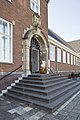 Entreepartij gezien vanaf de linkerzijde - Hoogeveen - 20399667 - RCE.jpg 799 × 1,200; 217 KB
-
 Entreepartij, voorzijde - Hoogeveen - 20399670 - RCE.jpg 1,200 × 799; 235 KB
-
 Exterieur overzicht voorgevel, klokkentoren - Hoogeveen - 20322354 - RCE.jpg 1,200 × 929; 202 KB
-
-
 Hoogeveen - Gemeentehuis Hoogeveen - Rijksmonument 507304.JPG 4,272 × 2,848; 2.64 MB
-
 Linkerachtergevel - Hoogeveen - 20399657 - RCE.jpg 799 × 1,200; 200 KB
-

-
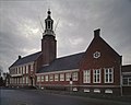 Overzicht voorgevel met klokkentoren - Hoogeveen - 20369124 - RCE.jpg 1,200 × 956; 156 KB
-

-
 Overzicht voorzijde - Hoogeveen - 20399641 - RCE.jpg 1,200 × 799; 176 KB
-

-
 Raadhuis Hoogeveen.JPG 428 × 323; 32 KB
-
 Ramen op de bel-etage aan de voorzijde - Hoogeveen - 20399664 - RCE.jpg 1,200 × 799; 176 KB
-
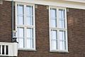 Ramen op de eerste verdieping - Hoogeveen - 20399666 - RCE.jpg 1,200 × 799; 180 KB
-

-
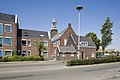
 Situering in het straatbeeld - Hoogeveen - 20399640 - RCE.jpg 1,200 × 799; 141 KB
-
 Situering met link op de hoek huisnummer 3 - Hoogeveen - 20399643 - RCE.jpg 1,200 × 799; 154 KB
-
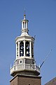 Torenspits - Hoogeveen - 20399673 - RCE.jpg 799 × 1,200; 100 KB
-

-
 Voorgevel - Hoogeveen - 20399648 - RCE.jpg 1,200 × 799; 121 KB
-
 Voorzijde - Hoogeveen - 20399642 - RCE.jpg 1,200 × 799; 189 KB
-
 Wapensteen boven entreepartij - Hoogeveen - 20399672 - RCE.jpg 1,200 × 799; 245 KB
-

-


