Category:RTCN Jemiołów
Jump to navigation
Jump to search
| Object location | | View all coordinates using: OpenStreetMap |
|---|
place  | |||||
| Upload media | |||||
| Instance of | |||||
|---|---|---|---|---|---|
| Location | Jemiołów, Gmina Łagów, Świebodzin County, Lubusz Voivodeship, Poland | ||||
| Owned by |
| ||||
| Inception |
| ||||
| Height |
| ||||
| Elevation above sea level |
| ||||
 | |||||
Media in category "RTCN Jemiołów"
The following 5 files are in this category, out of 5 total.
-
 Guys Jemiolow TV Mast16092015.JPG 4,905 × 3,270; 7.69 MB
-
 Jemiolow Telecommunication Tower16092015.JPG 3,270 × 4,905; 8.78 MB
-
 Jemiolow TV Mast Pinnacle16092015.JPG 3,428 × 5,142; 8.48 MB
-
 RTCN Jemiolow16092015 1.JPG 3,314 × 4,971; 9.01 MB
-
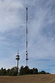
 RTCN Jemiołów.jpg 1,704 × 2,272; 256 KB


