Category:R.K.Parochie v.d. Heilige Martinus (Sneek)
Jump to navigation
Jump to search
| Object location | | View all coordinates using: OpenStreetMap |
|---|
 | |||||
| Upload media | |||||
| Instance of | |||||
|---|---|---|---|---|---|
| Part of | |||||
| Named after | |||||
| Location | Sneek, Súdwest-Fryslân, Friesland, Netherlands | ||||
| Architect | |||||
| Heritage designation |
| ||||
 | |||||
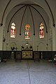
Nederlands: R.K.Parochie v.d. Heilige Martinus, Grafkapel
|
This is a category about rijksmonument number 514088
|
| Address |
|
Media in category "R.K.Parochie v.d. Heilige Martinus (Sneek)"
The following 3 files are in this category, out of 3 total.
-
 2601Sneek.JPG 4,000 × 3,000; 6.84 MB
-
 Kapel bij Leeuwarderweg 83, Sneek.jpg 2,304 × 3,456; 3.18 MB
-
 Overzicht begraafplaats met grafkapel - Sneek - 20334665 - RCE.jpg 1,190 × 1,200; 334 KB

