Category:Rønne bagfyr
Jump to navigation
Jump to search
| Object location | | View all coordinates using: OpenStreetMap |
|---|
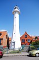
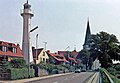
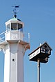
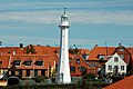
English: Rønne Lighthouse
lighthouse in Denmark ,_by_Klugschnacker_in_Wikipedia_(4).JPG) | |||||
| Upload media | |||||
| Instance of | |||||
|---|---|---|---|---|---|
| Location | Rønne, Bornholm regional municipality, Capital Region of Denmark, Denmark | ||||
| Service entry |
| ||||
| Service retirement |
| ||||
| Inception |
| ||||
| Height |
| ||||
 | |||||
Media in category "Rønne bagfyr"
The following 15 files are in this category, out of 15 total.
-
 20090817 Rønne 05.JPG 4,272 × 2,848; 2.9 MB
-
 20090817 Rønne 09.JPG 2,848 × 4,272; 2.04 MB
-
 20090817 Rønne 36.JPG 2,848 × 4,272; 4.11 MB
-
 Denmark 2016-08-16 (29341328204).jpg 2,998 × 4,445; 448 KB
-
 DNK - Rønne - Bornholm 005.jpg 2,000 × 3,000; 2.82 MB
-
 Havnebakken, Rønne, Bornholm (2012-07-03), by Klugschnacker in Wikipedia (5).jpg 3,966 × 2,641; 1.07 MB
-
 Latarnia morska w Ronne - panoramio.jpg 3,072 × 2,304; 1,012 KB
-
 Latarnia w Ronne - panoramio.jpg 1,382 × 1,037; 248 KB
-
 Roone latarnia morska.jpg 1,722 × 2,689; 707 KB
-
 Rönne Bagfyr 07-1988 (2).JPG 2,004 × 1,391; 562 KB
-
 Rönne Bagfyr 07-1988.JPG 1,122 × 1,539; 307 KB
-
 Rønne Lighthouse, Bornholm, Denmark, Northern Europe-2.jpg 2,678 × 4,000; 2.51 MB
-
 Rønne Lighthouse, Bornholm, Denmark, Northern Europe.jpg 4,000 × 2,660; 4.46 MB
-
 Rønne, Bornholm (2012-07-03), by Klugschnacker in Wikipedia (4).JPG 2,404 × 3,604; 845 KB
-
 Wizytówka miasta - panoramio.jpg 2,048 × 1,536; 837 KB


.jpg)

,_by_Klugschnacker_in_Wikipedia_(5).jpg)


.JPG)


