Category:Playa de Santiago
Jump to navigation
Jump to search
| Camera location | | View all coordinates using: OpenStreetMap |
|---|
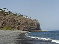
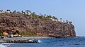
English: Pictures of the beach Playa de Santiago in Playa de Santiago (Alajeró) in the south of La Gomera. Near to the harbour Puerto de Santiago
Nederlands: Afbeeldingen van het strand Playa de Santiago in Playa de Santiago (Alajeró) in het zuiden van La Gomera. Gelegen nabij de haven Puerto de Santiago
human settlement  | |||||
| Upload media | |||||
| Instance of | |||||
|---|---|---|---|---|---|
| Location | Canary Islands, Spain | ||||
| Population |
| ||||
| Elevation above sea level |
| ||||
 | |||||
Media in category "Playa de Santiago"
The following 15 files are in this category, out of 15 total.
-
 2015 La Gomera 313 150629 Playa de Santiago Hotel Jardin Tecina.JPG 3,264 × 2,448; 2.75 MB
-
 2015 La Gomera 397 150702 Playa de Santiago Las Trincheras.JPG 3,264 × 2,448; 2.92 MB
-
 Gomera 2012 232a.JPG 3,995 × 2,128; 1.42 MB
-
 Hotel Jardin Tecina Playa de Santiago 2 (8553302004).jpg 4,560 × 3,279; 7.52 MB
-
 House - Playa Santiago 01.jpg 5,665 × 3,483; 16.58 MB
-
 House - Playa Santiago 02.jpg 3,330 × 5,432; 11.16 MB
-
 La Gomera, GR 132 (16).jpg 4,867 × 3,245; 8.53 MB
-
 Luftbild vom Hafen Puerto de Playa Santiago auf La Gomera, Spanien (48293799262).jpg 4,125 × 2,745; 9.15 MB
-
 Playa de Santiago (8524842683).jpg 5,142 × 3,390; 10.51 MB
-
 Playa Santiago - La Gomera 01.jpg 5,721 × 3,641; 15.32 MB
-
 Tecina - Playa Santiago - La Gomera 01.jpg 5,990 × 3,366; 14.86 MB
-
 Tomato packaging worker - La Gomera 01.jpg 3,598 × 5,402; 15.45 MB
-
 Tomato packaging worker - La Gomera 02.jpg 3,542 × 5,824; 13.61 MB
-
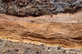 Volcanic layers - Playa Santiago 01.jpg 6,000 × 4,000; 20.8 MB
-
 Windows - Playa Santiago 01.jpg 5,791 × 3,879; 18.48 MB


.jpg)


.jpg)
.jpg)
.jpg)


