Category:Petroleum-related maps
Jump to navigation
Jump to search
Subcategories
This category has the following 5 subcategories, out of 5 total.
Media in category "Petroleum-related maps"
The following 31 files are in this category, out of 31 total.
-
 Block 52 Offshore Map Suriname (Oil and Gas).png 8,420 × 5,950; 1.22 MB
-
 Cuadro Comparativo Expropiación vs. Captura Regulatoria.JPG 699 × 548; 108 KB
-
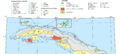 Cuban oil fields.png 1,208 × 547; 84 KB
-
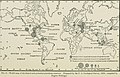
 Die türkisch-persischen Erdölvorkommen (1919) (14781416824).jpg 3,370 × 2,096; 825 KB
-

-
 Early geophysical papers of the Society of Exploration Geophysicists (1947) (20500655533).jpg 2,082 × 2,974; 1,003 KB
-

-

-

-
 Early geophysical papers of the Society of Exploration Geophysicists (1947) (21111734062).jpg 1,980 × 3,160; 1,002 KB
-
-

-
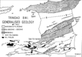 Generalized geology of Trinidad.png 814 × 570; 115 KB
-
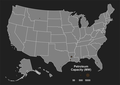
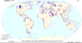
 Interstate Oil and Gas Compact Commission members map.svg 959 × 593; 32 KB
-
 Oil crops.png 1,425 × 625; 41 KB
-
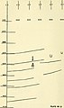
 Oil investigations in 1917 and 1918 (1919) (14771339984).jpg 1,960 × 3,412; 1.18 MB
-
 Oil investigations in 1917 and 1918 (1919) (14773713155).jpg 2,532 × 3,604; 1.31 MB
-
 Plant map Petroleum.png 2,550 × 1,800; 404 KB
-

-

-

-

-

-

-

-
 The economics of petroleum (1921) (14760094976).jpg 2,784 × 1,778; 478 KB
-
 The economics of petroleum (1921) (14779947251).jpg 2,768 × 1,836; 349 KB
-
 The economics of petroleum (1921) (14783136745).jpg 2,800 × 1,900; 555 KB
-
 The oil fields of Crawford and Lawrence counties (1913) (14596031967).jpg 2,408 × 3,956; 1.43 MB
-
 Timor Gap map.PNG 1,495 × 810; 70 KB
-
 World petroleum systems.png 6,304 × 3,371; 566 KB
.png)


_(14781416824).jpg)
_(20499244014).jpg)
_(20500655533).jpg)
_(20500813833).jpg)
_(20933997698).jpg)
_(20934007818).jpg)
_(21111734062).jpg)
_(21121526545).jpg)
_(21129632951).jpg)


_(14771339984).jpg)
_(14773713155).jpg)

_(14591356730).jpg)
_(14591402348).jpg)
_(14591426418).jpg)
_(14755045096).jpg)
_(14777699452).jpg)
_(14797920523).jpg)
_(14760094976).jpg)
_(14779947251).jpg)
_(14783136745).jpg)
_(14596031967).jpg)


_(14591378480).jpg)