Category:PNG created with ArcGIS Pro
Jump to navigation
Jump to search
Media in category "PNG created with ArcGIS Pro"
The following 39 files are in this category, out of 39 total.
-
 2017 Arizona wildfires.png 3,200 × 3,200; 750 KB
-
 Albemarle and Chesapeake Canal.png 2,000 × 2,000; 337 KB
-
 Alberta Clipper pipeline.png 2,500 × 1,500; 305 KB
-
 AssawomanCanal.png 2,000 × 2,000; 178 KB
-
 Atlantic Coast Bicycle Route.png 1,000 × 2,000; 192 KB
-
 Boundary Fire (2017) alt.png 3,200 × 3,200; 2.21 MB
-
 Boundary Fire (2017).png 3,200 × 3,200; 2.08 MB
-
 Canaveral Barge Canal.png 2,000 × 2,000; 255 KB
-
 CapeMayCanal.png 2,000 × 2,000; 188 KB
-
 ChestertownArmoryArea.png 2,500 × 2,500; 1.52 MB
-
 Columbus Circle Map.png 2,000 × 2,000; 287 KB
-
 DCStreetsLabels.png 5,000 × 5,000; 2.92 MB
-
 DismalSwampCanal.png 2,000 × 2,000; 324 KB
-
 Dulles Technology Corridor.png 2,500 × 1,500; 243 KB
-
 Goodwin Fire.png 3,200 × 3,200; 3.97 MB
-
 Great Fire of London Map.png 2,550 × 1,500; 342 KB
-
 Great Fire of London Monday.png 2,125 × 1,250; 151 KB
-
 Great Fire of London Sunday.png 2,125 × 1,250; 137 KB
-
 Great Fire of London Tuesday.png 2,125 × 1,250; 190 KB
-
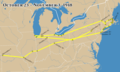
 Great Lakes 1913 Storm Shipwrecks.png 4,000 × 2,400; 799 KB
-
 GreatLoop.png 2,000 × 3,000; 529 KB
-
 Gulf Intracoastal Waterway.png 1,500 × 1,000; 147 KB
-
 Haulover Canal.png 2,000 × 2,000; 254 KB
-
 Lake Estancia and Lake Willard.png 2,000 × 2,500; 4.05 MB
-
 LevantineArabic.png 2,000 × 3,500; 178 KB
-
 LewesAndRehobothCanal.png 2,000 × 2,000; 219 KB
-
 Marathon of Hope Map.png 2,500 × 1,500; 282 KB
-
 Miami Canal.png 2,000 × 2,000; 173 KB
-
 MidlandsTrailWVMap.png 1,500 × 1,000; 1.69 MB
-
 PointeDuHoc.png 3,200 × 2,400; 276 KB
-
 PointPlesantCanal.png 2,000 × 2,000; 205 KB
-
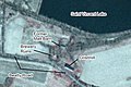 SaintVincentBrewerySite.jpg 900 × 600; 137 KB
-
 StateNamedStreets.png 2,500 × 2,500; 807 KB
-
 Tamiami Canal.png 2,000 × 2,000; 165 KB
-
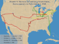 Truman1948Stops.png 4,800 × 3,600; 1.42 MB
-
 TrumanOct23Nov3.png 3,000 × 1,800; 524 KB
-
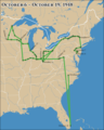 TrumanOct6Oct19.png 2,400 × 3,000; 639 KB
-
 TrumanSept6Oct1.png 4,800 × 3,600; 1.32 MB
-
 W&OD Trail Map.png 2,500 × 1,500; 313 KB


_alt.png)
.png)


