Category:Old maps of Wales
Jump to navigation
Jump to search
Constituent countries of the United Kingdom: England · Northern Ireland · Scotland · Wales – British Crown dependencies: Bailiwick of Guernsey · Isle of Man · Jersey
British overseas territories: Bermuda · Falkland Islands · Gibraltar · Pitcairn Islands · South Georgia and the South Sandwich Islands
British overseas territories: Bermuda · Falkland Islands · Gibraltar · Pitcairn Islands · South Georgia and the South Sandwich Islands
Use the appropriate category for maps showing all or a large part of Wales. See subcategories for smaller areas:
| If the map shows | Category to use |
|---|---|
| Wales on a recently created map | Category:Maps of Wales or its subcategories |
| Wales on a map created more than 70 years ago | Category:Old maps of Wales or its subcategories |
| the history of Wales on a recently created map | Category:Maps of the history of Wales or its subcategories |
| the history of Wales on a map created more than 70 years ago | Category:Old maps of the history of Wales or its subcategories |
Subcategories
This category has the following 20 subcategories, out of 20 total.
*
C
E
G
H
Media in category "Old maps of Wales"
The following 35 files are in this category, out of 35 total.
-

-

-
-
 55 of 'Hartley's illustrated coaching guide to North Wales' (11202381105).jpg 1,952 × 1,317; 798 KB
-
 A map of Ireland Wellcome V0049913.jpg 3,313 × 2,475; 4.08 MB
-
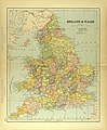
 A short history of England and the British Empire (1915) (14580879807).jpg 1,996 × 2,720; 818 KB
-
 Accuratissima Angliae regni et Walliae principatus descriptio - CBT 6604533.jpg 5,106 × 4,749; 8.66 MB
-

-
 Bacon's Map of Wales, from the ordnance surveys - by Edw. Weller... - btv1b53022852h.jpg 8,639 × 10,680; 17.18 MB
-
 Bowen - Britannica Depicta (Cardigan).jpg 500 × 764; 121 KB
-
 Caermardi Comitatus in Quo Dimetae olim habitarunt.jpg 2,732 × 2,315; 2.01 MB
-
 Cassell & Co.(1891) p03.257 - Map of Flintshire.jpg 1,137 × 1,042; 344 KB
-
 Cassell & Co.(1898) p05.257 - Map of Flintshire.jpg 1,148 × 1,077; 392 KB
-
 Dyfi Hills.svg 512 × 510; 6.5 MB
-
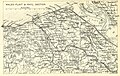
 EB1911 Water Supply - Welsh Reservoir Sites (bottom).jpg 2,716 × 2,082; 1.54 MB
-
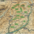
 EB1911 Water Supply - Welsh Reservoir Sites (top).jpg 2,704 × 2,062; 1.75 MB
-
 England 1828.jpg 5,416 × 6,697; 7.4 MB
-
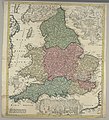
 England Und Wales.jpg 5,656 × 4,548; 7.97 MB
-
 England und Wales.jpg 5,636 × 4,587; 8.07 MB
-
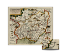
 Galles. Monmouth. Carte. Morden.jpg 509 × 391; 103 KB
-
 Llangennech Caermardi Map.png 2,732 × 2,315; 6.45 MB
-
-
 Map c1577.jpg 2,619 × 2,139; 947 KB
-
 MAp Hugh.PNG 711 × 751; 1,014 KB
-
 Map of England and Wales Wellcome V0049911.jpg 2,494 × 2,815; 3.25 MB
-
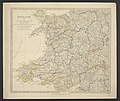
 Map of England and Wales.jpg 2,931 × 3,542; 2.37 MB
-
 Map Sampler (Wales), 18th century (CH 18564361).jpg 4,096 × 2,959; 13.08 MB
-
 The south part of Great Britain, called England and Wales (NYPL b15369994-1630442).tiff 7,230 × 5,256; 108.72 MB
-

-
 OS old series 1 63360 36.jpg 9,047 × 6,137; 14.2 MB
-
 OS old series 1 63360 41.jpg 8,954 × 6,325; 14.22 MB
-
 Powys.png 844 × 925; 31 KB
-
 Principatus Walliae pars australis vulgo South-Wales - CBT 6599377.jpg 5,739 × 4,589; 7.44 MB
-
 Verwaltungskarte von England 02.jpg 5,249 × 4,407; 8.35 MB
-
 Wenceslas Hollar - South Wales.jpg 3,513 × 2,404; 2.78 MB
.jpg)
._30_illustrations%27_(11195985615).jpg)
.jpg)
.jpg)

_(14580879807).jpg)


.jpg)

_p03.257_-_Map_of_Flintshire.jpg)
_p05.257_-_Map_of_Flintshire.jpg)

.jpg)
.jpg)


,_18th_century_(CH_18564361).jpg)
.jpg)


