Category:Old maps of Toulon
Jump to navigation
Jump to search
Subcategories
This category has the following 6 subcategories, out of 6 total.
T
Media in category "Old maps of Toulon"
The following 48 files are in this category, out of 48 total.
-
 "Plan de la Baye et Rades de Toulon" (21622041924).jpg 3,267 × 2,429; 1.78 MB
-
 Marseilles by Piri Reis.jpg 587 × 810; 201 KB
-
 Bay of Touloun; Bay of Marcellia. NYPL1640687.tiff 7,230 × 5,428; 112.28 MB
-
 Plan de la ville ... de Toulon (BM 1859,0514.341.132).jpg 2,500 × 1,836; 977 KB
-

-
 Plan of Rochfort & Rochel with the Islands of Res, Oleron, Aix, &c (BM 1871,1209.133).jpg 2,039 × 2,500; 1.09 MB
-
 The Road of Toulon with the adjacent Country (BM 1871,1209.134).jpg 2,500 × 2,011; 1.1 MB
-

-
 1840 S.D.U.K. Map or City Plan of Toulon, France - Geographicus - Tulon-SDUK-1840.jpg 2,750 × 2,200; 1.27 MB
-
 Admiralty Chart No 2607 France south coast Marseille to Agay Road, Published 1893.jpg 12,321 × 8,326; 10.33 MB
-
 66 of 'La France Illustrée- géographie générale ... Par F. J' (11291697883).jpg 1,840 × 880; 440 KB
-

-
 Admiralty Chart No 2608 Approaches to Toulon, Published 1893.jpg 12,268 × 8,299; 10.28 MB
-
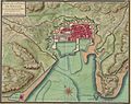
 Belagerung von Toulon 1707.jpg 576 × 454; 109 KB
-
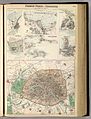
 Brockhaus' Konversations-Lexikon (1892) (14782209394).jpg 2,592 × 1,726; 717 KB
-
 Cerco de Toulon 1793.jpg 749 × 839; 267 KB
-
 Fullarton, French Ports & Harbours, and Plan of Paris, 1872 - David Rumsey.jpg 6,086 × 7,985; 10.53 MB
-
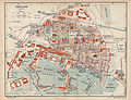
 Karte der Umgebung von Toulon.jpg 545 × 495; 97 KB
-
 Maximilien-de-Béthune-Pierre-Mathurin-Memoirs-of-Maximilian-de-Bethune MG 9414.tif 4,362 × 3,618; 45.19 MB
-

-

-

-
 Plan de Toulon et de son arsenal en 1700.jpg 1,817 × 1,437; 480 KB
-
 Plan of the arsenal of Toulon RMG F3843.jpg 5,055 × 6,400; 7.71 MB
-
 Plan of the arsenal of Toulon RMG F3843.tiff 6,400 × 5,055; 92.56 MB
-
 Plan Tw Toulon 1928.jpg 2,984 × 2,313; 1.73 MB
-
 Plan von der Stadt und Vestung Toulon nebst der umliegenden Gegend.jpg 5,437 × 4,196; 6.59 MB
-
 Plans des ports de France (1777) - Environs de Toulon.jpg 9,982 × 4,830; 5.65 MB
-
 Plans des ports de France (1777) - Rade de Toulon.jpg 6,518 × 4,785; 4.65 MB
-
 The Harbour of Marseilles by Ottoman Admiral Piri Reis 1526.jpg 2,642 × 1,938; 777 KB
-
 Toulon - btv1b10679949p.jpg 4,120 × 2,912; 1.86 MB
-
 Toulon - btv1b52502919w.jpg 11,569 × 8,620; 10.15 MB
-
 Toulon - btv1b530337878.jpg 6,126 × 4,138; 3.7 MB
-
 Toulon - btv1b84399973.jpg 9,035 × 6,978; 9.36 MB
-
 Toulon - btv1b8440390m.jpg 8,470 × 6,217; 6.77 MB
-
 Toulon - btv1b8444969h.jpg 4,572 × 6,185; 2.83 MB
-

-
 Toulon et ses faubourgs, carte - dressée... par Antelme - btv1b8440214w.jpg 7,234 × 5,107; 4.75 MB
-
 Toulon et ses faubourgs, carte - dressée... par Antelme - btv1b8440278t.jpg 7,882 × 5,135; 5.03 MB
-
 Toulon Harbour.png 4,480 × 3,630; 26.08 MB
-

-

-
 Toulon-1921-Carte-27.jpg 2,386 × 1,832; 1.39 MB
-
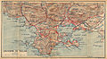 Toulon-environs-1921-Carte-29.jpg 3,312 × 1,816; 1.77 MB
-
 Toulon-Le Mourillon-1921-Carte-28.jpg 965 × 601; 242 KB
-
 Toulon. 1 - 8.000 - E. Fonné et Quémy. Dess. - btv1b53192513m.jpg 10,218 × 6,713; 11.76 MB
-
 Toulon. Plan du Fort de l'Eguillette - btv1b8493962p.jpg 8,252 × 6,125; 5.68 MB
-
 Toulon. Projets de 1754 - btv1b8440375x.jpg 8,962 × 6,707; 6.7 MB
.jpg)

.jpg)
_-_dessin%C3%A9s_par..._-_btv1b52503974g_(067_of_106).jpg)
.jpg)
.jpg)
%27_(11262710984).jpg)


.jpg)
.jpg)


_(14782209394).jpg)


,_RP-P-OB-83.411.jpg)


_-_Environs_de_Toulon.jpg)
_-_Rade_de_Toulon.jpg)


