Category:Old maps of Entebbe
Jump to navigation
Jump to search
Media in category "Old maps of Entebbe"
The following 8 files are in this category, out of 8 total.
-
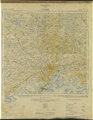 Entebbe- Uganda, Africa 1- 250,000 WDL9942.png 1,024 × 1,318; 2.79 MB
-
 Rapid Road Sketch from Entebbe to the Boundary. (WOOS-14-9-1).jpg 8,135 × 6,510; 24.46 MB
-
 Rapid Road Sketch from Entebbe to the Boundary. (WOOS-14-9-2).jpg 8,758 × 6,270; 26.99 MB
-
 Rapid Road Sketch from Entebbe to the Boundary. (WOOS-14-9-3).jpg 7,601 × 6,552; 26.01 MB
-
 Rapid Road Sketch from Entebbe to the Boundary. (WOOS-14-9-4).jpg 8,741 × 6,247; 25.73 MB
-
 Rapid Road Sketch from Entebbe to the Boundary. (WOOS-14-9-5).jpg 8,139 × 6,444; 23.54 MB
-
 Rapid Road Sketch from Entebbe to the Boundary. (WOOS-14-9-6).jpg 8,498 × 6,325; 27.39 MB
-
 Rapid Road Sketch from Entebbe to the Boundary. (WOOS-14-9-7).jpg 7,658 × 6,508; 26.68 MB

.jpg)
.jpg)
.jpg)
.jpg)
.jpg)
.jpg)
.jpg)