Category:October 2005 in County Antrim
Jump to navigation
Jump to search
English: Images taken in County Antrim, Northern Ireland in this month of 2005 (not the date of the upload).
| Jan | Feb | Mar | Apr | May | Jun | Jul | Aug | Sep | Oct | Nov | Dec | ||
| ← | 1 | 3 | 8 | 8 | 35 | 5 | 13 | 22 | 35 | 38 | 68 | 35 | → |
|---|
Media in category "October 2005 in County Antrim"
The following 38 files are in this category, out of 38 total.
-
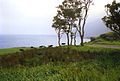
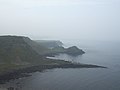 Antrim coast, near Giants Causeway - geograph.org.uk - 69651.jpg 640 × 480; 63 KB
-
 Ballycarry Station. - geograph.org.uk - 71081.jpg 640 × 480; 124 KB
-

-

-
-
 Broomhedge Masonic Hall - geograph.org.uk - 70092.jpg 640 × 480; 87 KB
-
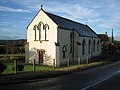
 Broomhedge Methodist Church - geograph.org.uk - 70090.jpg 480 × 640; 120 KB
-
 Cargycreevy Presbyterian Church - geograph.org.uk - 70849.jpg 640 × 480; 87 KB
-
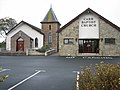 Carr Baptist Church - geograph.org.uk - 66746.jpg 640 × 480; 92 KB
-
 Carr Primary School - geograph.org.uk - 66744.jpg 640 × 480; 95 KB
-
 Chaussee geants antrim.jpg 1,024 × 768; 745 KB
-

-
 Clachan Rock Car Park. - geograph.org.uk - 70548.jpg 640 × 480; 108 KB
-
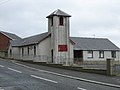
 Crumlin Presbyterian Church - geograph.org.uk - 67958.jpg 480 × 640; 78 KB
-
 Derryvolgie Parish Church - geograph.org.uk - 69653.jpg 640 × 480; 90 KB
-
 Dundrod Presbyterian Church - geograph.org.uk - 67980.jpg 640 × 480; 107 KB
-
 Dunluce Castle, near Portrush - geograph.org.uk - 69617.jpg 640 × 480; 86 KB
-

-
 First Lisburn Presbyterian Church - geograph.org.uk - 64600.jpg 640 × 480; 122 KB
-
 Lisburn Fire Station - geograph.org.uk - 69656.jpg 640 × 480; 81 KB
-
 Lisburn Reformed Presbyterian Church - geograph.org.uk - 69672.jpg 640 × 480; 71 KB
-
 Lisnagarvey radio transmitter mast - geograph.org.uk - 70063.jpg 480 × 640; 43 KB
-
 Maghaberry Elim Penticostal Church - geograph.org.uk - 62389.jpg 640 × 479; 93 KB
-
 Maghaberry Village - geograph.org.uk - 62390.jpg 640 × 479; 138 KB
-
 Murlough 3 (505952262).jpg 800 × 537; 92 KB
-
 Portbraddan from White Park Bay - geograph.org.uk - 69623.jpg 640 × 480; 90 KB
-
 Portrush across Mill Strand - geograph.org.uk - 69608.jpg 640 × 480; 100 KB
-
 Road Sign - geograph.org.uk - 67968.jpg 640 × 480; 71 KB
-
 Sainsbury's at Sprucefield Park - geograph.org.uk - 70064.jpg 640 × 480; 74 KB
-
 St John the Baptist, Upper Falls - geograph.org.uk - 67140.jpg 640 × 480; 94 KB
-
 St John's Crumlin - geograph.org.uk - 67945.jpg 640 × 480; 113 KB
-
 St Matthew's Broomhedge - geograph.org.uk - 70085.jpg 480 × 640; 141 KB
-
 The Island Civic Centre - geograph.org.uk - 64602.jpg 640 × 480; 97 KB
-
 The Point, Lisburn - geograph.org.uk - 61429.jpg 640 × 480; 87 KB
-
 View from the Bla' Hole - geograph.org.uk - 312600.jpg 640 × 426; 121 KB
-
 Whitehead from the Bla' Hole - geograph.org.uk - 312251.jpg 640 × 426; 132 KB
-
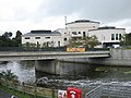
 Whitehead Station - geograph.org.uk - 312231.jpg 640 × 426; 141 KB
-
 Whitehead Station - geograph.org.uk - 312233.jpg 640 × 426; 145 KB


_-_geograph.org.uk_-_62388.jpg)


_Presbyterian_Church_-_geograph.org.uk_-_67942.jpg)


.jpg)


