Category:Oberon Council
Jump to navigation
Jump to search
Deutsch: Oberon ist ein lokales Verwaltungsgebiet (LGA) im australischen Bundesstaat New South Wales. Das Gebiet ist 3.627 km² groß und hat etwa 5.050 Einwohner. (→Oberon Council)
English: Oberon Shire is a local government area in the Central West region of New South Wales, Australia. Oberon Shire includes Oberon, Black Springs, Shooters Hill, Edith, O'Connell and Burraga. (→Oberon Shire)
Français : Le Conseil d'Oberon est une zone d'administration locale dans l'est de la Nouvelle-Galles du Sud en Australie. (→Conseil d'Oberon)
Italiano: La Contea di Oberon è una Local Government Area che si trova nel Nuovo Galles del Sud. Essa si estende su di una superficie di 3.659 chilometri quadrati ed ha una popolazione di 5.438 abitanti. La sede del consiglio si trova a Oberon. (→Contea di Oberon)
Nederlands: Oberon Council is een Local Government Area (LGA) in de Australische deelstaat Nieuw-Zuid-Wales. Oberon Council telt 4.817 inwoners. De hoofdplaats is Oberon . (→Oberon Council)
local government area in New South Wales, Australia   | |||||
| Upload media | |||||
| Instance of | |||||
|---|---|---|---|---|---|
| Location | New South Wales, AUS | ||||
| Capital | |||||
| Population |
| ||||
| Area |
| ||||
| Elevation above sea level |
| ||||
| official website | |||||
 | |||||
Subcategories
This category has the following 9 subcategories, out of 9 total.
C
- Charlton, New South Wales (1 F)
D
- Duckmaloi (1 F)
G
- Gurnang, New South Wales (2 F)
O
- Oberon Council Offices (2 F)
P
- Paling Yards, New South Wales (11 F)
R
- Roads in Oberon Shire (empty)
W
Media in category "Oberon Council"
The following 10 files are in this category, out of 10 total.
-
 Bummaroo Ford - National Park Camping Ground - panoramio.jpg 4,272 × 2,848; 3.27 MB
-
 Jenolan Caves - panoramio.jpg 2,700 × 1,800; 1.34 MB
-
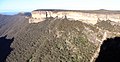
 Kanangra Walls - panoramio - Mountain Ash.jpg 3,008 × 1,895; 3.2 MB
-
 Kanangra Walls - panoramio.jpg 2,750 × 1,430; 2.36 MB
-
 Kowmung River (fire trail crossing) - panoramio.jpg 2,056 × 3,088; 4.12 MB
-
 Mayfield Gardens - panoramio (2).jpg 2,056 × 3,088; 2.21 MB
-
 Mayfield Gardens - panoramio (3).jpg 2,848 × 4,272; 5.31 MB
-
 Mayfield Gardens - panoramio.jpg 3,088 × 2,056; 2.84 MB
-
 MG 8830.tif 1,333 × 2,000; 15.32 MB
-
 Water Fall - panoramio.jpg 2,848 × 4,272; 4.97 MB


_-_panoramio.jpg)
.jpg)
.jpg)

