Category:Nyereg hill (Tihany peninsula)
Jump to navigation
Jump to search
Nyereg-hegy (223m tszf). Sajkod falu déli végétől K-re kb. 200m-re, az Apáti-hegytől DNy-ra található. Nevezetessége a Gejzírit-szikla. Lóczy-Gezr tanösvény része.
| Object location | | View all coordinates using: OpenStreetMap |
|---|
Media in category "Nyereg hill (Tihany peninsula)"
The following 7 files are in this category, out of 7 total.
-
 Kilátás a Sajkod feletti Nyereg-hegyről, balra Aszófő. Fortepan 58875.jpg 5,000 × 3,093; 5.65 MB
-
 A Bázsai-öböl a Sajkod feletti Nyereg-hegyről nézve. Fortepan 58967.jpg 6,639 × 3,824; 8.47 MB
-
 Nyereg hill. Fingerpost. - Tihany Peninsula, Hungary.JPG 1,704 × 2,272; 1,009 KB
-
 Nyereg hill. Pole. - Tihany Peninsula, Hungary.JPG 1,704 × 2,272; 948 KB
-
 Nyereg-hegyi-eresz1.jpg 492 × 662; 145 KB
-
 Signs of hiking trails on Nyerges hill. - Tihany Peninsula, Hungary.JPG 1,704 × 2,272; 970 KB
-
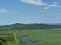 View of Külső-tó, Nyereg-hegy and Csúcs-hegy.JPG 2,560 × 1,920; 3.08 MB


