Category:Nebraska Link 80F
Jump to navigation
Jump to search
secondary state highway in Seward County, Nebraska, United States  | |||||
| Upload media | |||||
| Instance of | |||||
|---|---|---|---|---|---|
| Location | Seward County, Nebraska | ||||
| Transport network |
| ||||
| Owned by | |||||
| Maintained by | |||||
| Inception |
| ||||
| Length |
| ||||
| Terminus | |||||
| |||||
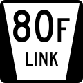
English: Media related to Nebraska Link 80F, a 5.70-mile (9.17 km) secondary state highway link near the western edge of Seward County, Nebraska, United States, that connects Interstate 80 (northwest of Beaver Crossing) with U.S. Route 34 in Tamora.
Subcategories
This category has only the following subcategory.
Media in category "Nebraska Link 80F"
This category contains only the following file.
-
 N LINK 80F.svg 600 × 600; 8 KB