Category:Morley, West Yorkshire
Jump to navigation
Jump to search
town in the City of Leeds, West Yorkshire, England, United Kingdom  | |||||
| Upload media | |||||
| Instance of | |||||
|---|---|---|---|---|---|
| Location | Leeds, West Yorkshire, Yorkshire and the Humber, England | ||||
| Different from | |||||
 | |||||
Cymraeg: Tref yn Swydd Gorllewin Efrog yw Morley. Mae gan y dref boblogaeth o 47,579.
Deutsch: Morley ist eine Stadt mit 54.051 Einwohnern (Stand: 2001) in West Yorkshire in Mittelengland und befindet sich rund 8 km südwestlich von Leeds im Leeds Metropolitan Borough. Das Metropolitan County West Yorkshire wurde 1974 gebildet, vorher war Morley Teil der Grafschaft Yorkshire. Durch Morley verläuft die Autobahn M 62 Hull-Manchester
English: Morley is a market town and civil parish within the metropolitan borough of the City of Leeds, in West Yorkshire, England. It lies approximately south-west of Leeds city centre. Together with Drighlington, Gildersome, Churwell, Tingley and East/West Ardsley, the town had a population of 47,579 in the 2001 census.
Español: Morley es una ciudad en el condado de West Yorkshire, Inglaterra, en la ciudad metropolitana de Leeds y se sitúa cinco millas de suroeste del centro de ciudad de Leeds. Con una población estimada de 47.579 que fue registrado por el censo 2001.
Nederlands: Morley is een stad (town) en civil parish in het bestuurlijke gebied City of Leeds, in het Engelse graafschap West Yorkshire. De civil parish telt
Polski: Morley – miasto w dystrykcie metropolitarnym City of Leeds, w hrabstwie West Yorkshire w Anglii.
Română: Morley este un oraş în comitatul West Yorkshire, regiunea Yorkshire and the Humber, Anglia. Oraşul se află în districtul metropolitan Leeds.
Svenska: Morley är en stad med ungefär 50 000 invånare som numera vuxit samman med Leeds, England, Storbritannien. Historiskt sett har kolbrytning och tillverkning av yllekläder varit betydande näringar.
Subcategories
This category has the following 19 subcategories, out of 19 total.
2
B
C
G
- Gildersome Tunnel (5 F)
H
M
- Morley (Top) railway station (2 F)
P
S
T
- Topcliffe Farm (4 F)
- Morley Tunnel (6 F)
V
W
Media in category "Morley, West Yorkshire"
The following 200 files are in this category, out of 1,266 total.
(previous page) (next page)-
 "Little Free Library", Scatcherd Lane - geograph.org.uk - 6367881.jpg 768 × 1,024; 276 KB
-

-
 .Morrisons car park and Nazarene church, Morley - geograph.org.uk - 6368384.jpg 1,024 × 768; 131 KB
-
 .Morrisons, Morley - fuel station and carwash - geograph.org.uk - 6368382.jpg 1,024 × 768; 130 KB
-
 .The Weaver (statue), Morley Town Hall - geograph.org.uk - 6368399.jpg 1,024 × 768; 299 KB
-
 .Windsor Court and rear of Morrisons, Morley - geograph.org.uk - 6368400.jpg 1,024 × 768; 195 KB
-
 19-21 Hey Beck Lane, West Ardsley - geograph.org.uk - 5816456.jpg 3,801 × 5,067; 4.15 MB
-
 20200720-TPE-68032-and-set.jpg 5,328 × 4,000; 7.67 MB
-
 A J Motors, Hull Street, Morley - geograph.org.uk - 6368500.jpg 1,024 × 768; 96 KB
-
 A quiet day on the M62 - geograph.org.uk - 6261788.jpg 1,024 × 768; 97 KB
-
 A643 - geograph.org.uk - 4624441.jpg 640 × 426; 54 KB
-

-

-
 Addictive Ink - Fountain Street - geograph.org.uk - 1772612.jpg 480 × 640; 80 KB
-
 Airedale Terrace - Gillroyd Parade - geograph.org.uk - 2700232.jpg 640 × 480; 72 KB
-
 Albert Road - Wide Lane - geograph.org.uk - 2852661.jpg 640 × 480; 84 KB
-
 Albert Road, Morley near Leeds - geograph.org.uk - 2356817.jpg 1,024 × 768; 235 KB
-
 Albion Street - Corporation Street - geograph.org.uk - 2699499.jpg 640 × 480; 62 KB
-
 Albion Street, Morley - geograph.org.uk - 5076064.jpg 1,024 × 682; 192 KB
-
 Alden Avenue - Hawley Way - geograph.org.uk - 2699596.jpg 640 × 492; 43 KB
-

-
 Alden Close - Alden Avenue - geograph.org.uk - 2900917.jpg 640 × 480; 83 KB
-
 Alexandra Mill, Baker Street, Morley - geograph.org.uk - 6368276.jpg 1,024 × 768; 176 KB
-
 Allotments - Marshall Street - geograph.org.uk - 2700274.jpg 640 × 480; 81 KB
-
 Allotments - off Bridge Street - geograph.org.uk - 2879956.jpg 640 × 480; 83 KB
-
 America Moor Lane - Britannia Road - geograph.org.uk - 2881256.jpg 640 × 480; 59 KB
-

-
 Appleby Way - off Ackroyd Street - geograph.org.uk - 2631505.jpg 640 × 480; 62 KB
-
 Arcadia Amusements - Albion Street - geograph.org.uk - 1771058.jpg 640 × 520; 82 KB
-
 Archbold and Iveco, Albert Road, Morley - geograph.org.uk - 1903310.jpg 1,954 × 1,290; 559 KB
-
 Archbold Carshop - Church Street - geograph.org.uk - 1780351.jpg 640 × 480; 62 KB
-
 Arkwright Walk - Hargreaves Close - geograph.org.uk - 2532562.jpg 640 × 480; 66 KB
-

-

-

-
 ASDA offices, Britannia Road, Morley - geograph.org.uk - 6367374.jpg 1,024 × 768; 156 KB
-
 ASDA supermarket, Britannia Road, Morley - geograph.org.uk - 6367375.jpg 1,024 × 768; 110 KB
-
 Ashfield Avenue - Pawson Street - geograph.org.uk - 2711584.jpg 640 × 480; 82 KB
-
 Ashfield Road - Pawson Street - geograph.org.uk - 2711574.jpg 640 × 480; 58 KB
-

-
 Aspen Court - Tingley Crescent - geograph.org.uk - 2891868.jpg 640 × 480; 60 KB
-
 Asquith Close - Asquith Drive - geograph.org.uk - 2532355.jpg 640 × 480; 61 KB
-
 Asquith Drive - Nepshaw Lane - geograph.org.uk - 2532352.jpg 640 × 480; 43 KB
-
 ATS Euromaster, Chartists Way, Morley - geograph.org.uk - 6368289.jpg 1,024 × 768; 121 KB
-
 ATS Morley - geograph.org.uk - 1121109.jpg 640 × 480; 59 KB
-
 AutoTech, Wide Lane, Morley - geograph.org.uk - 6368446.jpg 1,024 × 768; 133 KB
-
 B6123, Timothy Lane, Batley - geograph.org.uk - 6033959.jpg 1,600 × 1,064; 618 KB
-
 Baghill Green - Baghill Road - geograph.org.uk - 3065401.jpg 640 × 480; 62 KB
-

-
 Baghill Road looking north - geograph.org.uk - 2120593.jpg 800 × 600; 197 KB
-
 Baker Crescent - Baker Street - geograph.org.uk - 2699563.jpg 640 × 480; 67 KB
-
 Baker Road - Baker Street - geograph.org.uk - 2699562.jpg 640 × 480; 61 KB
-
 Baker Road - Watson Street - geograph.org.uk - 2699554.jpg 640 × 480; 52 KB
-

-
 Balfour Beatty, Howley Park Close, Morley - geograph.org.uk - 6367376.jpg 1,024 × 768; 190 KB
-
 Balti Cottage - Station Road - geograph.org.uk - 1780342.jpg 640 × 586; 100 KB
-
 Bandstand - Dartmouth Park - geograph.org.uk - 2711692.jpg 640 × 480; 98 KB
-
 Bantam Close - Wide Lane - geograph.org.uk - 2852649.jpg 640 × 480; 51 KB
-

-
 Bantam Grove Lane, Morley - geograph.org.uk - 1893611.jpg 2,000 × 1,464; 626 KB
-
 Barley Field below Scolecroft Farm - geograph.org.uk - 2467202.jpg 640 × 427; 126 KB
-

-
 Beacon Avenue - Glen Road - geograph.org.uk - 2700148.jpg 640 × 480; 69 KB
-
 Beacon Grove - Glen Road - geograph.org.uk - 2700153.jpg 640 × 491; 65 KB
-
 Beacon Works, Tingley - geograph.org.uk - 6381336.jpg 2,000 × 1,066; 678 KB
-
 Beckside View - Millbeck Approach - geograph.org.uk - 2853862.jpg 640 × 480; 77 KB
-
 Bedale - Hesketh Lane - geograph.org.uk - 3065449.jpg 640 × 480; 54 KB
-
 Beech Grove - Oak Road - geograph.org.uk - 2711666.jpg 640 × 480; 63 KB
-
 Beryl Burton Garden - geograph.org.uk - 409047.jpg 640 × 480; 128 KB
-
 Beryl Burton Gardens, Morley - geograph.org.uk - 6369069.jpg 1,024 × 768; 274 KB
-
 Beryl Burton Mural. - geograph.org.uk - 409051.jpg 640 × 480; 87 KB
-
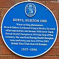 Beryl Burton OBE.jpg 2,267 × 2,269; 1.94 MB
-

-
 Birk Lane - Bruntcliffe Lane - geograph.org.uk - 2711410.jpg 480 × 640; 55 KB
-

-
 Blocked footpath off the A62, Leeds - geograph.org.uk - 6180439.jpg 2,000 × 1,500; 897 KB
-
 Blue and white sanitary bin.jpg 2,268 × 4,032; 1.62 MB
-
 Bluebells in Birkby Brow Wood - geograph.org.uk - 3967533.jpg 1,600 × 1,064; 776 KB
-
 Bluebells in Birkby Brow Wood - geograph.org.uk - 3967536.jpg 1,600 × 1,064; 883 KB
-
 Bottom of Dartmouth Avenue, Morley - geograph.org.uk - 6367342.jpg 1,024 × 768; 151 KB
-
 Bradstock Gardens - Rooms Lane - geograph.org.uk - 2630416.jpg 640 × 480; 78 KB
-
 Brambling Mews - Magpie Lane - geograph.org.uk - 2854108.jpg 640 × 480; 61 KB
-
 Bramleigh Drive - Rooms Lane - geograph.org.uk - 2630376.jpg 640 × 480; 66 KB
-
 Bramleigh Grove - Rooms Lane - geograph.org.uk - 2630381.jpg 640 × 480; 67 KB
-
 Brick outbuilding, Corporation Street, Morley - geograph.org.uk - 6368361.jpg 1,024 × 768; 164 KB
-
 Brick shed, Golf Lane, Morley - geograph.org.uk - 2141914.jpg 2,000 × 1,500; 864 KB
-
 Brickworks and flooded quarry at Howley Park - geograph.org.uk - 3349421.jpg 2,048 × 1,536; 627 KB
-
 Bridge Court - Bridge Street - geograph.org.uk - 2879940.jpg 640 × 480; 55 KB
-
 Bridge over the M62, Morley - geograph.org.uk - 2142089.jpg 2,000 × 1,478; 632 KB
-
 Briggs Buildings - Melbourne Street - geograph.org.uk - 2700257.jpg 640 × 480; 60 KB
-
 Bright Street - Queen's Promenade - geograph.org.uk - 2699483.jpg 640 × 480; 59 KB
-
 Bright Street, Morley - geograph.org.uk - 2025699.jpg 800 × 600; 246 KB
-
 Bright Street, Morley - geograph.org.uk - 2487393.jpg 1,496 × 1,122; 472 KB
-
 Brighton Avenue - off Bright Street - geograph.org.uk - 2533323.jpg 640 × 477; 43 KB
-
 Britannia Road, Morley - geograph.org.uk - 5127220.jpg 1,024 × 682; 231 KB
-
 Britannia stone quarry. - geograph.org.uk - 112650.jpg 640 × 480; 133 KB
-
 Broad Oaks - geograph.org.uk - 4206144.jpg 640 × 430; 57 KB
-
 Bruntcliffe Academy - geograph.org.uk - 6367868.jpg 1,024 × 768; 97 KB
-
 Bruntcliffe Academy - rugby pitch - geograph.org.uk - 6367867.jpg 1,024 × 768; 121 KB
-

-
 Bruntcliffe Avenue, Morley - geograph.org.uk - 2134963.jpg 2,000 × 1,495; 774 KB
-

-
 Bruntcliffe Crossroads, Morley - geograph.org.uk - 99840.jpg 640 × 480; 80 KB
-

-
 Bruntcliffe School - geograph.org.uk - 3350973.jpg 2,048 × 1,536; 729 KB
-
 Bruntcliffe Way - Bruntcliffe Avenue - geograph.org.uk - 2533315.jpg 640 × 480; 60 KB
-
 Bruntcliffe Way - Bruntcliffe Lane - geograph.org.uk - 2711421.jpg 640 × 480; 76 KB
-
 Bruntcliffe Working Men's Club - geograph.org.uk - 1197993.jpg 640 × 505; 44 KB
-
 Building behind the Powaglide works - geograph.org.uk - 6368272.jpg 1,024 × 768; 196 KB
-
 Bulls Head, Woodkirk - geograph.org.uk - 2164490.jpg 640 × 480; 65 KB
-
 Bungalows on Newlands Drive, Morley - geograph.org.uk - 3306796.jpg 1,024 × 614; 104 KB
-
 Bus Stop, Victoria Road - geograph.org.uk - 5062822.jpg 1,024 × 682; 203 KB
-
 Buses on Wellington Street, Morley - geograph.org.uk - 3725864.jpg 1,024 × 768; 182 KB
-
 Cafe, Bruntcliffe Avenue, Morley - geograph.org.uk - 2542844.jpg 640 × 480; 78 KB
-
 Cambridge Close - Albert Road - geograph.org.uk - 2631501.jpg 640 × 480; 49 KB
-
 Capitol Boulevard - Tingley Common - geograph.org.uk - 2892822.jpg 640 × 480; 72 KB
-
 Car park, White Rose Shopping Centre - geograph.org.uk - 2686321.jpg 1,024 × 768; 164 KB
-
 Car Showroom by the M62 - geograph.org.uk - 3536408.jpg 4,307 × 2,220; 1.87 MB
-
 Car Wash Centre - Bruntcliffe Road - geograph.org.uk - 668903.jpg 640 × 425; 32 KB
-
 Cardigan Avenue - Dartmouth Avenue - geograph.org.uk - 2881248.jpg 640 × 480; 56 KB
-
 Carriers Arms - Glen Road - geograph.org.uk - 2699716.jpg 640 × 480; 119 KB
-
 Chalner Avenue - Hawley Way - geograph.org.uk - 2900928.jpg 640 × 480; 70 KB
-
 Chalner Close - Hawley Way - geograph.org.uk - 2900926.jpg 640 × 480; 68 KB
-
 Chartists Court - Great Northern Street - geograph.org.uk - 1494311.jpg 640 × 480; 222 KB
-
 Chase Avenue - geograph.org.uk - 3732406.jpg 640 × 480; 59 KB
-
 Chase Avenue - The Gallops - geograph.org.uk - 2880177.jpg 640 × 480; 75 KB
-

-
 Chestnut Gardens - Rooms Lane - geograph.org.uk - 2630422.jpg 640 × 480; 76 KB
-

-
 Church Lane, Baghill Road - geograph.org.uk - 2120551.jpg 800 × 600; 230 KB
-
 Church Lane, Morley - geograph.org.uk - 2120485.jpg 800 × 600; 303 KB
-

-
 Church of Woodkirk St Mary - geograph.org.uk - 6261754.jpg 1,024 × 768; 343 KB
-
 Churwell Primary School - geograph.org.uk - 2487379.jpg 1,496 × 1,122; 598 KB
-
 Churwell railway viaduct - geograph.org.uk - 2135308.jpg 2,000 × 1,500; 805 KB
-
 Churwell, Granny Avenue - geograph.org.uk - 1822838.jpg 3,552 × 2,368; 2.15 MB
-
 Churwell,Granny Avenue - geograph.org.uk - 1822846.jpg 3,552 × 2,368; 2.02 MB
-
 City Mills, South Parade, Morley - geograph.org.uk - 6368497.jpg 1,024 × 768; 143 KB
-

-
 Clark Spring Rise - Westwood Side - geograph.org.uk - 2683386.jpg 640 × 480; 57 KB
-

-
 Cliffe Park Way - Bruntcliffe Road - geograph.org.uk - 2711432.jpg 640 × 480; 59 KB
-

-

-
-
 Cobden Mews - Cobden Street - geograph.org.uk - 2631511.jpg 640 × 480; 52 KB
-
 Cobden Street - Bright Street - geograph.org.uk - 2631510.jpg 640 × 480; 65 KB
-
 Commercial Street car park and bus stop, Morley - geograph.org.uk - 6368414.jpg 1,024 × 768; 137 KB
-
 Commercial Street Mill, Morley - geograph.org.uk - 6368426.jpg 1,024 × 768; 140 KB
-
 Commercial Street, Morley - geograph.org.uk - 6368416.jpg 1,024 × 768; 182 KB
-
 Converted chapel, Morley - geograph.org.uk - 6367381.jpg 1,024 × 768; 172 KB
-
 Converted Mill - Baker Street - geograph.org.uk - 2699568.jpg 640 × 480; 63 KB
-
 Converted mill, South Queen Street, Morley - geograph.org.uk - 6367315.jpg 1,024 × 768; 172 KB
-
 Corporation Street, Morley - geograph.org.uk - 2025693.jpg 800 × 600; 287 KB
-
 Coteroyd Avenue - off Elland Road - geograph.org.uk - 2683530.jpg 640 × 496; 74 KB
-
 Coteroyd Drive - Coteroyd Avenue - geograph.org.uk - 2683526.jpg 640 × 480; 94 KB
-
 Cottingley - geograph.org.uk - 4624431.jpg 640 × 426; 55 KB
-
 Covered Reservoir - Bruntcliffe Road - geograph.org.uk - 2711571.jpg 640 × 410; 55 KB
-
 Crank Mill ,Station Rd.,Morley - geograph.org.uk - 332844.jpg 640 × 480; 117 KB
-
 Cremation area in Woodkirk churchyard - geograph.org.uk - 6261749.jpg 1,024 × 768; 272 KB
-
 Crispin Orthotics, Victoria Road - geograph.org.uk - 5062827.jpg 1,024 × 682; 180 KB
-

-
 Croft House Rise - Croft House Way - geograph.org.uk - 2630497.jpg 640 × 480; 43 KB
-
 Croft House Road - Croft House Way - geograph.org.uk - 2630488.jpg 640 × 480; 48 KB
-

-
 Croft House Walk - Croft House Way - geograph.org.uk - 2631446.jpg 640 × 480; 55 KB
-
 Croft House Way - Croft House Rd - geograph.org.uk - 2630490.jpg 640 × 480; 54 KB
-

-

-
 Crompton Drive - Hargreaves Close - geograph.org.uk - 2532554.jpg 640 × 472; 46 KB
-
 Crompton Drive - Springfield Road - geograph.org.uk - 2532548.jpg 640 × 480; 67 KB
-
 Curlew Rise - Peacock Green - geograph.org.uk - 2853872.jpg 640 × 480; 76 KB
-
 Cycleway off Topcliffe Lane, Morley - geograph.org.uk - 1893632.jpg 2,000 × 1,500; 792 KB
-
 Cyclist on Dewsbury Road - geograph.org.uk - 6261784.jpg 1,024 × 768; 111 KB
-
 Daffil Avenue - Crossland Road - geograph.org.uk - 2683502.jpg 640 × 480; 66 KB
-
 Daffil Grange Mews - Westwood Side - geograph.org.uk - 2683482.jpg 640 × 480; 64 KB
-
 Daffil Grange Way - Westwood Side - geograph.org.uk - 2683416.jpg 640 × 480; 72 KB
-

-

-
 Daffil Road, Churwell - geograph.org.uk - 2120455.jpg 800 × 600; 174 KB
-

-
 Danger Blasting, on the Leeds Country Way - geograph.org.uk - 3306381.jpg 1,024 × 768; 166 KB
-
 Danger^ Stay away from Howley Park quarry - geograph.org.uk - 3306423.jpg 1,024 × 768; 145 KB
-
 Dartmouth Avenue - High Street - geograph.org.uk - 2699605.jpg 640 × 474; 63 KB
-

-

-
 Dartmouth Mews - Oak Road - geograph.org.uk - 2711669.jpg 640 × 480; 55 KB
-

-
 Dartmouth Park, Morley - lodge - geograph.org.uk - 6367870.jpg 1,024 × 768; 213 KB
-
 Dartmouth Park, Morley, Leeds, Yorkshire. - geograph.org.uk - 27129.jpg 640 × 480; 124 KB
-
 Dartmouth Park. Morley - Animals memorial (1) - geograph.org.uk - 6367853.jpg 1,024 × 768; 297 KB
-
 Dartmouth Park. Morley - Animals memorial (2) - geograph.org.uk - 6367855.jpg 768 × 1,024; 270 KB
-
 Dartmouth Park. Morley - Animals memorial (3) - geograph.org.uk - 6367858.jpg 768 × 1,024; 276 KB
-
 Dartmouth Park. Morley - Animals memorial (4) - geograph.org.uk - 6367859.jpg 1,024 × 768; 182 KB
-
 Dartmouth Park. Morley - bandstand - geograph.org.uk - 6367860.jpg 1,024 × 768; 279 KB
-
 Dartmouth Park. Morley - basketball court - geograph.org.uk - 6367847.jpg 1,024 × 768; 215 KB
-
 Dartmouth Park. Morley - dead tree - geograph.org.uk - 6367861.jpg 1,024 × 768; 358 KB
-
 Dartmouth Park. Morley - football pitch - geograph.org.uk - 6367865.jpg 1,024 × 768; 294 KB
-
 Dartmouth Park. Morley - formal gardens - geograph.org.uk - 6367863.jpg 1,024 × 768; 234 KB
-
 Dartmouth Park. Morley - paths and trees - geograph.org.uk - 6367846.jpg 1,024 × 768; 384 KB


,_Morley_Town_Hall_-_geograph.org.uk_-_6368399.jpg)


_-_geograph.org.uk_-_6367853.jpg)
_-_geograph.org.uk_-_6367855.jpg)
_-_geograph.org.uk_-_6367858.jpg)
_-_geograph.org.uk_-_6367859.jpg)


