Category:Montgomery, Powys
Jump to navigation
Jump to search
Български: 300px|мини|Панорамен изглед от Монтгомъри
Brezhoneg: Trefaldwyn (Montgomery e saozneg) zo ur gêr istorel e Kembre, e gevred Powys, tostik d'an harzoù gant Bro-Saoz.
Cymraeg: Mae Trefaldwyn ( Saesneg:Montgomery)yn dref hanesyddol yng ngogledd-ddwyrain Powys, bron ar y ffin â Lloegr.
Deutsch: Montgomery (walisisch: Trefaldwyn) ist die frühere Hauptstadt der Grafschaft Montgomeryshire und liegt 22 Meilen südwestlich von Shrewsbury an der B 4386 unterhalb der vom englischen König Henry III. um 1223 errichteten Burg, von der heute nur noch Ruinen zu finden sind.
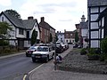
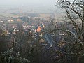
English: The historic county town of Montgomery in Mid Wales lies just three miles from the Wales-England border in the Welsh Marches. It is best known for its castle, Montgomery Castle, begun in 1223, and its parish church, begun in 1227. However its origins go back much further, as seen by the Iron age hill fort on the edge of the town. Other attractions include The Old Bell Museum, the Offa's Dyke Path, the Robber's Grave and the town wall, as well as several impressive buildings.
Français : Montgomery (en gallois : Trefaldwyn, ce qui signifie « la ville de Baudouin ») est la ville principale du comté gallois de Powys. Elle se situe au centre de la principauté, à seulement 5 km de la frontière avec l'Angleterre. Elle est connue pour son imposant château, le château de Montgomery, et son église paroissiale. Elle doit son nom à la famille de Montgommery, d'origine normande, qui vinrent durant la conquête normande de l'Angleterre (1066-1071). Roger II de Montgommery († 1093), l'un des plus puissants barons anglo-normands, fut comte de Shrewsbury et contrôla la région galloise autour de Montgommery.
county town of Montgomeryshire, now in Powys, Wales, UK  | |||||
| Upload media | |||||
| Instance of | |||||
|---|---|---|---|---|---|
| Location | Montgomery, Powys, Wales | ||||
| official website | |||||
 | |||||
Subcategories
This category has the following 13 subcategories, out of 13 total.
B
- Broad Street, Montgomery, Powys (23 F)
- Bunners, Montgomery (6 F)
C
D
- Dragon Hotel (8 F)
F
- Ffridd Faldwyn (12 F)
H
- Hendomen (4 F)
L
M
- Montgomery railway station (2 F)
- Montgomery Town Hall, Powys (19 F)
- Montgomery War Memorial (14 F)
S
T
- The Old Bell Museum (5 F)
Media in category "Montgomery, Powys"
The following 200 files are in this category, out of 552 total.
(previous page) (next page)-
 "The Old Stores" Montgomery - geograph.org.uk - 3615683.jpg 1,024 × 724; 193 KB
-

-
 A house, Montgomery NLW3361576.jpg 599 × 460; 46 KB
-
 A south view of Montgomery NLW3362300.jpg 562 × 427; 46 KB
-
 A south view of Montogmery NLW3362299.jpg 568 × 429; 40 KB
-
 A tight squeeze in Montgomery - geograph.org.uk - 2453786.jpg 640 × 480; 69 KB
-
 Anything but 90 - geograph.org.uk - 4712203.jpg 684 × 1,024; 300 KB
-
 Approach to Montgomery - geograph.org.uk - 1934762.jpg 640 × 480; 78 KB
-

-
 Approaching junction near Fairfield - geograph.org.uk - 3804915.jpg 640 × 477; 62 KB
-
 Approaching the Border - geograph.org.uk - 2605381.jpg 640 × 480; 95 KB
-
 Arthur Street, Montgomery (geograph 4323667).jpg 800 × 601; 112 KB
-
 Arthur Street, Montgomery - geograph.org.uk - 4712211.jpg 1,024 × 684; 360 KB
-
 Arthur Street, Montgomery - geograph.org.uk - 5535073.jpg 6,000 × 4,000; 7.44 MB
-
 At the Montgomeryshire War Memorial - geograph.org.uk - 4231508.jpg 640 × 360; 38 KB
-

-
 Autumn sunshine near Montgomery - geograph.org.uk - 4231510.jpg 640 × 360; 33 KB
-
 B4385 approaching Cockshutt - geograph.org.uk - 2867969.jpg 640 × 455; 70 KB
-
 B4385 approaching Cockshutt - geograph.org.uk - 3598910.jpg 640 × 492; 61 KB
-
 B4385 approaching Montgomery - geograph.org.uk - 3805013.jpg 640 × 469; 65 KB
-
 B4385 at crossroads near Hendomen - geograph.org.uk - 3808452.jpg 640 × 498; 65 KB
-
 B4385 at Offa - geograph.org.uk - 2867974.jpg 640 × 505; 77 KB
-
 B4385 east of Hendomen crossroads - geograph.org.uk - 3808454.jpg 640 × 366; 42 KB
-
 B4385 near Llwynobin - geograph.org.uk - 3805012.jpg 640 × 501; 105 KB
-
 B4385 north passed Llwynobin - geograph.org.uk - 2867984.jpg 640 × 487; 89 KB
-
 B4385 passing through woodland - geograph.org.uk - 5913914.jpg 5,184 × 3,888; 6.23 MB
-
 B4386 - geograph.org.uk - 4628965.jpg 640 × 426; 44 KB
-
 B4386 approaching Montgomery - geograph.org.uk - 3804888.jpg 640 × 485; 53 KB
-
 B4386 approaching Montgomery - geograph.org.uk - 5913888.jpg 1,080 × 810; 158 KB
-
 B4388 just north of Stalloe - geograph.org.uk - 2867998.jpg 640 × 456; 67 KB
-
 B4388 north from Montgomery - geograph.org.uk - 2867993.jpg 640 × 429; 67 KB
-
 Back on a footpath - geograph.org.uk - 1115983.jpg 640 × 480; 98 KB
-
 Barn extensions, Rhydwhyman - geograph.org.uk - 4441944.jpg 640 × 426; 52 KB
-
 Beech on Town Hill - geograph.org.uk - 1116516.jpg 480 × 640; 109 KB
-
 Bend near Weston Madoc - geograph.org.uk - 3804921.jpg 640 × 496; 65 KB
-

-
 Black and white cottages in Montgomery - geograph.org.uk - 5913882.jpg 1,080 × 810; 230 KB
-
 Brick facades, stone side walls, Princes Street, Montgomery - geograph.org.uk - 4500194.jpg 1,600 × 1,195; 1.28 MB
-
 Bridge support at Montgomery Castle - geograph.org.uk - 3617669.jpg 1,600 × 1,137; 283 KB
-
 Broad Street (Montgomery) - geograph.org.uk - 6343589.jpg 3,648 × 2,736; 3.99 MB
-
 Broad Street, Montgomery - geograph.org.uk - 5958147.jpg 1,024 × 684; 232 KB
-
 Bunner Ironmongers - geograph.org.uk - 4702675.jpg 534 × 800; 102 KB
-
 Bunner Ironmongers - geograph.org.uk - 4702681.jpg 1,024 × 684; 275 KB
-

-

-
 Burdett Row (Montgomery) - geograph.org.uk - 6221241.jpg 3,648 × 2,056; 3.3 MB
-
 Caerrhyd - geograph.org.uk - 4628970.jpg 640 × 426; 37 KB
-
 Car Park by Montgomery Recreation Ground - geograph.org.uk - 6221215.jpg 3,648 × 2,056; 3.31 MB
-
 The old Montgomery County Gaol - geograph.org.uk - 1101708.jpg 640 × 480; 97 KB
-
 Cat walking on a lane at Montgomery - geograph.org.uk - 6343592.jpg 3,648 × 2,736; 4.75 MB
-

-
 Ceiling inside St. Nicholas Church (Nave ^ Montgomery) - geograph.org.uk - 6339123.jpg 3,648 × 2,056; 1.39 MB
-
 Cherry Orchard Bungalow from B4385 - geograph.org.uk - 3597084.jpg 640 × 480; 66 KB
-
 Children collecting firewood at Montgomery (16935657981).jpg 640 × 404; 89 KB
-
 Chirbury Road, Montgomery - geograph.org.uk - 1121085.jpg 640 × 480; 97 KB
-
 Church Bank, Montgomery - geograph.org.uk - 2363126.jpg 640 × 486; 85 KB
-
 Churchyard of St Nicholas', Montgomery - geograph.org.uk - 5535123.jpg 6,000 × 4,000; 4.31 MB
-
 Colomendy, Montgomery.jpg 1,535 × 1,274; 242 KB
-
 Corndon Hill (Viewed from Montgomery) - geograph.org.uk - 6221169.jpg 3,648 × 2,056; 2.59 MB
-
 Corndon Hill (Viewed from Montgomery) - geograph.org.uk - 6343632.jpg 3,648 × 2,056; 3.13 MB
-
 Cottage beside the lane - geograph.org.uk - 4372281.jpg 640 × 360; 68 KB
-

-
 County Jail - geograph.org.uk - 541020.jpg 640 × 480; 131 KB
-
 Court Calmore - geograph.org.uk - 4628960.jpg 640 × 367; 43 KB
-
 Court Cottage - geograph.org.uk - 4441955.jpg 640 × 426; 35 KB
-
 Court Cottage from the railway - geograph.org.uk - 4553474.jpg 1,600 × 887; 243 KB
-
 Court Cottage from the railway - geograph.org.uk - 5025525.jpg 1,600 × 1,008; 120 KB
-
 Cows at Lower Gwarthlow - geograph.org.uk - 5913926.jpg 5,184 × 3,888; 3.97 MB
-
 Crossroads at the top of Pool Road, Montgomery - geograph.org.uk - 4499010.jpg 1,600 × 1,199; 1.22 MB
-

-
 Detail of Richard Herbert Memorial (Montgomery) - geograph.org.uk - 6339153.jpg 3,648 × 2,056; 3.51 MB
-
 Disco Ball inside St. Nicholas Church (Porch ^ Montgomery) - geograph.org.uk - 6222657.jpg 3,648 × 2,056; 2.04 MB
-
 Double bends below Town Hill - geograph.org.uk - 3804899.jpg 640 × 412; 48 KB
-
 Down the hill to Pullpidwr - geograph.org.uk - 3804904.jpg 640 × 480; 74 KB
-
 Dragon Hotel Montgomery - geograph.org.uk - 5123876.jpg 3,172 × 2,379; 1.35 MB
-
 Dutch barn at Pant-y-maen - geograph.org.uk - 1975074.jpg 3,008 × 2,000; 1.6 MB
-
 Edward Davies (Iolo Trefaldwyn, 1819-87) NLW3364186.jpg 343 × 554; 18 KB
-
 Edward Davies (Iolo Trefaldwyn, 1819-87) NLW3364541.jpg 345 × 550; 18 KB
-

-
 Entering Montgomery from Chirbury - geograph.org.uk - 1368650.jpg 640 × 426; 75 KB
-

-
 Entering Powys on B4385 - geograph.org.uk - 3598914.jpg 640 × 390; 51 KB
-
 Entrance to Planfa from Kerry Road - geograph.org.uk - 3804916.jpg 640 × 445; 98 KB
-
 Farm buildings at Cockshutt - geograph.org.uk - 4500216.jpg 1,600 × 1,198; 1.1 MB
-
 Farmland at Hendomen - geograph.org.uk - 3843843.jpg 1,280 × 851; 376 KB
-
 Farmland by the B4385 - geograph.org.uk - 4441949.jpg 640 × 426; 36 KB
-
 Farmland north of Montgomery - geograph.org.uk - 1974117.jpg 2,000 × 3,008; 1.47 MB
-
 Farmland north-west of Montgomery - geograph.org.uk - 1974098.jpg 426 × 640; 107 KB
-
 Farmland, Court Calmore - geograph.org.uk - 4441952.jpg 640 × 426; 32 KB
-
 Farmland, Hendomen - geograph.org.uk - 4441940.jpg 640 × 426; 40 KB
-
 Farmland, Rhydwhyman - geograph.org.uk - 4441946.jpg 640 × 426; 46 KB
-
 Field adjacent to B4385 - geograph.org.uk - 5913909.jpg 5,184 × 3,888; 3.82 MB
-
 Field near Lower Gwarthlow - geograph.org.uk - 824918.jpg 640 × 480; 67 KB
-
 Field of young barley - geograph.org.uk - 835430.jpg 640 × 480; 77 KB
-
 Field with feeders near Montgomery - geograph.org.uk - 1934745.jpg 640 × 480; 75 KB
-
 Fields of silage bales - geograph.org.uk - 1975088.jpg 3,008 × 2,000; 1.45 MB
-
 Flooding at Rhydwhyman - geograph.org.uk - 3843965.jpg 1,280 × 851; 446 KB
-
 Footpath to Ffridd Faldwyn - geograph.org.uk - 540875.jpg 640 × 480; 144 KB
-
 Foundations by Montgomery Castle (Gatehouse) - geograph.org.uk - 5874291.jpg 1,920 × 1,080; 1.06 MB
-
 Fridd Faldwyn Hillfort, Montgomery.JPG 618 × 630; 144 KB
-
 Frost and Fire - geograph.org.uk - 1063027.jpg 640 × 457; 108 KB
-
 Frost on fence, Castell-y-Gwynt - geograph.org.uk - 1116017.jpg 480 × 640; 131 KB
-
 Frost on gorse - geograph.org.uk - 1115229.jpg 640 × 442; 133 KB
-
 Frost on rose bush - geograph.org.uk - 1116109.jpg 532 × 640; 146 KB
-
 Frost on umbellifer (2) - geograph.org.uk - 1116007.jpg 640 × 480; 81 KB
-
 Frost on umbellifer - geograph.org.uk - 1115897.jpg 480 × 640; 46 KB
-
 Frost pretending to be snow - geograph.org.uk - 1116135.jpg 640 × 480; 125 KB
-

-

-
 Gate and trees below Hill Top Farm - geograph.org.uk - 1115183.jpg 640 × 480; 105 KB
-
 Gazebo at Montgomery Castle - geograph.org.uk - 5871511.jpg 4,096 × 2,304; 4.07 MB
-
 Gazebo at Montgomery Castle - geograph.org.uk - 5873776.jpg 4,096 × 2,304; 3.31 MB
-
 Gazebo at Montgomery Castle - geograph.org.uk - 5875825.jpg 1,920 × 1,080; 1.03 MB
-
 Gazebo at Montgomery Castle - geograph.org.uk - 5875829.jpg 4,096 × 2,730; 5.2 MB
-
 Gazebo at Montgomery Castle - geograph.org.uk - 6343629.jpg 3,648 × 2,056; 3.43 MB
-
 Gazebo at Montgomery Castle - geograph.org.uk - 6343637.jpg 3,648 × 2,056; 2.99 MB
-
 Gazebo at Montgomery Castle - geograph.org.uk - 6343771.jpg 3,648 × 2,056; 3.56 MB
-
 Gazebo at Montgomery Castle - geograph.org.uk - 6343828.jpg 3,648 × 2,056; 3.5 MB
-

-
 Gorse in bloom on Town Hill - geograph.org.uk - 1324719.jpg 640 × 480; 38 KB
-

-
 Grassy Path beside Montgomery Castle - geograph.org.uk - 6343845.jpg 3,648 × 2,056; 3.53 MB
-
 Hen Domen castle mound - geograph.org.uk - 1088002.jpg 640 × 480; 79 KB
-
 Herbert hatchment - geograph.org.uk - 2851051.jpg 640 × 577; 70 KB
-
 Hillside at Ffridd Faldwyn - geograph.org.uk - 540878.jpg 640 × 480; 150 KB
-
 Horses grazing at Rhydwhyman - geograph.org.uk - 4553355.jpg 1,600 × 663; 168 KB
-
 Horses grazing at Rhydwhyman - geograph.org.uk - 5025528.jpg 1,600 × 850; 109 KB
-
 Horses grazing near Rhydwhyman - geograph.org.uk - 4553495.jpg 1,600 × 728; 204 KB
-
 Houses on Princes Street (Montgomery) - geograph.org.uk - 6343619.jpg 3,648 × 2,056; 2.95 MB
-
 Houses on the B4385 Road (Montgomery) - geograph.org.uk - 6221253.jpg 3,648 × 2,056; 2.81 MB
-
 Indoor market, Montgomery - geograph.org.uk - 1314188.jpg 640 × 484; 136 KB
-

-

-
 Inside Montgomery Castle (Gatehouse) - geograph.org.uk - 5874960.jpg 1,920 × 1,080; 1.01 MB
-
 Inside the church in Montgomery - geograph.org.uk - 4231534.jpg 640 × 360; 56 KB
-
 It's Down Hill Again - geograph.org.uk - 807572.jpg 480 × 640; 68 KB
-
 Ivy House Cafe - geograph.org.uk - 4702692.jpg 1,024 × 684; 278 KB
-
 Ivy House Cafe, Montgomery - geograph.org.uk - 1934752.jpg 640 × 480; 69 KB
-
 Lane by the B4385 Road (Montgomery) - geograph.org.uk - 6221249.jpg 3,648 × 2,056; 3.47 MB
-
 Lane to Hendomen - geograph.org.uk - 3843324.jpg 1,280 × 851; 477 KB
-
 Lane to the castle - geograph.org.uk - 530065.jpg 640 × 480; 147 KB
-
 Leaving Montgomery on Kerry Road - geograph.org.uk - 3804897.jpg 640 × 423; 88 KB
-
 Leaving Town Hill - geograph.org.uk - 1116414.jpg 640 × 480; 84 KB
-
 Line of trees on Town Hill - geograph.org.uk - 1116446.jpg 640 × 480; 120 KB
-
 Lions Bank, Montgomery - geograph.org.uk - 2363136.jpg 480 × 640; 61 KB
-
 Long Mynd (Viewed from Montgomery Castle) - geograph.org.uk - 5875833.jpg 1,920 × 1,080; 1.02 MB
-

-

-
 Looking down Town Hill - geograph.org.uk - 1116522.jpg 640 × 441; 108 KB
-
 Lower Pool, Lymore Park - geograph.org.uk - 2601937.jpg 640 × 480; 102 KB
-
 Market stall, Montgomery - geograph.org.uk - 3909001.jpg 1,600 × 1,114; 573 KB
-
 Memorial of Richard Herbert (Montgomery) - geograph.org.uk - 6339133.jpg 3,648 × 2,736; 2.75 MB
-
 Memorial of Richard Herbert (Montgomery) - geograph.org.uk - 6339158.jpg 3,648 × 2,736; 2.4 MB
-

-
 Memorials inside St. Nicholas Church (Nave ^ Montgomery) - geograph.org.uk - 6339119.jpg 3,648 × 2,736; 3.12 MB
-
 Methodist school, Montgomery, Powys.jpg 1,920 × 1,080; 691 KB
-
 Minor road connecting B4385 with A490 - geograph.org.uk - 5915165.jpg 5,184 × 3,888; 5.61 MB
-
 Misericord inside St. Nicholas Church (Chancel ^ Montgomery) - geograph.org.uk - 6339224.jpg 3,648 × 2,736; 4.47 MB
-
 Misty Confusion - geograph.org.uk - 1099470.jpg 640 × 457; 24 KB
-
 Mitchell's Ford (Viewed from Montgomery) - geograph.org.uk - 6343620.jpg 3,648 × 2,056; 3.04 MB
-
 Montgomery (39691874944).jpg 4,435 × 3,079; 3.38 MB
-
 Montgomery - Broad St ^ view to Town Hall - geograph.org.uk - 6013929.jpg 5,184 × 2,920; 5.35 MB
-
 Montgomery - geograph.org.uk - 4712204.jpg 1,024 × 684; 376 KB
-
 Montgomery - St Nicholas Church - geograph.org.uk - 6013931.jpg 5,184 × 2,920; 6.37 MB
-
 Montgomery Bowling Club - geograph.org.uk - 5535116.jpg 6,000 × 4,000; 5.56 MB
-
 Montgomery Castle (Footbridge ^1) - geograph.org.uk - 5875806.jpg 1,920 × 1,080; 1.09 MB
-
 Montgomery Castle (Footbridge ^1) - geograph.org.uk - 5875810.jpg 1,920 × 1,080; 1.02 MB
-
 Montgomery Castle (Footbridge ^1) - geograph.org.uk - 5875827.jpg 1,920 × 1,080; 1.04 MB
-
 Montgomery Castle (Footbridge ^2) - geograph.org.uk - 5875781.jpg 1,920 × 1,080; 1.02 MB
-
 Montgomery Castle (Footbridge ^2) - geograph.org.uk - 6343840.jpg 3,648 × 2,056; 3.54 MB
-
 Montgomery Castle (Footbridge ^2) - geograph.org.uk - 6344004.jpg 3,648 × 2,736; 4.52 MB
-
 Montgomery Castle (Gatehouse) - geograph.org.uk - 5871705.jpg 2,048 × 2,730; 2.11 MB
-
 Montgomery Castle (Gatehouse) - geograph.org.uk - 5873612.jpg 1,920 × 1,080; 1.05 MB
-
 Montgomery Castle (Gatehouse) - geograph.org.uk - 5873675.jpg 1,920 × 1,080; 1.01 MB
-
 Montgomery Castle (Gatehouse) - geograph.org.uk - 5875288.jpg 1,920 × 1,080; 996 KB
-
 Montgomery Castle (Gatehouse) - geograph.org.uk - 6343680.jpg 3,648 × 2,056; 3.28 MB
-
 Montgomery Castle (Gatehouse) - geograph.org.uk - 6343867.jpg 2,056 × 3,648; 3.17 MB
-
 Montgomery Castle (Moat) - geograph.org.uk - 5875807.jpg 1,920 × 1,080; 1,021 KB
-
 Montgomery Castle (North-West Tower) - geograph.org.uk - 5873722.jpg 1,920 × 1,080; 1.02 MB
-
 Montgomery Castle (North-West Tower) - geograph.org.uk - 5874269.jpg 1,920 × 1,080; 1.01 MB
-
 Montgomery Castle (Wall ^1) - geograph.org.uk - 5871681.jpg 1,920 × 1,080; 1,021 KB
-
 Montgomery Castle (Wall ^2) - geograph.org.uk - 5875128.jpg 1,920 × 1,080; 1.06 MB
-
 Montgomery Castle (Wall ^2) - geograph.org.uk - 5875298.jpg 1,920 × 1,080; 1.01 MB
-
 Montgomery Castle (Wall ^3) - geograph.org.uk - 5875799.jpg 1,920 × 1,080; 1,019 KB
-
 Montgomery Castle (Wall ^4) - geograph.org.uk - 5875802.jpg 1,920 × 1,080; 1.04 MB
-
 Montgomery Castle (Wall ^4) - geograph.org.uk - 6343661.jpg 3,648 × 2,056; 3.18 MB
-
 Montgomery Castle (Well) - geograph.org.uk - 5875830.jpg 1,920 × 1,080; 1.02 MB
-
 Montgomery Castle (Well) - geograph.org.uk - 6343824.jpg 3,648 × 2,056; 3.64 MB
-
 Montgomery Castle - geograph.org.uk - 5855248.jpg 960 × 720; 297 KB
-
 Montgomery Castle - geograph.org.uk - 5855258.jpg 1,920 × 1,080; 1,015 KB
-
 Montgomery Castle - geograph.org.uk - 5871500.jpg 4,096 × 2,304; 3.35 MB
-
 Montgomery Castle - geograph.org.uk - 5871531.jpg 4,096 × 2,304; 3.73 MB
-
 Montgomery Castle - geograph.org.uk - 5871547.jpg 4,096 × 2,304; 3.51 MB
-
 Montgomery Castle - geograph.org.uk - 5873697.jpg 4,096 × 2,304; 2.84 MB
-
 Montgomery Castle - geograph.org.uk - 5873717.jpg 4,096 × 2,304; 3.75 MB
-
 Montgomery Castle - geograph.org.uk - 5875500.jpg 1,920 × 1,080; 998 KB
-
 Montgomery Castle - geograph.org.uk - 5875776.jpg 1,920 × 1,080; 1.05 MB
-
 Montgomery Castle - geograph.org.uk - 5875796.jpg 1,920 × 1,080; 1.03 MB
-
 Montgomery Castle - geograph.org.uk - 5875803.jpg 1,920 × 1,080; 1.06 MB
-
 Montgomery Castle - geograph.org.uk - 5875805.jpg 4,096 × 2,730; 4.15 MB


.jpg)


_-_geograph.org.uk_-_6343589.jpg)


_-_geograph.org.uk_-_6221241.jpg)


_-_geograph.org.uk_-_6339160.jpg)
_-_geograph.org.uk_-_6339123.jpg)

.jpg)


_-_geograph.org.uk_-_6221169.jpg)
_-_geograph.org.uk_-_6343632.jpg)


_-_geograph.org.uk_-_6339153.jpg)
_-_geograph.org.uk_-_6222657.jpg)


_NLW3364186.jpg)
_NLW3364541.jpg)
_-_geograph.org.uk_-_6339149.jpg)


_-_geograph.org.uk_-_5874291.jpg)


_-_geograph.org.uk_-_1116007.jpg)


_-_geograph.org.uk_-_6343619.jpg)
_-_geograph.org.uk_-_6221253.jpg)

_-_geograph.org.uk_-_6339117.jpg)

_-_geograph.org.uk_-_5874960.jpg)


_-_geograph.org.uk_-_6221249.jpg)


_-_geograph.org.uk_-_5875833.jpg)
_-_geograph.org.uk_-_5875903.jpg)


_-_geograph.org.uk_-_6339133.jpg)
_-_geograph.org.uk_-_6339158.jpg)

_-_geograph.org.uk_-_6339119.jpg)


_-_geograph.org.uk_-_6339224.jpg)

_-_geograph.org.uk_-_6343620.jpg)
.jpg)


_-_geograph.org.uk_-_5875806.jpg)
_-_geograph.org.uk_-_5875810.jpg)
_-_geograph.org.uk_-_5875827.jpg)
_-_geograph.org.uk_-_5875781.jpg)
_-_geograph.org.uk_-_6343840.jpg)
_-_geograph.org.uk_-_6344004.jpg)
_-_geograph.org.uk_-_5871705.jpg)
_-_geograph.org.uk_-_5873612.jpg)
_-_geograph.org.uk_-_5873675.jpg)
_-_geograph.org.uk_-_5875288.jpg)
_-_geograph.org.uk_-_6343680.jpg)
_-_geograph.org.uk_-_6343867.jpg)
_-_geograph.org.uk_-_5875807.jpg)
_-_geograph.org.uk_-_5873722.jpg)
_-_geograph.org.uk_-_5874269.jpg)
_-_geograph.org.uk_-_5871681.jpg)
_-_geograph.org.uk_-_5875128.jpg)
_-_geograph.org.uk_-_5875298.jpg)
_-_geograph.org.uk_-_5875799.jpg)
_-_geograph.org.uk_-_5875802.jpg)
_-_geograph.org.uk_-_6343661.jpg)
_-_geograph.org.uk_-_5875830.jpg)
_-_geograph.org.uk_-_6343824.jpg)


