Category:Maps of the power grid in Japan
Jump to navigation
Jump to search
Media in category "Maps of the power grid in Japan"
The following 14 files are in this category, out of 14 total.
-
 275-kV underground power lines in Nagoya.svg 384 × 288; 5 KB
-
 Central Japan 500-kV grid schematic.svg 900 × 428; 33 KB
-
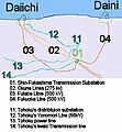 FukushimaGrid.v2.jpg 404 × 437; 41 KB
-
 Hokkaido-Honshu HVDC Link 01.svg 643 × 415; 130 KB
-
 Kii Channel HVDC Link 01.svg 600 × 400; 110 KB
-
 Power grid of Daido Denryoku in 1921.svg 750 × 600; 67 KB
-
 Power grid of Daido Denryoku in 1926.svg 2,100 × 1,500; 148 KB
-
 Power grid of Daido Denryoku in 1938 (50Hz).svg 1,900 × 1,600; 85 KB
-
 Power grid of Daido Denryoku in 1938.svg 2,200 × 2,000; 312 KB
-
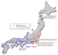 Power Grid of Japan as of 2008.png 779 × 739; 165 KB
-
 Power Grid of Japan J.PNG 780 × 740; 97 KB
-
 Power Grid of Japan.svg 2,480 × 2,600; 361 KB
-
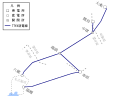
 Power grids of Yahagi Suiryoku 1.svg 1,800 × 1,800; 268 KB
-
 Power grids of Yahagi Suiryoku 2.svg 1,400 × 1,200; 146 KB


.svg)


