Category:Maps of the history of Punjab
Jump to navigation
Jump to search
Media in category "Maps of the history of Punjab"
The following 8 files are in this category, out of 8 total.
-
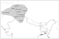 Historical geographical distribution of Sharada script.png 914 × 599; 119 KB
-
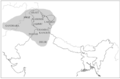 Historical geographical distribution of Sharada, borders.png 914 × 599; 121 KB
-
 Multan Old Map.jpg 960 × 548; 63 KB
-
 Punjab 1951-66.svg 1,055 × 427; 50 KB
-
 Punjab Map 1809.jpg 400 × 328; 41 KB
-
 Punjab region 1.jpg 564 × 565; 26 KB
-
 Punjab region 2.png 1,280 × 1,023; 514 KB
-
 Punjab region Map.jpg 564 × 565; 59 KB


