Category:Maps of the Carpathian Ukraine (1938-1939)
Jump to navigation
Jump to search
Maps of the Carpathian Ukraine (1938-1939), that was
an autonomous region of the second Czechoslovak Republic,
and briefly a self-proclaimed independent state, in March 1939.
(Ukrainian: Карпатська Україна, English: Carpathian Ukraine)
Media in category "Maps of the Carpathian Ukraine (1938-1939)"
The following 19 files are in this category, out of 19 total.
-
 Carpathian Ruthenia issue, 1938.svg 545 × 385; 116 KB
-
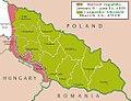
 Carpatho Ukraine March 1939.png 663 × 500; 60 KB
-
 Carpatho-Ukraine March 1939.jpg 1,011 × 773; 130 KB
-
 Druhá Československá republika 1938 podkarp. rus.png 1,660 × 942; 260 KB
-
 Europa (1939).png 1,660 × 942; 216 KB
-
 Karpatska Ukrajina 1938-39.png 275 × 173; 10 KB
-
 Léto 1938 podkarp. rus.png 1,660 × 942; 220 KB
-
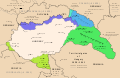
 Magyaro ÉK határváltozásai 1937-40.png 800 × 448; 116 KB
-
 Malaalenase.jpg 6,672 × 2,992; 10.77 MB
-
 Map of the Republic of Carpatho-Ukraine 1939.png 2,000 × 1,568; 108 KB
-
 Subcarpathia Carpatho-Ukraine be.svg 688 × 525; 150 KB
-
 Subcarpathia Carpatho-Ukraine german.svg 662 × 500; 365 KB
-
 Subcarpathia Carpatho-Ukraine uk.svg 664 × 501; 69 KB
-
 Subcarpathia Carpatho-Ukraine.svg 688 × 525; 105 KB
-
 Territorial gains of Hungary 1938-41 en.svg 1,443 × 941; 449 KB
-
 Territorial gains of Hungary 1938-41 es.svg 1,443 × 941; 1.08 MB
-
 Territorial gains of Hungary 1938-41 hu.svg 1,443 × 941; 494 KB
-
 Карта Карпатської України (1939).png 980 × 985; 68 KB
-
 Подкарпатская Русь (1939).svg 688 × 522; 268 KB


.png)


.png)
.svg)