Category:Maps of the Borough of Hyndburn
Jump to navigation
Jump to search
Media in category "Maps of the Borough of Hyndburn"
The following 32 files are in this category, out of 32 total.
-
 2000 Hyndburn Borough Council Election Map.png 390 × 486; 10 KB
-
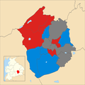
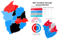 2021 Hyndburn Borough Council Election Results Map.png 3,040 × 2,043; 552 KB
-
 2022 Hyndburn Borough Council Election Results Map.png 3,040 × 2,043; 558 KB
-
 Altham UK ward locator map.svg 1,363 × 1,349; 241 KB
-
 Barnfield UK ward locator map.svg 1,363 × 1,349; 241 KB
-
 Baxenden UK ward locator map.svg 1,363 × 1,349; 241 KB
-
 Borough of Hyndburn parishes map.svg 1,319 × 1,305; 1.97 MB
-
 Central (Hyndburn ward) UK ward locator map.svg 1,363 × 1,349; 240 KB
-
 Church UK ward locator map.svg 1,363 × 1,349; 241 KB
-
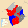 Hyndburn UK local election 2010 map.svg 512 × 507; 333 KB
-
 Hyndburn UK local election 2011 map.svg 1,319 × 1,305; 235 KB
-
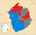
 Hyndburn UK local election 2012 map.svg 512 × 507; 335 KB
-
 Hyndburn UK local election 2014 map.svg 512 × 507; 333 KB
-
 Hyndburn UK local election 2015 map.svg 512 × 507; 304 KB
-
 Hyndburn UK local election 2016 map.svg 512 × 507; 335 KB
-
 Hyndburn UK local election 2018 map .png 960 × 952; 69 KB
-
 Hyndburn UK local election 2018 map.svg 512 × 507; 335 KB
-
 Hyndburn UK local election 2019 map.png 937 × 926; 137 KB
-
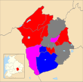
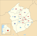
 Hyndburn UK local election 2021 Map.png 1,024 × 1,013; 142 KB
-
 Hyndburn UK local election 2022 map.png 1,451 × 1,436; 200 KB
-
 Hyndburn UK local election 2023 map.png 937 × 926; 165 KB
-
 Hyndburn UK locator map.svg 1,116 × 1,305; 1.25 MB
-
 Hyndburn UK ward map 2010 (blank).svg 1,319 × 1,305; 235 KB
-
 Hyndburn UK ward map 2019 (councillors).svg 1,363 × 1,349; 257 KB
-
 Hyndburn UK ward map 2020 (councillors).svg 1,363 × 1,349; 257 KB
-
 Hyndburn UK ward map 2021 (councillors).png 4,542 × 4,498; 789 KB
-
 Hyndburn unparished area UK locator map.svg 1,319 × 1,305; 176 KB
-
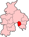 LancashireHyndburn.png 200 × 250; 19 KB
-
 Location map United Kingdom Borough of Hyndburn.svg 1,319 × 1,305; 2.86 MB
-
 Map of Lancashire Sheet 063, Ordnance Survey, 1846-1873.tiff 10,691 × 7,153; 218.79 MB
-
 Netherton UK ward locator map.svg 1,363 × 1,349; 241 KB
-
 Overton UK ward locator map.svg 1,363 × 1,349; 241 KB


_UK_ward_locator_map.svg)


.svg)
.svg)
.png)


.svg)